TopoQuest Logo
Do you find TopoQuest useful?
Help keep TopoQuest running and adding new maps/features by donating!
Bitcoin:  19c7KJd3qBynnjoSw5npx9KScwjBe4ifkT
Litecoin:  LXs6TkuXGGXo1vDsWCkWVdjQX94eUKd6ui
Home View Maps Find Maps Find Places Resources & Links


King, Wisconsin Topographic Map

USGS Map Title: King, WI
USGS Map MRC: 44089C2
DRG (GeoTIFF) Download: o44089c2.tif


Neighboring USGS Topographic Map Quads:


  Amherst, WI  
44089D3
 

  Scandinavia, WI  
44089D2
 

  Ogdensburg, WI  
44089D1
 

  Blaine, WI  
44089C3
 

  King, WI  
44089C2
 

  Waupaca, WI  
44089C1
 

  Wautoma NE, WI  
44089B3
 

  Wild Rose, WI  
44089B2
 

  Saxeville, WI  
44089B1


Map MRC Location:

N45°
W90°
N45°
W89°
H8 H7 H6 H5 H4 H3 H2 H1
G8 G7 G6 G5 G4 G3 G2 G1
F8 F7 F6 F5 F4 F3 F2 F1
E8 E7 E6 E5 E4 E3 E2 E1
D8 D7 D6 D5 D4 D3 D2 D1
C8 C7 C6 C5 C4 C3 C2 C1
B8 B7 B6 B5 B4 B3 B2 B1
A8 A7 A6 A5 A4 A3 A2 A1
N44°
W90°
N44°
W89°

King, WI USGS 1:24K Topographic Map Preview:
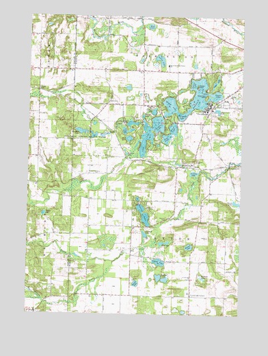
King, WI USGS Topographic Map
Click on map above to begin viewing in our Map Viewer.

This topographic map contains these locations and features:
Feature Name Type Latitude Longitude GNIS ID View Map
Allen CreekStreamN44.3261°W89.2018°1560774View Map
Badger CemeteryCemeteryN44.3447°W89.2438°1561066View Map
Badger School (historical)SchoolN44.3525°W89.2440°1851443View Map
Barton SchoolSchoolN44.3519°W89.1834°1561214View Map
Beasley LakeLakeN44.3292°W89.1818°1850407View Map
Benedict BridgeBridgeN44.3322°W89.1829°1850409View Map
Brownes PointCapeN44.3350°W89.1626°1850415View Map
Camp OnawayLocaleN44.3455°W89.1515°1850417View Map
Central Wisconsin Veterans Memorial CemeteryCemeteryN44.3335°W89.1422°1850602View Map
Chain O' LakesLakeN44.3339°W89.1690°1562931View Map
Chain O' LakesPopulated PlaceN44.3292°W89.1699°2399760View Map
Chain O' Lakes Census Designated PlaceCensusN44.3319°W89.1671°2585060View Map
Chain O' Lakes Elementary SchoolSchoolN44.3544°W89.1688°1561920View Map
Chain O' Lakes-King Census Designated Place (historical)CensusN44.3307°W89.1669°2393370View Map
Columbia LakeLakeN44.3297°W89.1744°1563280View Map
Crystal LakeLakeN44.2719°W89.1724°1563585View Map
Crystal Lake CemeteryCemeteryN44.2647°W89.1554°1850429View Map
Crystal Lake ChurchChurchN44.2647°W89.1540°1563597View Map
Crystal Lake CornersLocaleN44.2575°W89.1537°1563598View Map
Dake LakeLakeN44.3239°W89.1690°1563665View Map
Deans LakeLakeN44.2918°W89.2405°1563787View Map
Dopp School (historical)SchoolN44.2558°W89.2384°1851466View Map
Edmunds DockLocaleN44.3408°W89.1393°1850435View Map
Emmons CreekStreamN44.3228°W89.1837°1564639View Map
Emmons Creek Barrens State Natural AreaParkN44.3072°W89.2312°2061071View Map
Emmons LakeLakeN44.3173°W89.1925°1564640View Map
Emmons PeninsulaCapeN44.3214°W89.1854°1850442View Map
George LakeLakeN44.3409°W89.1444°1850460View Map
Government IslandIslandN44.3416°W89.1457°1565688View Map
Greenwood ForestWoodsN44.3369°W89.1601°1850464View Map
Hartman CreekStreamN44.3283°W89.1948°1581154View Map
Hartman Creek Number Five DamDamN44.3250°W89.2168°1792096View Map
Hartman Creek Number One DamDamN44.3250°W89.2018°1792302View Map
Hartman Creek State ParkParkN44.3233°W89.2173°1566109View Map
Hartman LakeLakeN44.3267°W89.2196°1566110View Map
Hartman Lake 2ReservoirN44.3250°W89.2168°1792097View Map
Hartman Lake 3ReservoirN44.3251°W89.2052°1792303View Map
Holman LakeLakeN44.2784°W89.1549°1566557View Map
Indian CrossingCrossingN44.3328°W89.1712°1850473View Map
Indian Crossing BridgeBridgeN44.3328°W89.1712°1850474View Map
Jenson LakeLakeN44.2970°W89.1277°1567154View Map
Junction LakeLakeN44.3093°W89.1528°1567318View Map
KingPopulated PlaceN44.3375°W89.1418°1567492View Map
King Post OfficePost OfficeN44.3374°W89.1458°2768327View Map
Knight LakeLakeN44.3302°W89.1902°1567572View Map
Lake NymphaeaLakeN44.3450°W89.1373°1850527View Map
Lake OrlandoLakeN44.3300°W89.1862°1850532View Map
Limekiln LakeLakeN44.3347°W89.1674°1850485View Map
Long CoveBayN44.3222°W89.1779°1850493View Map
Long LakeLakeN44.3226°W89.1815°1568541View Map
Loyola VillaBuildingN44.3441°W89.1465°1850494View Map
Manomin LakeLakeN44.3274°W89.1898°1850498View Map
Marl LakeLakeN44.3236°W89.1911°1569056View Map
McCrossen LakeLakeN44.3335°W89.1603°1569190View Map
Merriam PointCapeN44.3344°W89.1568°1850510View Map
Miner LakeLakeN44.3278°W89.1651°1569548View Map
Mount JoelSummitN44.3278°W89.1926°1850478View Map
Mud LakeLakeN44.2800°W89.1697°1569923View Map
Mud LakeLakeN44.3708°W89.1792°1569924View Map
Mud Lake-Radley Creek Savanna State Natural AreaParkN44.2805°W89.1696°2061759View Map
Murry CreekStreamN44.2716°W89.1993°1570053View Map
Mynyard LakeLakeN44.2834°W89.1810°1570080View Map
Nessling LakeLakeN44.3358°W89.1561°1850515View Map
Newsome LakeLakeN44.2651°W89.1466°1570262View Map
Norris PointCapeN44.3369°W89.1554°1850523View Map
Onaway IslandIslandN44.3455°W89.1512°1570820View Map
Otter CreekGutN44.3436°W89.1434°1850533View Map
Otter LakeLakeN44.3473°W89.1409°1570908View Map
Ottman LakeLakeN44.3351°W89.1766°1570923View Map
ParfreyvillePopulated PlaceN44.3128°W89.1312°1571033View Map
Pearl CreekStreamN44.2561°W89.2409°1571125View Map
Pleasant Valley CemeteryCemeteryN44.3094°W89.2084°1571646View Map
Point RichmondCapeN44.3353°W89.1571°1850543View Map
Pope LakeLakeN44.3268°W89.1937°1571766View Map
Pope Lake State Natural AreaParkN44.3283°W89.1946°2061767View Map
Radley CreekStreamN44.3086°W89.1512°1572022View Map
Rainbow LakeLakeN44.3420°W89.1499°1572038View Map
Round LakeLakeN44.2627°W89.1857°1572645View Map
Round LakeLakeN44.3384°W89.1673°1572646View Map
RuralPopulated PlaceN44.3130°W89.1532°1572728View Map
Rural CemeteryCemeteryN44.3099°W89.1582°1850548View Map
Sandbar LakesLakeN44.2655°W89.1726°1573702View Map
Sherman School (historical)SchoolN44.3739°W89.2043°1850570View Map
Shung-we CreekGutN44.3250°W89.1934°1850571View Map
Silver LakeLakeN44.3567°W89.1733°1574137View Map
Stratton LakeLakeN44.2917°W89.1818°1574973View Map
Sunset LakeLakeN44.3466°W89.1537°1575111View Map
Taylor LakeLakeN44.3420°W89.1403°1575276View Map
Tomorrow's Children SchoolSchoolN44.3507°W89.1671°2716858View Map
Town of DaytonCivilN44.2868°W89.1637°1583056View Map
Town of FarmingtonCivilN44.3744°W89.1648°1583194View Map
Waupaca Boys CampLocaleN44.2950°W89.1809°1576321View Map
White Eagle PointCapeN44.3297°W89.1648°1850600View Map
Williams IslandIslandN44.3430°W89.1490°1576766View Map
Wisconsin Veterans Home - King Fire DepartmentBuildingN44.3361°W89.1441°2697550View Map
Youngs LakeLakeN44.3331°W89.1830°1577118View Map

Note: Coordinates in the location and feature list above are referenced to NAD83 datum.


Copyright (C) 2008-2024 Ryan Niemi / Sunset Dynamics ... All Rights Reserved