TopoQuest Logo
Do you find TopoQuest useful?
Help keep TopoQuest running and adding new maps/features by donating!
Bitcoin:  19c7KJd3qBynnjoSw5npx9KScwjBe4ifkT
Litecoin:  LXs6TkuXGGXo1vDsWCkWVdjQX94eUKd6ui
Home View Maps Find Maps Find Places Resources & Links


Amherst, Wisconsin Topographic Map

USGS Map Title: Amherst, WI
USGS Map MRC: 44089D3
DRG (GeoTIFF) Download: o44089d3.tif


Neighboring USGS Topographic Map Quads:


  Polonia, WI  
44089E4
 

  New Hope, WI  
44089E3
 

  Iola, WI  
44089E2
 

  Arnott, WI  
44089D4
 

  Amherst, WI  
44089D3
 

  Scandinavia, WI  
44089D2
 

  Almond, WI  
44089C4
 

  Blaine, WI  
44089C3
 

  King, WI  
44089C2


Map MRC Location:

N45°
W90°
N45°
W89°
H8 H7 H6 H5 H4 H3 H2 H1
G8 G7 G6 G5 G4 G3 G2 G1
F8 F7 F6 F5 F4 F3 F2 F1
E8 E7 E6 E5 E4 E3 E2 E1
D8 D7 D6 D5 D4 D3 D2 D1
C8 C7 C6 C5 C4 C3 C2 C1
B8 B7 B6 B5 B4 B3 B2 B1
A8 A7 A6 A5 A4 A3 A2 A1
N44°
W90°
N44°
W89°

Amherst, WI USGS 1:24K Topographic Map Preview:
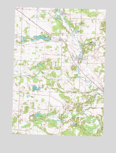
Amherst, WI USGS Topographic Map
Click on map above to begin viewing in our Map Viewer.

This topographic map contains these locations and features:
Feature Name Type Latitude Longitude GNIS ID View Map
17 ReservoirReservoirN44.3900°W89.3068°1791999View Map
AmherstPopulated PlaceN44.4508°W89.2848°1560831View Map
Amherst DamDamN44.4516°W89.2834°1792206View Map
Amherst Elementary SchoolSchoolN44.4546°W89.2853°2716240View Map
Amherst Fire District Fire and RescueBuildingN44.4470°W89.2962°2697627View Map
Amherst High SchoolSchoolN44.4555°W89.2851°2716344View Map
Amherst JunctionPopulated PlaceN44.4689°W89.3126°1560833View Map
Amherst Middle SchoolSchoolN44.4551°W89.2852°2716652View Map
Amherst Millpond 90ReservoirN44.4568°W89.2824°1792207View Map
Bear CreekStreamN44.4336°W89.2859°1561356View Map
Bickel CemeteryCemeteryN44.4541°W89.3154°1561672View Map
Camp MikquandLocaleN44.4900°W89.3176°1562638View Map
Ell LakeLakeN44.4678°W89.3615°1564534View Map
Fancher SchoolSchoolN44.4719°W89.3748°1564853View Map
Fountain Grove School (historical)SchoolN44.4322°W89.3448°1851475View Map
General Irwin School (historical)SchoolN44.3986°W89.2848°1851479View Map
Greenwood CemeteryCemeteryN44.4521°W89.2931°1560832View Map
Kimball CemeteryCemeteryN44.4169°W89.3654°1851496View Map
Lake BingoLakeN44.3862°W89.2894°1561803View Map
Lake Ell FieldAirportN44.4627°W89.3553°1581856View Map
Lake EmilyLakeN44.4703°W89.3378°1564622View Map
Lake Emily (historical)Populated PlaceN44.4778°W89.3348°1851499View Map
Lake JuliaLakeN44.4675°W89.3496°1567311View Map
Lake LimeLakeN44.4208°W89.3451°1568059View Map
Lower Amherst CemeteryCemeteryN44.4344°W89.2746°1568714View Map
Meyers LakeLakeN44.4779°W89.2904°1569395View Map
NelsonvillePopulated PlaceN44.4950°W89.3098°1570168View Map
Nelsonville DamDamN44.4941°W89.3118°1792210View Map
Nelsonville Pond (historical)ReservoirN44.4959°W89.3145°1570170View Map
Oak Grove CemeteryCemeteryN44.4536°W89.2690°1570616View Map
Polley School (historical)SchoolN44.4122°W89.3665°1851538View Map
Saint Mary of Mount Carmel CemeteryCemeteryN44.4702°W89.3748°1573260View Map
Spring CreekStreamN44.3964°W89.2759°1574616View Map
Spring Creek 3 WR 878 DamDamN44.3900°W89.3068°1791998View Map
Spring LakeLakeN44.3941°W89.3388°1574666View Map
Tomorrow RiverStreamN44.4335°W89.2860°1575504View Map
Town of AmherstCivilN44.4602°W89.2938°1582690View Map
Turtle LakeLakeN44.4666°W89.2674°1575738View Map
Valley View School (historical)SchoolN44.4036°W89.3251°1851591View Map
Village of AmherstCivilN44.4472°W89.2833°1582689View Map
Village of Amherst JunctionCivilN44.4686°W89.3170°1582691View Map
Village of NelsonvilleCivilN44.4938°W89.3091°1583791View Map

Note: Coordinates in the location and feature list above are referenced to NAD83 datum.


Copyright (C) 2008-2025 Ryan Niemi / Sunset Dynamics ... All Rights Reserved