TopoQuest Logo
Do you find TopoQuest useful?
Help keep TopoQuest running and adding new maps/features by donating!
Bitcoin:  19c7KJd3qBynnjoSw5npx9KScwjBe4ifkT
Litecoin:  LXs6TkuXGGXo1vDsWCkWVdjQX94eUKd6ui
Home View Maps Find Maps Find Places Resources & Links


Kings Beach, California Topographic Map

USGS Map Title: Kings Beach, CA
USGS Map MRC: 39120B1
DRG (GeoTIFF) Download: o39120b1.tif


Neighboring USGS Topographic Map Quads:


  Truckee, CA  
39120C2
 

  Martis Peak, CA  
39120C1
 

  Mount Rose, NV  
39119C8
 

  Tahoe City, CA  
39120B2
 

  Kings Beach, CA  
39120B1
 

  Marlette Lake, NV  
39119B8
 

  Homewood, CA  
39120A2
 

  Meeks Bay, CA  
39120A1
 

  Glenbrook, NV  
39119A8


Map MRC Location:

N40°
W121°
N40°
W120°
H8 H7 H6 H5 H4 H3 H2 H1
G8 G7 G6 G5 G4 G3 G2 G1
F8 F7 F6 F5 F4 F3 F2 F1
E8 E7 E6 E5 E4 E3 E2 E1
D8 D7 D6 D5 D4 D3 D2 D1
C8 C7 C6 C5 C4 C3 C2 C1
B8 B7 B6 B5 B4 B3 B2 B1
A8 A7 A6 A5 A4 A3 A2 A1
N39°
W121°
N39°
W120°

Kings Beach, CA USGS 1:24K Topographic Map Preview:
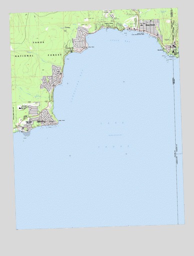
Kings Beach, CA USGS Topographic Map
Click on map above to begin viewing in our Map Viewer.

This topographic map contains these locations and features:
Feature Name Type Latitude Longitude GNIS ID View Map
Agate BayBayN39.2335°W120.0402°256134View Map
Atagam BeachBeachN39.2382°W120.0460°1723403View Map
Brockaway Post Office (historical)Post OfficeN39.2266°W120.0121°2026843View Map
BrockwayPopulated PlaceN39.2266°W120.0121°1658141View Map
Brockway Golf ClubLocaleN39.2391°W120.0335°1654183View Map
Brockway SpringSpringN39.2480°W120.0133°257472View Map
Brockway VistaPopulated PlaceN39.2380°W120.0152°1723413View Map
Brockway Winter Sports CenterLocaleN39.2455°W120.0360°1662347View Map
Burton CreekStreamN39.1813°W120.1232°257738View Map
Carnelian BayBayN39.2113°W120.0816°257984View Map
Carnelian BayPopulated PlaceN39.2269°W120.0819°257985View Map
Carnelian Bay Census Designated PlaceCensusN39.2347°W120.0766°2628716View Map
Carnelian Bay Post OfficePost OfficeN39.2269°W120.0821°2769335View Map
Carnelian Bay Post Office (historical)Post OfficeN39.2269°W120.0819°2026847View Map
Carnelian CanyonValleyN39.2269°W120.0805°257986View Map
Carnelian HeightsPopulated PlaceN39.2096°W120.1016°1723416View Map
Cedar FlatFlatN39.2152°W120.0932°1662291View Map
Coon Street Picnic AreaLocaleN39.2352°W120.0224°1723420View Map
Crystal BayPopulated PlaceN39.2260°W120.0041°859430View Map
Crystal Bay Census Designated PlaceCensusN39.2315°W120.0016°2583915View Map
Crystal Bay Post OfficePost OfficeN39.2290°W120.0033°864725View Map
Dollar CreekStreamN39.1971°W120.0949°1662294View Map
Dollar PointPopulated PlaceN39.1880°W120.0999°1723422View Map
Dollar PointCapeN39.1855°W120.0924°1662295View Map
Dollar Point Census Designated PlaceCensusN39.1905°W120.1089°2408680View Map
Dollar ReservoirReservoirN39.2012°W120.1088°1662296View Map
Flick PointCapeN39.2288°W120.0680°1662298View Map
Griff CreekStreamN39.2369°W120.0302°266778View Map
Kings BeachPopulated PlaceN39.2377°W120.0266°1662302View Map
Kings Beach Branch Auburn-Placer County LibraryBuildingN39.2382°W120.0269°1723435View Map
Kings Beach Census Designated PlaceCensusN39.2490°W120.0201°2408481View Map
Kings Beach Elementary SchoolSchoolN39.2403°W120.0280°1723348View Map
Kings Beach Post OfficePost OfficeN39.2364°W120.0210°1723436View Map
Kings Beach State Recreation AreaParkN39.2363°W120.0280°274749View Map
Lake ForestPopulated PlaceN39.1844°W120.1146°1662304View Map
Lake Forest CampgroundLocaleN39.1846°W120.1069°1662349View Map
Lake Tahoe DivisionCivilN39.1530°W120.1082°1935160View Map
Moondunes BeachBeachN39.2374°W120.0427°1723446View Map
North Lake Tahoe Fire Protection District Station 12BuildingN39.2268°W120.0043°2581295View Map
North Tahoe Fire Protection District Station 52 North TahoeBuildingN39.2385°W120.0310°2622172View Map
North Tahoe Fire Protection District Station 54 North TahoeBuildingN39.1899°W120.1050°2622163View Map
North Tahoe Fire Protection District Station 55 North TahoeBuildingN39.2273°W120.0821°2622173View Map
North Tahoe Regional ParkParkN39.2480°W120.0496°1723448View Map
North Tahoe Regional ParkParkN39.2482°W120.0530°274748View Map
Patton BeachBeachN39.2282°W120.0685°1723450View Map
Placer County Sheriff's Office Tahoe SubstationBuildingN39.1882°W120.1199°2751032View Map
RidgewoodPopulated PlaceN39.2157°W120.0924°1723455View Map
Secline BeachBeachN39.2374°W120.0321°1723461View Map
Stateline LookoutLocaleN39.2313°W120.0088°274750View Map
Stateline PointCapeN39.2221°W120.0021°861569View Map
Tahoe EstatesPopulated PlaceN39.2441°W120.0566°1723468View Map
Tahoe Marina EstatesPopulated PlaceN39.2407°W120.0619°1723469View Map
Tahoe NordicLocaleN39.2007°W120.1099°1662348View Map
Tahoe VistaPopulated PlaceN39.2399°W120.0510°1662317View Map
Tahoe Vista Census Designated PlaceCensusN39.2483°W120.0535°2410050View Map
Tahoe Vista Post OfficePost OfficeN39.2398°W120.0484°1723470View Map
Watson CreekStreamN39.2185°W120.0863°268812View Map
Wood VistaPopulated PlaceN39.2424°W120.0324°1723477View Map

Note: Coordinates in the location and feature list above are referenced to NAD83 datum.


Copyright (C) 2008-2024 Ryan Niemi / Sunset Dynamics ... All Rights Reserved