TopoQuest Logo
Do you find TopoQuest useful?
Help keep TopoQuest running and adding new maps/features by donating!
Bitcoin:  19c7KJd3qBynnjoSw5npx9KScwjBe4ifkT
Litecoin:  LXs6TkuXGGXo1vDsWCkWVdjQX94eUKd6ui
Home View Maps Find Maps Find Places Resources & Links


Martis Peak, California Topographic Map

USGS Map Title: Martis Peak, CA
USGS Map MRC: 39120C1
DRG (GeoTIFF) Download: o39120c1.tif


Neighboring USGS Topographic Map Quads:


  Hobart Mills, CA  
39120D2
 

  Boca, CA  
39120D1
 

  Mount Rose NW, NV  
39119D8
 

  Truckee, CA  
39120C2
 

  Martis Peak, CA  
39120C1
 

  Mount Rose, NV  
39119C8
 

  Tahoe City, CA  
39120B2
 

  Kings Beach, CA  
39120B1
 

  Marlette Lake, NV  
39119B8


Map MRC Location:

N40°
W121°
N40°
W120°
H8 H7 H6 H5 H4 H3 H2 H1
G8 G7 G6 G5 G4 G3 G2 G1
F8 F7 F6 F5 F4 F3 F2 F1
E8 E7 E6 E5 E4 E3 E2 E1
D8 D7 D6 D5 D4 D3 D2 D1
C8 C7 C6 C5 C4 C3 C2 C1
B8 B7 B6 B5 B4 B3 B2 B1
A8 A7 A6 A5 A4 A3 A2 A1
N39°
W121°
N39°
W120°

Martis Peak, CA USGS 1:24K Topographic Map Preview:
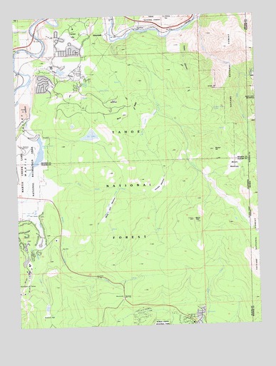
Martis Peak, CA USGS Topographic Map
Click on map above to begin viewing in our Map Viewer.

This topographic map contains these locations and features:
Feature Name Type Latitude Longitude GNIS ID View Map
Alpine Meadow CampgroundLocaleN39.3205°W120.1219°274783View Map
Brockway Guard StationLocaleN39.2696°W120.0857°1654184View Map
Brockway SummitSummitN39.2610°W120.0713°257473View Map
Buck MeadowsFlatN39.3405°W120.0738°257573View Map
Buck RidgeRidgeN39.3371°W120.0644°257586View Map
Buck SpringSpringN39.3446°W120.0816°257593View Map
Burned HillSummitN39.3205°W120.0230°257710View Map
Casey CanyonValleyN39.3674°W120.0388°258043View Map
Dry LakeLakeN39.3269°W120.0871°259575View Map
East Martis CreekStreamN39.3174°W120.1149°259766View Map
Gold Star PeakSummitN39.2564°W120.0886°2745591View Map
Gray CreekStreamN39.3728°W120.0316°260825View Map
HirschdalePopulated PlaceN39.3685°W120.0760°1658760View Map
Hirschdale PitMineN39.3681°W120.1083°2677934View Map
Juniper CreekStreamN39.3654°W120.0724°262050View Map
Juniper FlatFlatN39.3655°W120.0946°266869View Map
Juniper HillSummitN39.3455°W120.0230°262052View Map
Juniper Ridge SpringSpringN39.3370°W120.0229°262055View Map
KBCH-FM (Kings Beach)TowerN39.2619°W120.0735°1665047View Map
KHTZ-AM (Truckee)TowerN39.2880°W120.1030°1664989View Map
Kingswood EstatesPopulated PlaceN39.2552°W120.0635°1723437View Map
Klondike MeadowFlatN39.3060°W120.0507°262214View Map
Martis CreekStreamN39.3499°W120.1183°263239View Map
Martis Creek LakeReservoirN39.3202°W120.1140°1655186View Map
Martis Creek Lake DamDamN39.3291°W120.1177°1664535View Map
Martis PeakSummitN39.2916°W120.0327°263240View Map
Martis ValleyValleyN39.3466°W120.1183°263241View Map
Martis Valley PitMineN39.3386°W120.1206°2680210View Map
McKay SpringSpringN39.3477°W120.0909°263379View Map
Middle Martis CreekStreamN39.3019°W120.1210°263544View Map
Monte Carlo CreekStreamN39.3052°W120.0733°263760View Map
Monte Carlo MeadowsFlatN39.2980°W120.0771°263761View Map
Mount BaldySummitN39.2785°W120.0002°858803View Map
Murphy MeadowsFlatN39.3138°W120.0127°263978View Map
North Fork Gray CreekStreamN39.3499°W120.0033°264166View Map
North Star Ski AreaLocaleN39.2557°W120.1227°1655225View Map
Northstar-at-Tahoe Ski AreaLocaleN39.2732°W120.1024°1662426View Map
Old Joerger RanchLocaleN39.3127°W120.1149°264328View Map
Placer County Fire Department Station 31 / Northstar Fire DepartmentBuildingN39.2810°W120.1198°2621971View Map
Prosser CreekStreamN39.3705°W120.1169°1654935View Map
Reservoir A 1086 DamDamN39.2582°W120.1110°1664425View Map
Sawmill FlatFlatN39.2535°W120.1091°265868View Map
Truckee Fire Protection District Station 95 GlenshireBuildingN39.3619°W120.0989°2622170View Map
Union MillsPopulated PlaceN39.3538°W120.1071°1660080View Map
Union ValleyValleyN39.3588°W120.1116°268591View Map
West Fork Gray CreekStreamN39.3503°W120.0084°268901View Map
West Juniper CreekStreamN39.3371°W120.0513°268924View Map
West Martis CreekStreamN39.3016°W120.1219°268929View Map

Note: Coordinates in the location and feature list above are referenced to NAD83 datum.


Copyright (C) 2008-2025 Ryan Niemi / Sunset Dynamics ... All Rights Reserved