TopoQuest Logo
Do you find TopoQuest useful?
Help keep TopoQuest running and adding new maps/features by donating!
Bitcoin:  19c7KJd3qBynnjoSw5npx9KScwjBe4ifkT
Litecoin:  LXs6TkuXGGXo1vDsWCkWVdjQX94eUKd6ui
Home View Maps Find Maps Find Places Resources & Links


Kingston South, Oklahoma Topographic Map

USGS Map Title: Kingston South, OK
USGS Map MRC: 33096H6
DRG (GeoTIFF) Download: o33096h6.tif


Neighboring USGS Topographic Map Quads:


  Madill, OK  
34096A7
 

  Kingston North, OK  
34096A6
 

  Little City, OK  
34096A5
 

  Shay, OK  
33096H7
 

  Kingston South, OK  
33096H6
 

  Platter, OK  
33096H5
 

  Gordonville, TX  
33096G7
 

  Pottsboro, TX  
33096G6
 

  Denison Dam, TX  
33096G5


Map MRC Location:

N34°
W97°
N34°
W96°
H8 H7 H6 H5 H4 H3 H2 H1
G8 G7 G6 G5 G4 G3 G2 G1
F8 F7 F6 F5 F4 F3 F2 F1
E8 E7 E6 E5 E4 E3 E2 E1
D8 D7 D6 D5 D4 D3 D2 D1
C8 C7 C6 C5 C4 C3 C2 C1
B8 B7 B6 B5 B4 B3 B2 B1
A8 A7 A6 A5 A4 A3 A2 A1
N33°
W97°
N33°
W96°

Kingston South, OK USGS 1:24K Topographic Map Preview:
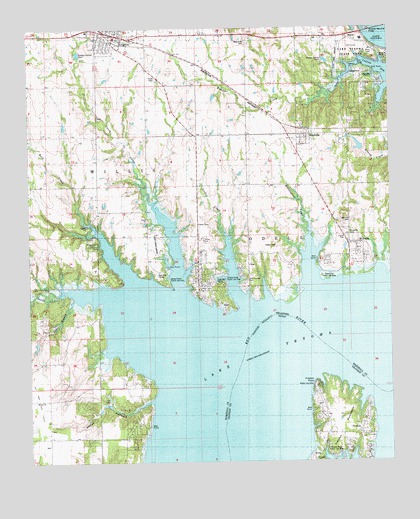
Kingston South, OK USGS Topographic Map
Click on map above to begin viewing in our Map Viewer.

This topographic map contains these locations and features:
Feature Name Type Latitude Longitude GNIS ID View Map
Bald Knob CemeteryCemeteryN33.9964°W96.6744°1089809View Map
Caney - Soldier Fire DepartmentBuildingN33.9328°W96.6887°2657176View Map
Caney CreekStreamN33.9265°W96.6981°1102953View Map
Caney Creek Airport (historical)AirportN33.9382°W96.7064°1777563View Map
Caney Creek Public Use AreaParkN33.9282°W96.7019°1777562View Map
Catfish BayBayN33.9887°W96.6278°1091039View Map
Glen Eden (historical)Populated PlaceN33.8895°W96.6417°2034683View Map
Hainline CemeteryCemeteryN33.9444°W96.6389°1093483View Map
Happy HollowValleyN33.8931°W96.7085°1093519View Map
Isom Springs CemeteryCemeteryN33.9288°W96.6736°1094138View Map
Isom Springs Oil FieldOilfieldN33.8932°W96.7222°1094139View Map
KingstonPopulated PlaceN33.9987°W96.7197°1102958View Map
Kingston Fire DepartmentBuildingN33.9988°W96.7187°2656851View Map
Kingston Police DepartmentBuildingN33.9989°W96.7193°2766640View Map
Lake SchoolSchoolN33.8754°W96.7447°1094478View Map
Lake Texoma State ParkParkN33.9923°W96.6400°1102959View Map
Lake Texoma State Park AirportAirportN33.9929°W96.6425°1102527View Map
Mayrant CemeteryCemeteryN33.8754°W96.6518°1362338View Map
McBridePopulated PlaceN33.9354°W96.6333°1095207View Map
McLaughlin CreekStreamN33.9265°W96.6517°1095265View Map
New WoodvillePopulated PlaceN33.9698°W96.6536°1100004View Map
Oil BranchStreamN33.9190°W96.7372°1096182View Map
Oknoname 095003 DamDamN33.9634°W96.6319°1751320View Map
Oknoname 095003 ReservoirReservoirN33.9634°W96.6319°1751321View Map
PrestonPopulated PlaceN33.8823°W96.6331°1380395View Map
Preston Bend Public Use AreaParkN33.8764°W96.6461°1889618View Map
Preston PointCapeN33.8976°W96.6500°1365760View Map
Roads End Public Use AreaParkN33.9287°W96.6467°1777560View Map
Rock CreekStreamN33.9284°W96.7150°1097277View Map
Rooster CreekStreamN33.9870°W96.6381°1097423View Map
Sandy CreekStreamN33.9240°W96.7400°1097807View Map
Soldier CreekStreamN33.9215°W96.6758°1098180View Map
Soldier Creek Public Use AreaParkN33.9279°W96.6761°1777561View Map
South Marshall DivisionCivilN33.9331°W96.7494°1937867View Map
Texama Fire DistrictBuildingN33.9704°W96.6398°2656896View Map
Texoma Fire District Station 3BuildingN33.9356°W96.6366°2657126View Map
Town of KingstonCivilN33.9979°W96.6952°2412835View Map
Town of New WoodvilleCivilN33.9687°W96.6549°2413047View Map
Township of OdellCivilN33.9584°W96.6586°1824714View Map
Woodville CemeteryCemeteryN33.9391°W96.6386°1100005View Map

Note: Coordinates in the location and feature list above are referenced to NAD83 datum.


Copyright (C) 2008-2025 Ryan Niemi / Sunset Dynamics ... All Rights Reserved