TopoQuest Logo
Do you find TopoQuest useful?
Help keep TopoQuest running and adding new maps/features by donating!
Bitcoin:  19c7KJd3qBynnjoSw5npx9KScwjBe4ifkT
Litecoin:  LXs6TkuXGGXo1vDsWCkWVdjQX94eUKd6ui
Home View Maps Find Maps Find Places Resources & Links


Little City, Oklahoma Topographic Map

USGS Map Title: Little City, OK
USGS Map MRC: 34096A5
DRG (GeoTIFF) Download: o34096a5.tif


Neighboring USGS Topographic Map Quads:


  Tishomingo, OK  
34096B6
 

  Milburn, OK  
34096B5
 

  Caddo NW, OK  
34096B4
 

  Kingston North, OK  
34096A6
 

  Little City, OK  
34096A5
 

  Durant North, OK  
34096A4
 

  Kingston South, OK  
33096H6
 

  Platter, OK  
33096H5
 

  Durant South, OK  
33096H4


Map MRC Location:

N35°
W97°
N35°
W96°
H8 H7 H6 H5 H4 H3 H2 H1
G8 G7 G6 G5 G4 G3 G2 G1
F8 F7 F6 F5 F4 F3 F2 F1
E8 E7 E6 E5 E4 E3 E2 E1
D8 D7 D6 D5 D4 D3 D2 D1
C8 C7 C6 C5 C4 C3 C2 C1
B8 B7 B6 B5 B4 B3 B2 B1
A8 A7 A6 A5 A4 A3 A2 A1
N34°
W97°
N34°
W96°

Little City, OK USGS 1:24K Topographic Map Preview:
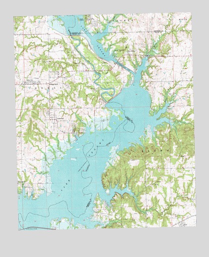
Little City, OK USGS Topographic Map
Click on map above to begin viewing in our Map Viewer.

This topographic map contains these locations and features:
Feature Name Type Latitude Longitude GNIS ID View Map
Aylesworth CemeteryCemeteryN34.0278°W96.6173°2709116View Map
BeePopulated PlaceN34.1220°W96.5722°1089957View Map
Confederate CemeteryCemeteryN34.1031°W96.5513°1091610View Map
CumberlandPopulated PlaceN34.0645°W96.5997°1091884View Map
Cumberland CemeteryCemeteryN34.0711°W96.5983°2709117View Map
Cumberland CutChannelN34.0954°W96.5503°1763691View Map
Cumberland LeveeLeveeN34.1020°W96.5686°1091886View Map
Cumberland Oil FieldOilfieldN34.0887°W96.5717°1091887View Map
Denny McCoy 1 DamDamN34.0934°W96.6136°1754240View Map
Denny McCoy 1 ReservoirReservoirN34.0934°W96.6136°1754241View Map
Fort WashitaPopulated PlaceN34.1029°W96.5464°1100425View Map
Goat IslandIslandN34.1220°W96.5800°1093219View Map
Kansas CreekStreamN34.0976°W96.5325°1094289View Map
Lakewood Volunteer Fire DepartmentBuildingN34.0392°W96.5353°2657030View Map
LinnPopulated PlaceN34.1182°W96.6250°1100585View Map
Little CityPopulated PlaceN34.0862°W96.6161°1094739View Map
Mead Post OfficePost OfficeN34.0017°W96.5097°1817843View Map
Newberry CreekStreamN34.0220°W96.5669°1095850View Map
Oknoname 013018 DamDamN34.0051°W96.5519°1756072View Map
Oknoname 013018 ReservoirReservoirN34.0051°W96.5519°1756073View Map
Oknoname 023001 DamDamN34.1134°W96.5353°1751278View Map
Oknoname 023001 ReservoirReservoirN34.1134°W96.5353°1751279View Map
Old Channel Washita RiverChannelN34.0943°W96.5706°1096233View Map
Post CemeteryCemeteryN34.1057°W96.5458°1096858View Map
Robinson CornerPopulated PlaceN34.0854°W96.6014°1100794View Map
Rock CreekStreamN34.0901°W96.5667°1097278View Map
Rock CreekStreamN34.1115°W96.5686°1097297View Map
Southeast Aylesworth Oil FieldOilfieldN34.0090°W96.5603°1098286View Map
Texoma Public Hunting AreaParkN34.0612°W96.5025°1763554View Map
Town of MeadCivilN34.0008°W96.5110°2412971View Map
Township of BrownCivilN34.0445°W96.5142°1824705View Map
Tri - City Fire DepartmentBuildingN34.0677°W96.5978°2657273View Map
Tri - City Fire Department Station 2BuildingN34.0851°W96.6197°2657293View Map
Weder Number 1 DamDamN34.0168°W96.5203°1756084View Map
Weder Number 1 ReservoirReservoirN34.0168°W96.5203°1756085View Map
West Bryan County Fire and RescueBuildingN34.0012°W96.5102°2656986View Map
West Mead Oil FieldOilfieldN34.0009°W96.5522°1099582View Map
Widow Moore CreekStreamN34.0637°W96.5278°1099753View Map

Note: Coordinates in the location and feature list above are referenced to NAD83 datum.


Copyright (C) 2008-2025 Ryan Niemi / Sunset Dynamics ... All Rights Reserved