TopoQuest Logo
Do you find TopoQuest useful?
Help keep TopoQuest running and adding new maps/features by donating!
Bitcoin:  19c7KJd3qBynnjoSw5npx9KScwjBe4ifkT
Litecoin:  LXs6TkuXGGXo1vDsWCkWVdjQX94eUKd6ui
Home View Maps Find Maps Find Places Resources & Links


Platter, Oklahoma Topographic Map

USGS Map Title: Platter, OK
USGS Map MRC: 33096H5
DRG (GeoTIFF) Download: o33096h5.tif


Neighboring USGS Topographic Map Quads:


  Kingston North, OK  
34096A6
 

  Little City, OK  
34096A5
 

  Durant North, OK  
34096A4
 

  Kingston South, OK  
33096H6
 

  Platter, OK  
33096H5
 

  Durant South, OK  
33096H4
 

  Pottsboro, TX  
33096G6
 

  Denison Dam, TX  
33096G5
 

  Achille, OK  
33096G4


Map MRC Location:

N34°
W97°
N34°
W96°
H8 H7 H6 H5 H4 H3 H2 H1
G8 G7 G6 G5 G4 G3 G2 G1
F8 F7 F6 F5 F4 F3 F2 F1
E8 E7 E6 E5 E4 E3 E2 E1
D8 D7 D6 D5 D4 D3 D2 D1
C8 C7 C6 C5 C4 C3 C2 C1
B8 B7 B6 B5 B4 B3 B2 B1
A8 A7 A6 A5 A4 A3 A2 A1
N33°
W97°
N33°
W96°

Platter, OK USGS 1:24K Topographic Map Preview:
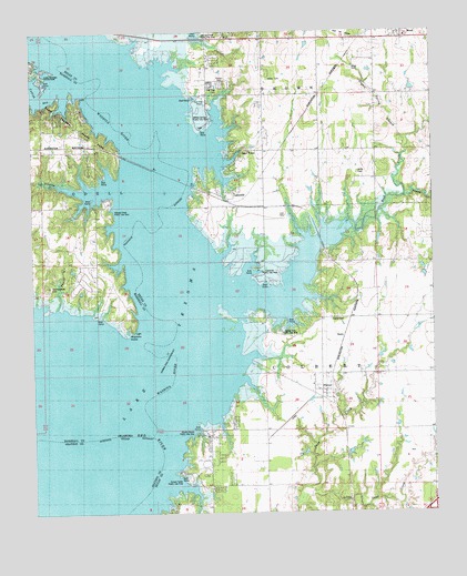
Platter, OK USGS Topographic Map
Click on map above to begin viewing in our Map Viewer.

This topographic map contains these locations and features:
Feature Name Type Latitude Longitude GNIS ID View Map
Alberta CreekStreamN33.9598°W96.5975°1089569View Map
Alberta Creek Public Use AreaParkN33.9534°W96.6003°1777920View Map
BarryLocaleN33.9209°W96.5294°1777911View Map
Double Spring BranchStreamN33.9726°W96.5075°1092151View Map
Franklin CemeteryCemeteryN33.9634°W96.5228°1093013View Map
Johnson Creek Public Use AreaParkN33.9993°W96.5697°1777916View Map
LakesidePopulated PlaceN33.9551°W96.5519°1100562View Map
Lakeside Public Use AreaParkN33.9376°W96.5508°1777914View Map
Little Sand CreekStreamN33.8784°W96.5417°1094832View Map
Love CemeteryCemeteryN33.9522°W96.5461°1095019View Map
MeadPopulated PlaceN33.9995°W96.5092°1095280View Map
Mead CemeteryCemeteryN33.9906°W96.5247°1095281View Map
Moore CreekStreamN33.9565°W96.5011°1095498View Map
Oknoname 013003 DamDamN33.9868°W96.5036°1757911View Map
Oknoname 013003 ReservoirReservoirN33.9868°W96.5036°1757912View Map
Oknoname 013012 DamDamN33.9851°W96.5153°1756060View Map
Oknoname 013012 ReservoirReservoirN33.9851°W96.5153°1756061View Map
Old Woodville CemeteryCemeteryN33.9339°W96.6194°1777919View Map
PlatterPopulated PlaceN33.9070°W96.5350°1096710View Map
Platter CemeteryCemeteryN33.9249°W96.5324°1096711View Map
Platter Census Designated PlaceCensusN33.9066°W96.5338°2629935View Map
Platter Flats Public Use AreaParkN33.9218°W96.5450°1777913View Map
Platter Post OfficePost OfficeN33.9066°W96.5357°1818289View Map
Rock CreekStreamN33.9515°W96.5197°1097293View Map
Sand PointPopulated PlaceN33.9645°W96.5625°1097780View Map
Sunset Camp Public Use AreaParkN33.8843°W96.5781°1777918View Map
Taylor CreekStreamN33.9287°W96.6158°1098768View Map
Teeter CreekStreamN33.9570°W96.5089°1098790View Map
Texoma Fire District Station 2BuildingN33.9398°W96.6080°2657127View Map
Washita PointCapeN33.9212°W96.5947°1099415View Map
Washita RiverStreamN33.9118°W96.5781°1101723View Map
West Bryan County Fire Department Station 7BuildingN33.9986°W96.5558°2657169View Map
Willafa Woods Public Use AreaParkN33.8959°W96.5733°1777917View Map
Willis CemeteryCemeteryN33.9631°W96.5230°1777912View Map
Willow Springs Public Use AreaParkN33.9779°W96.5717°1777915View Map

Note: Coordinates in the location and feature list above are referenced to NAD83 datum.


Copyright (C) 2008-2025 Ryan Niemi / Sunset Dynamics ... All Rights Reserved