TopoQuest Logo
Do you find TopoQuest useful?
Help keep TopoQuest running and adding new maps/features by donating!
Bitcoin:  19c7KJd3qBynnjoSw5npx9KScwjBe4ifkT
Litecoin:  LXs6TkuXGGXo1vDsWCkWVdjQX94eUKd6ui
Home View Maps Find Maps Find Places Resources & Links


Kinzel Springs, Tennessee Topographic Map

USGS Map Title: Kinzel Springs, TN
USGS Map MRC: 35083F7
DRG (GeoTIFF) Download: o35083f7.tif


Neighboring USGS Topographic Map Quads:


  Maryville, TN  
35083G8
 

  Wildwood, TN  
35083G7
 

  Walden Creek, TN  
35083G6
 

  Blockhouse, TN  
35083F8
 

  Kinzel Springs, TN  
35083F7
 

  Wear Cove, TN  
35083F6
 

  Calderwood, TN  
35083E8
 

  Cades Cove, TN  
35083E7
 

  Thunderhead Mountain, NC  
35083E6


Map MRC Location:

N36°
W84°
N36°
W83°
H8 H7 H6 H5 H4 H3 H2 H1
G8 G7 G6 G5 G4 G3 G2 G1
F8 F7 F6 F5 F4 F3 F2 F1
E8 E7 E6 E5 E4 E3 E2 E1
D8 D7 D6 D5 D4 D3 D2 D1
C8 C7 C6 C5 C4 C3 C2 C1
B8 B7 B6 B5 B4 B3 B2 B1
A8 A7 A6 A5 A4 A3 A2 A1
N35°
W84°
N35°
W83°

Kinzel Springs, TN USGS 1:24K Topographic Map Preview:
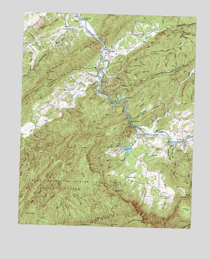
Kinzel Springs, TN USGS Topographic Map
Click on map above to begin viewing in our Map Viewer.

This topographic map contains these locations and features:
Feature Name Type Latitude Longitude GNIS ID View Map
Ace GapGapN35.6704°W83.8307°1275436View Map
Ace Gap CampsiteLocaleN35.6715°W83.8324°1652173View Map
Alie MountainSummitN35.6998°W83.7564°1275568View Map
Amerine CemeteryCemeteryN35.6815°W83.8616°1642445View Map
Amrines Forge (historical)LocaleN35.6845°W83.8624°1642588View Map
Bark Camp RunStreamN35.6459°W83.8405°1276302View Map
Beard Cane CampsiteLocaleN35.6356°W83.8724°1652175View Map
Beard Cane CreekStreamN35.6626°W83.8502°1276633View Map
Beard Cane GapGapN35.6315°W83.8693°1276634View Map
Beard Cane MountainRidgeN35.6382°W83.8628°1276635View Map
Bearpen RidgeRidgeN35.6267°W83.8385°1276657View Map
Big SinkBasinN35.6476°W83.7593°1277385View Map
Black Mash HollowValleyN35.6741°W83.7609°1277583View Map
Blair BranchStreamN35.6940°W83.8427°1277635View Map
Blount County Fire Protection District Station 5BuildingN35.7310°W83.8161°2654780View Map
Briar BranchStreamN35.6890°W83.7968°1278307View Map
Briar BranchStreamN35.6948°W83.7988°1278308View Map
Cagle HollowValleyN35.7324°W83.7618°1279288View Map
Campground ChurchChurchN35.6740°W83.7660°1305650View Map
Campground HollowValleyN35.6744°W83.7649°1305652View Map
Cane CreekStreamN35.6709°W83.8730°1279515View Map
Cane RidgeRidgeN35.6588°W83.8733°1279540View Map
Capshaw BranchStreamN35.6995°W83.8010°1279641View Map
Carr CreekStreamN35.6834°W83.7905°1305697View Map
Caylor ChapelChurchN35.6890°W83.7588°1305750View Map
Caylor School (historical)SchoolN35.6901°W83.7580°1308122View Map
Caylors Chapel CemeteryCemeteryN35.6896°W83.7593°1642541View Map
Cerulean KnobSummitN35.6287°W83.7852°1652471View Map
Chestnut CoveValleyN35.7135°W83.8079°1280375View Map
Chestnut RidgeRidgeN35.7453°W83.8504°1280408View Map
Chilhowee GapGapN35.7334°W83.8171°1642590View Map
City of TownsendCivilN35.6758°W83.7525°2405597View Map
Cold Spring GapGapN35.6251°W83.8255°1280899View Map
College Hill School (historical)SchoolN35.6715°W83.7782°1642600View Map
Commissioner District 8CivilN35.6478°W83.8157°2464659View Map
Cooper HollowValleyN35.6694°W83.7963°1281210View Map
Coughron School (historical)SchoolN35.7051°W83.8393°1308138View Map
Cowan SpringsSpringN35.7498°W83.8093°1642589View Map
Crooked RidgeRidgeN35.6362°W83.8243°1281680View Map
Dan BranchStreamN35.6698°W83.8721°1282002View Map
Davis BranchStreamN35.6973°W83.8077°1282120View Map
Double BranchStreamN35.7434°W83.7663°1282683View Map
Double MountainSummitN35.6283°W83.7909°1282694View Map
Double Mountain CampsiteLocaleN35.6348°W83.7918°1652177View Map
Dry ValleyValleyN35.6642°W83.7859°1283021View Map
Dunn HollowValleyN35.7406°W83.7590°1283209View Map
Dunn SpringSpringN35.6673°W83.7796°1283213View Map
East Mountain View ChurchChurchN35.7379°W83.7916°1283387View Map
Emert BluffCliffN35.6840°W83.7957°1642596View Map
Flat CreekStreamN35.6773°W83.8735°1284380View Map
Fowler HollowValleyN35.7176°W83.8027°1284749View Map
Fry FieldsFlatN35.6551°W83.8110°1284997View Map
Garland HollowValleyN35.7355°W83.7880°1285166View Map
Green HollowValleyN35.7286°W83.7649°1286104View Map
Grindstone RidgeRidgeN35.7129°W83.8653°1286318View Map
Hatcher CreekStreamN35.7065°W83.8274°1287106View Map
Hatcher MountainRidgeN35.6453°W83.8688°1269629View Map
Henrys Fort (historical)LocaleN35.7362°W83.8213°1646818View Map
Hesse CreekStreamN35.7126°W83.8191°1287513View Map
Hesse Creek CampsiteLocaleN35.6612°W83.8491°1652180View Map
Hodge BranchStreamN35.7418°W83.7830°1269646View Map
Hogan HollowValleyN35.6539°W83.8454°1287989View Map
Hurricane BranchStreamN35.6793°W83.8668°1288782View Map
Hurricane MountainSummitN35.6721°W83.8412°1288834View Map
Huskey BranchStreamN35.7418°W83.7830°1269669View Map
Johns BranchStreamN35.6656°W83.8641°1289509View Map
Kelly Gap CampsiteLocaleN35.6548°W83.8191°1652181View Map
Kelly RidgeRidgeN35.6549°W83.8151°1290042View Map
Kinzel BranchStreamN35.6859°W83.7974°1290277View Map
Kinzel SpringsPopulated PlaceN35.6870°W83.7963°1290278View Map
Lane GapGapN35.7101°W83.8571°1290608View Map
Laurel LakeReservoirN35.6707°W83.7957°1290756View Map
Laurel Lake DamDamN35.6712°W83.7941°1307141View Map
Laurel Valley Golf CourseLocaleN35.6687°W83.8088°1308121View Map
Laws SchoolSchoolN35.7304°W83.8691°1290798View Map
Lawson CrossroadPopulated PlaceN35.6543°W83.7974°1290812View Map
Lick BranchStreamN35.6709°W83.8002°1291174View Map
Little MountainSummitN35.6553°W83.7629°1291576View Map
Luke MountainSummitN35.6910°W83.7820°1642592View Map
Mark MountainSummitN35.6911°W83.7863°1292689View Map
Martins Mill (historical)LocaleN35.7093°W83.8235°1642593View Map
Matthew MountainSummitN35.7070°W83.7722°1292952View Map
Meadow BranchStreamN35.7262°W83.7705°1293485View Map
MelrosePopulated PlaceN35.7459°W83.8352°1293556View Map
Middleset HollowValleyN35.7388°W83.7593°1293712View Map
Mill Dam RidgeRidgeN35.6711°W83.8161°1293859View Map
Miller CoveValleyN35.7270°W83.8138°1293943View Map
Miller CovePopulated PlaceN35.7098°W83.8174°1315513View Map
Miller Cove MountainSummitN35.7308°W83.7833°1293945View Map
Millers Cove Baptist ChurchChurchN35.7131°W83.8246°1293944View Map
Millers Cove CemeteryCemeteryN35.7140°W83.8235°1642498View Map
Millers Cove ChurchChurchN35.7040°W83.8391°1293973View Map
Mount NeboSummitN35.7290°W83.8262°1294684View Map
Mount Nebo (historical)Populated PlaceN35.7259°W83.8399°1308117View Map
Pinestand KnobSummitN35.7270°W83.7791°1297597View Map
Powell RidgeRidgeN35.6597°W83.8155°1298424View Map
Raven Cliff RidgeRidgeN35.7106°W83.7934°1298966View Map
Red BankPopulated PlaceN35.6434°W83.7682°1315788View Map
Red Bank School (historical)SchoolN35.6434°W83.7680°1308130View Map
Reed CreekStreamN35.7429°W83.7727°1299139View Map
Rich MountainSummitN35.6287°W83.7852°1652488View Map
Rich Mountain GapGapN35.6456°W83.8052°1299322View Map
Ridge GapGapN35.7290°W83.7824°1299390View Map
Rigsby BranchStreamN35.7306°W83.7660°1299443View Map
Roaring BranchStreamN35.7451°W83.7635°1299561View Map
Rocky BranchPopulated PlaceN35.7409°W83.8410°1299845View Map
Rocky Branch ChurchChurchN35.7326°W83.8518°1299877View Map
Rocky Branch SchoolSchoolN35.7426°W83.8357°1299878View Map
Rocky KnobSummitN35.6692°W83.7598°1299908View Map
Scott GapGapN35.6395°W83.7593°1642657View Map
SeatonPopulated PlaceN35.7320°W83.8707°1308115View Map
Shell BranchStreamN35.6584°W83.8438°1269995View Map
Short CreekStreamN35.6834°W83.7913°1303605View Map
Short MountainSummitN35.6434°W83.8473°1270208View Map
Slate Quarry HollowValleyN35.6720°W83.8013°1270476View Map
Smith BranchStreamN35.7401°W83.7588°1270561View Map
Smith KnobSummitN35.7195°W83.7914°1270698View Map
Spicewood BranchStreamN35.7401°W83.8721°1270997View Map
Springhouse HollowValleyN35.7167°W83.7536°1271147View Map
Stillhouse BranchStreamN35.7418°W83.7632°1271397View Map
Stony RidgeRidgeN35.6256°W83.8447°1271527View Map
SunshinePopulated PlaceN35.6834°W83.7935°1642597View Map
Tennessee Department of Agriculture Division of Forestry BlountBuildingN35.7410°W83.7755°2654794View Map
Tipton BranchStreamN35.6759°W83.7910°1272679View Map
TownsendPopulated PlaceN35.6754°W83.7557°1272813View Map
Townsend Area Volunteer Fire Department Station 1BuildingN35.6746°W83.7551°2654330View Map
Townsend Area Volunteer Fire Department Station 2BuildingN35.6546°W83.7739°2654933View Map
Townsend Division (historical)CensusN35.6862°W83.8391°1648611View Map
Townsend High SchoolSchoolN35.6734°W83.7552°1642599View Map
Townsend Police DepartmentBuildingN35.6746°W83.7552°2765711View Map
Townsend SchoolSchoolN35.6745°W83.7552°1642598View Map
Trunk BranchStreamN35.6854°W83.8580°1272922View Map
TuckaleecheePopulated PlaceN35.6734°W83.7749°1649494View Map
Tuckaleechee Campground CemeteryCemeteryN35.6745°W83.7665°1642518View Map
Tuckaleechee ChapelChurchN35.6715°W83.7766°1304180View Map
Tuckaleechee Chapel CemeteryCemeteryN35.6724°W83.7774°1642519View Map
Tuckaleechee CoveValleyN35.6787°W83.7926°1314097View Map
Turkey Pen Ridge CampsiteLocaleN35.6256°W83.7641°1652184View Map
Walker CemeteryCemeteryN35.7467°W83.8313°1304333View Map
Walker Chapel (historical)ChurchN35.7465°W83.8302°1308116View Map
WallandPopulated PlaceN35.7281°W83.8132°1273687View Map
Walland Census Designated PlaceCensusN35.7320°W83.8068°2586084View Map
Walland Elementary SchoolSchoolN35.7312°W83.8107°1308119View Map
Walland High School (historical)SchoolN35.7298°W83.8105°1642591View Map
Walland Middle SchoolSchoolN35.7306°W83.8107°1308118View Map
Walland Post OfficePost OfficeN35.7293°W83.8167°1649490View Map
Water HollowValleyN35.6432°W83.7663°1273881View Map
WatertownPopulated PlaceN35.7381°W83.7880°1304410View Map
Webb CoveValleyN35.7242°W83.7905°1274026View Map
Webb KnobSummitN35.7159°W83.7854°1274035View Map
West Millers CovePopulated PlaceN35.7104°W83.8291°1308120View Map
Wilburn BranchStreamN35.7034°W83.8202°1274518View Map
Wolf CreekStreamN35.6929°W83.8457°1274942View Map
Zack RidgeRidgeN35.6609°W83.7637°1275349View Map

Note: Coordinates in the location and feature list above are referenced to NAD83 datum.


Copyright (C) 2008-2024 Ryan Niemi / Sunset Dynamics ... All Rights Reserved