TopoQuest Logo
Do you find TopoQuest useful?
Help keep TopoQuest running and adding new maps/features by donating!
Bitcoin:  19c7KJd3qBynnjoSw5npx9KScwjBe4ifkT
Litecoin:  LXs6TkuXGGXo1vDsWCkWVdjQX94eUKd6ui
Home View Maps Find Maps Find Places Resources & Links


Walden Creek, Tennessee Topographic Map

USGS Map Title: Walden Creek, TN
USGS Map MRC: 35083G6
DRG (GeoTIFF) Download: o35083g6.tif


Neighboring USGS Topographic Map Quads:


  Shooks Gap, TN  
35083H7
 

  Boyds Creek, TN  
35083H6
 

  Douglas Dam, TN  
35083H5
 

  Wildwood, TN  
35083G7
 

  Walden Creek, TN  
35083G6
 

  Pigeon Forge, TN  
35083G5
 

  Kinzel Springs, TN  
35083F7
 

  Wear Cove, TN  
35083F6
 

  Gatlinburg, TN  
35083F5


Map MRC Location:

N36°
W84°
N36°
W83°
H8 H7 H6 H5 H4 H3 H2 H1
G8 G7 G6 G5 G4 G3 G2 G1
F8 F7 F6 F5 F4 F3 F2 F1
E8 E7 E6 E5 E4 E3 E2 E1
D8 D7 D6 D5 D4 D3 D2 D1
C8 C7 C6 C5 C4 C3 C2 C1
B8 B7 B6 B5 B4 B3 B2 B1
A8 A7 A6 A5 A4 A3 A2 A1
N35°
W84°
N35°
W83°

Walden Creek, TN USGS 1:24K Topographic Map Preview:
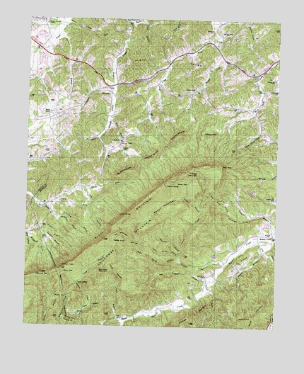
Walden Creek, TN USGS Topographic Map
Click on map above to begin viewing in our Map Viewer.

This topographic map contains these locations and features:
Feature Name Type Latitude Longitude GNIS ID View Map
Antioch Baptist ChurchChurchN35.8468°W83.6288°1304853View Map
Bearwallow MountainSummitN35.7698°W83.7324°1276672View Map
Bench MountainSummitN35.7962°W83.6835°1276996View Map
Benson SchoolSchoolN35.7887°W83.6299°1277024View Map
Berry GapGapN35.7723°W83.7304°1277056View Map
Big Bridge BranchStreamN35.7951°W83.6382°1277264View Map
Big Pine MountainSummitN35.8137°W83.6988°1277354View Map
Blue Rock MountainSummitN35.7726°W83.7129°1277773View Map
Bluff MountainSummitN35.8043°W83.6835°1277829View Map
Bogle Spring BranchStreamN35.7773°W83.6729°1305335View Map
Boone BranchStreamN35.8740°W83.7299°1277978View Map
Bridge CreekStreamN35.8656°W83.6568°1278343View Map
Butt BranchStreamN35.8334°W83.7091°1279194View Map
Camelick BranchStreamN35.7890°W83.7430°1279361View Map
Canelick branchStreamN35.7890°W83.7432°1312979View Map
Carter BranchStreamN35.7990°W83.7399°1279777View Map
Chinquapin CemeteryCemeteryN35.7537°W83.7016°1645393View Map
Chinquapin ChurchChurchN35.7537°W83.7013°1280486View Map
Chinquapin School (historical)SchoolN35.7537°W83.7010°1323352View Map
Claiborne Baker CemeteryCemeteryN35.8681°W83.6371°1645394View Map
Clear ForkStreamN35.7681°W83.6591°1305958View Map
Coldspring BranchStreamN35.7948°W83.7349°1306027View Map
Commissioner District 10CivilN35.8610°W83.6825°2464324View Map
Commissioner District 2CivilN35.7576°W83.6374°2463971View Map
Commissioner District 9CivilN35.8692°W83.7249°2464744View Map
Compton BranchStreamN35.7976°W83.6621°1281050View Map
Cove CreekStreamN35.7856°W83.6285°1281405View Map
CusickPopulated PlaceN35.8479°W83.7093°1314924View Map
Doyle SpringsPopulated PlaceN35.7676°W83.7235°1314974View Map
Dripping Springs Baptist ChurchChurchN35.8065°W83.7207°1645402View Map
Dripping Springs SchoolSchoolN35.8043°W83.7288°1282805View Map
Dry BranchStreamN35.8062°W83.7207°1282847View Map
DupontPopulated PlaceN35.8262°W83.7021°1306400View Map
Dupont Baptist ChurchChurchN35.8259°W83.7035°1645403View Map
Dupont CemeteryCemeteryN35.8223°W83.7018°1283036View Map
Dupont School (historical)SchoolN35.8245°W83.7038°1323358View Map
Dupont SpringsPopulated PlaceN35.8084°W83.6796°1314978View Map
East EndCliffN35.8154°W83.6521°1283327View Map
Fall BranchStreamN35.8334°W83.7091°1284058View Map
Green TopSummitN35.8120°W83.6663°1286184View Map
Harrison Chilhowee AcademySchoolN35.8743°W83.7421°1287018View Map
Headrick TopSummitN35.7534°W83.6399°1287281View Map
Hidden Mountain Dam Number OneDamN35.8084°W83.6282°1302145View Map
Hidden Mountain Dam Number TwoDamN35.8084°W83.6399°1302147View Map
Hidden Mountain Lake Number OneReservoirN35.8084°W83.6282°1302146View Map
Hidden Mountain Lake Number TwoReservoirN35.8084°W83.6399°1307158View Map
HornetPopulated PlaceN35.7551°W83.7246°1307267View Map
Horse GapGapN35.8090°W83.6743°1288401View Map
House MountainSummitN35.7709°W83.7035°1288489View Map
Indian BranchStreamN35.8448°W83.7080°1288932View Map
Ivy Hill CemeteryCemeteryN35.8681°W83.7135°1289126View Map
Jackson KnobSummitN35.8281°W83.6591°1289236View Map
Knob CreekPopulated PlaceN35.8365°W83.7380°1290375View Map
Knob Creek Baptist ChurchChurchN35.8379°W83.7363°1645430View Map
Knob Creek CemeteryCemeteryN35.8376°W83.7352°1645431View Map
Knob Creek Division (historical)CensusN35.8581°W83.6632°1648950View Map
Knob Creek School (historical)SchoolN35.8368°W83.7374°1323384View Map
Laurel CreekStreamN35.7759°W83.6488°1290724View Map
Laurel Grove CemeteryCemeteryN35.7681°W83.6663°1645433View Map
Laurel Grove ChurchChurchN35.7712°W83.6591°1306670View Map
Laurel Grove SchoolSchoolN35.7704°W83.6599°1290751View Map
Lick BranchStreamN35.7543°W83.6949°1291192View Map
Little DoubleSummitN35.7959°W83.6960°1291475View Map
Little Pine MountainSummitN35.8187°W83.6879°1291609View Map
Long BranchStreamN35.7679°W83.7232°1291875View Map
Long HollowValleyN35.7876°W83.7485°1291970View Map
Millstone GapGapN35.7709°W83.7377°1294004View Map
Mountain View CemeteryCemeteryN35.8034°W83.6254°1645451View Map
Mountain View ChurchChurchN35.8029°W83.6252°1306802View Map
Murray RidgeRidgeN35.7931°W83.6416°1295146View Map
Nichols BranchStreamN35.7856°W83.6254°1295718View Map
North Fork Ellejoy CreekStreamN35.8015°W83.7341°1295882View Map
Patty BranchStreamN35.7520°W83.7002°1296988View Map
Patty HollowValleyN35.7545°W83.7223°1296990View Map
Pitner SchoolSchoolN35.8484°W83.6855°1297738View Map
Pleasant HillPopulated PlaceN35.8509°W83.6263°1647678View Map
Pleasant Hill CemeteryCemeteryN35.8515°W83.6279°1645460View Map
Pleasant Hill ChurchChurchN35.8518°W83.6271°1306905View Map
Pleasant ViewSummitN35.7737°W83.7316°1297945View Map
Reagan BranchStreamN35.8684°W83.7349°1299017View Map
Rocky GapGapN35.7623°W83.7288°1299890View Map
Sandspring BranchStreamN35.7945°W83.7346°1307026View Map
Sandsuck BranchStreamN35.7690°W83.6568°1300728View Map
Seymour Volunteer Fire Department Station 3BuildingN35.8251°W83.7037°2654657View Map
Shiloh CemeteryCemeteryN35.8748°W83.6966°1270082View Map
Shiloh CemeteryCemeteryN35.8745°W83.6963°1645478View Map
Shiloh ChurchChurchN35.8748°W83.6971°1323431View Map
Shiloh School (historical)SchoolN35.8745°W83.6968°1323432View Map
South Fork Ellejoy CreekStreamN35.8018°W83.7341°1270862View Map
Sugarloaf ChurchChurchN35.8468°W83.6663°1303910View Map
Sugarloaf MountainSummitN35.8279°W83.6749°1271727View Map
The WolfhookValleyN35.7848°W83.6981°1272451View Map
Tipton Spring BranchStreamN35.7776°W83.6738°1272686View Map
Valley BranchStreamN35.7812°W83.6307°1273329View Map
Valley RidgeRidgeN35.7762°W83.6446°1273341View Map
Waldens CreekPopulated PlaceN35.7873°W83.6266°1304323View Map
Waldens Creek CemeteryCemeteryN35.7887°W83.6346°1645493View Map
Waldens Creek United Methodist ChurchChurchN35.7884°W83.6346°1645494View Map
Waldens Creek Volunteer Fire DepartmentBuildingN35.7899°W83.6276°2654467View Map
Walker BranchStreamN35.7884°W83.7491°1273564View Map
Wear Valley Division (historical)CensusN35.7618°W83.6268°1648952View Map
Webb BranchStreamN35.8729°W83.6905°1274005View Map
White SchoolSchoolN35.8459°W83.6327°1304535View Map
Whiteoak BranchStreamN35.7809°W83.6713°1304543View Map
WIVK-FM (Knoxville)TowerN35.8123°W83.6699°1640067View Map
Yellow KnobSummitN35.7840°W83.7024°1275283View Map
Yellow Spring HollowValleyN35.8369°W83.6366°1275289View Map
Zion Hill CemeteryCemeteryN35.8690°W83.6527°1645509View Map
Zion Hill ChurchChurchN35.8690°W83.6535°1304733View Map
Zion Hill SchoolSchoolN35.8706°W83.6574°1275376View Map

Note: Coordinates in the location and feature list above are referenced to NAD83 datum.


Copyright (C) 2008-2025 Ryan Niemi / Sunset Dynamics ... All Rights Reserved