TopoQuest Logo
Do you find TopoQuest useful?
Help keep TopoQuest running and adding new maps/features by donating!
Bitcoin:  19c7KJd3qBynnjoSw5npx9KScwjBe4ifkT
Litecoin:  LXs6TkuXGGXo1vDsWCkWVdjQX94eUKd6ui
Home View Maps Find Maps Find Places Resources & Links


Wildwood, Tennessee Topographic Map

USGS Map Title: Wildwood, TN
USGS Map MRC: 35083G7
DRG (GeoTIFF) Download: o35083g7.tif


Neighboring USGS Topographic Map Quads:


  Knoxville, TN  
35083H8
 

  Shooks Gap, TN  
35083H7
 

  Boyds Creek, TN  
35083H6
 

  Maryville, TN  
35083G8
 

  Wildwood, TN  
35083G7
 

  Walden Creek, TN  
35083G6
 

  Blockhouse, TN  
35083F8
 

  Kinzel Springs, TN  
35083F7
 

  Wear Cove, TN  
35083F6


Map MRC Location:

N36°
W84°
N36°
W83°
H8 H7 H6 H5 H4 H3 H2 H1
G8 G7 G6 G5 G4 G3 G2 G1
F8 F7 F6 F5 F4 F3 F2 F1
E8 E7 E6 E5 E4 E3 E2 E1
D8 D7 D6 D5 D4 D3 D2 D1
C8 C7 C6 C5 C4 C3 C2 C1
B8 B7 B6 B5 B4 B3 B2 B1
A8 A7 A6 A5 A4 A3 A2 A1
N35°
W84°
N35°
W83°

Wildwood, TN USGS 1:24K Topographic Map Preview:
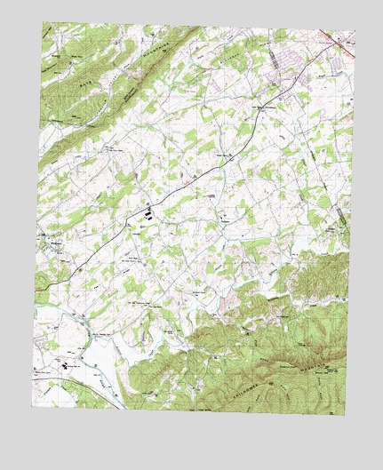
Wildwood, TN USGS Topographic Map
Click on map above to begin viewing in our Map Viewer.

This topographic map contains these locations and features:
Feature Name Type Latitude Longitude GNIS ID View Map
Bays Mountain Country ClubLocaleN35.8481°W83.8227°1323595View Map
Bays Mountain EstatesPopulated PlaceN35.8556°W83.8049°1308054View Map
BayviewPopulated PlaceN35.8570°W83.8124°1308055View Map
Bethel Methodist ChurchChurchN35.8490°W83.7860°1305138View Map
Bethlehem CemeteryCemeteryN35.7881°W83.8113°1642449View Map
Bethlehem Methodist ChurchChurchN35.7884°W83.8121°1305168View Map
Blackoak RidgeRidgeN35.8687°W83.7905°1269355View Map
Blount County Fire Protection District Station 7BuildingN35.8246°W83.8114°2654789View Map
Camp ChilhoweeLocaleN35.7731°W83.7702°1306229View Map
Cedar Grove Baptist ChurchChurchN35.8343°W83.8474°1305766View Map
Cedar Grove CemeteryCemeteryN35.8345°W83.8468°1642453View Map
Chestnut FlatsFlatN35.7659°W83.7743°1280376View Map
Chestnut Flats BranchStreamN35.7812°W83.8038°1280378View Map
Chilhowee MountainRidgeN35.7651°W83.7588°1269457View Map
Cold SpringsPopulated PlaceN35.7576°W83.8116°1646965View Map
Cold Springs CemeteryCemeteryN35.7759°W83.8179°1642460View Map
Cold Springs ChurchChurchN35.7756°W83.8191°1280904View Map
Cold Springs SchoolSchoolN35.7579°W83.8168°1306025View Map
Community School (historical)SchoolN35.8473°W83.7841°1308056View Map
Cowan SpringsPopulated PlaceN35.7504°W83.8091°1314898View Map
Crooked CreekStreamN35.7551°W83.8746°1275391View Map
Davis FordCrossingN35.7779°W83.8538°1314935View Map
Elajay (historical)Populated PlaceN35.7751°W83.8480°1642543View Map
EllejoyPopulated PlaceN35.8095°W83.7552°1326809View Map
Ellejoy Baptist ChurchChurchN35.8104°W83.7552°1642549View Map
Ellejoy CemeteryCemeteryN35.8104°W83.7543°1642465View Map
Ellejoy CreekStreamN35.7740°W83.8516°1283660View Map
Ellejoy ValleyValleyN35.7681°W83.8499°1642550View Map
Eusebia CemeteryCemeteryN35.8326°W83.7993°1642466View Map
Eusebia Presbyterian ChurchChurchN35.8334°W83.7993°1283887View Map
FairfieldPopulated PlaceN35.7634°W83.8682°1308051View Map
Gambles Fort (historical)MilitaryN35.7653°W83.8578°1646813View Map
Headrick CemeteryCemeteryN35.7737°W83.8491°1287278View Map
Heritage High SchoolSchoolN35.7634°W83.8624°1308049View Map
Heritage Vocational SchoolSchoolN35.7645°W83.8616°1308050View Map
Huskey ValleyPopulated PlaceN35.8729°W83.7924°1308053View Map
Into the Wind AirportAirportN35.8269°W83.7760°2717063View Map
Keebles Chapel Baptist ChurchChurchN35.7554°W83.8266°1289938View Map
Keebles Chapel CemeteryCemeteryN35.7556°W83.8260°1642485View Map
Klondike SchoolSchoolN35.8612°W83.8441°1290356View Map
Little Ellejoy CreekStreamN35.7820°W83.8132°1291493View Map
Logans Chapel CemeteryCemeteryN35.8048°W83.8730°1642490View Map
Logans Chapel Methodist ChurchChurchN35.8054°W83.8735°1291820View Map
McCammon CemeteryCemeteryN35.8648°W83.8668°1293110View Map
McTeers Fort (historical)MilitaryN35.8222°W83.8028°1646814View Map
Millstone CreekStreamN35.7920°W83.7841°1294003View Map
Millstone Gap Lookout TowerTowerN35.7651°W83.7585°1647780View Map
Mountcastle Methodist Church (historical)ChurchN35.7981°W83.8346°1642546View Map
Murray GapGapN35.7637°W83.7627°1295142View Map
Nails Creek CemeteryCemeteryN35.8348°W83.8485°1642503View Map
Newcastle Presbyterian ChurchChurchN35.7984°W83.8352°1295455View Map
Newell StationPopulated PlaceN35.8709°W83.7568°1647677View Map
Oak ViewPopulated PlaceN35.7840°W83.8285°1646964View Map
Oak View CemeteryCemeteryN35.7840°W83.8293°1642505View Map
Oak View ChurchChurchN35.7840°W83.8293°1296161View Map
Oak View Community CenterBuildingN35.7845°W83.8280°1310112View Map
Oak View SchoolSchoolN35.7848°W83.8282°1296162View Map
Old ChilhoweePopulated PlaceN35.7829°W83.7671°1646966View Map
Old Chilhowee ChurchChurchN35.7809°W83.7693°1308058View Map
Old Chilhowee SchoolSchoolN35.7806°W83.7702°1296291View Map
Pitner CreekStreamN35.8054°W83.7721°1297736View Map
Pleasant Grove Baptist ChurchChurchN35.7612°W83.8743°1297823View Map
Porter Elementary SchoolSchoolN35.8051°W83.8707°1308052View Map
Porter High School (historical)SchoolN35.8045°W83.8702°1642545View Map
ProspectPopulated PlaceN35.8115°W83.8024°1298572View Map
Prospect Baptist ChurchChurchN35.8137°W83.8018°1642547View Map
Prospect CemeteryCemeteryN35.8137°W83.8010°1642511View Map
Prospect Junior High School (historical)SchoolN35.8131°W83.8013°1642548View Map
ProvidencePopulated PlaceN35.8495°W83.7863°1315775View Map
Red MountainSummitN35.8593°W83.8716°1299075View Map
Rhea CemeteryCemeteryN35.8584°W83.8660°1299268View Map
Rhea GapGapN35.8634°W83.8630°1299272View Map
Rocky BranchStreamN35.7534°W83.8416°1299875View Map
Seymour Air ParkAirportN35.8126°W83.7740°2675549View Map
Seymour Volunteer Fire Department Station 4BuildingN35.8359°W83.7913°2654656View Map
Tarklin Valley ChurchChurchN35.8729°W83.8280°1272131View Map
Tipton HollowValleyN35.7885°W83.7514°1646967View Map
Union TempleChurchN35.7990°W83.8338°1273258View Map
Union Temple CemeteryCemeteryN35.7987°W83.8338°1642521View Map
WildwoodPopulated PlaceN35.8037°W83.8713°1274565View Map
Wildwood Census Designated PlaceCensusN35.7999°W83.8685°2586086View Map
Wildwood Division (historical)CensusN35.8109°W83.8238°1648612View Map
Wildwood School (historical)SchoolN35.8043°W83.8727°1642544View Map
Yankee HillSummitN35.8273°W83.8302°1308057View Map

Note: Coordinates in the location and feature list above are referenced to NAD83 datum.


Copyright (C) 2008-2024 Ryan Niemi / Sunset Dynamics ... All Rights Reserved