TopoQuest Logo
Do you find TopoQuest useful?
Help keep TopoQuest running and adding new maps/features by donating!
Bitcoin:  19c7KJd3qBynnjoSw5npx9KScwjBe4ifkT
Litecoin:  LXs6TkuXGGXo1vDsWCkWVdjQX94eUKd6ui
Home View Maps Find Maps Find Places Resources & Links


Kirkland, Georgia Topographic Map

USGS Map Title: Kirkland, GA
USGS Map MRC: 31082C8
DRG (GeoTIFF) Download: o31082c8.tif


Neighboring USGS Topographic Map Quads:


  Lax, GA  
31083D1
 

  Mora, GA  
31082D8
 

  Douglas South, GA  
31082D7
 

  Willacoochee, GA  
31083C1
 

  Kirkland, GA  
31082C8
 

  Pearson, GA  
31082C7
 

  Hastings Fish Pond, GA  
31083B1
 

  Henderson Still, GA  
31082B8
 

  Sandy Bottom, GA  
31082B7


Map MRC Location:

N32°
W83°
N32°
W82°
H8 H7 H6 H5 H4 H3 H2 H1
G8 G7 G6 G5 G4 G3 G2 G1
F8 F7 F6 F5 F4 F3 F2 F1
E8 E7 E6 E5 E4 E3 E2 E1
D8 D7 D6 D5 D4 D3 D2 D1
C8 C7 C6 C5 C4 C3 C2 C1
B8 B7 B6 B5 B4 B3 B2 B1
A8 A7 A6 A5 A4 A3 A2 A1
N31°
W83°
N31°
W82°

Kirkland, GA USGS 1:24K Topographic Map Preview:
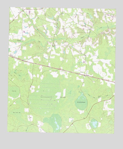
Kirkland, GA USGS Topographic Map
Click on map above to begin viewing in our Map Viewer.

This topographic map contains these locations and features:
Feature Name Type Latitude Longitude GNIS ID View Map
Antioch ChurchChurchN31.3374°W82.9465°310564View Map
Atkinson CountyCivilN31.2971°W82.8800°345784View Map
Bethel ChurchChurchN31.2652°W82.9093°311162View Map
Camp BaySwampN31.2910°W82.9939°312192View Map
Crossroads ChurchChurchN31.3571°W82.9096°313176View Map
Dark BayStreamN31.3441°W82.9524°313307View Map
Hog Creek BaySwampN31.2690°W82.9857°315505View Map
KirklandPopulated PlaceN31.3083°W82.9082°316471View Map
Kirkland ChurchChurchN31.3102°W82.9110°345789View Map
Kirkland MillpondLakeN31.2810°W82.9138°316477View Map
Kirkland Post Office (historical)Post OfficeN31.3077°W82.9101°345790View Map
LeliatonPopulated PlaceN31.3249°W82.9932°316762View Map
Mill CreekStreamN31.3549°W82.8935°318215View Map
Pearson DivisionCivilN31.2851°W82.8792°1936464View Map
Reedy CreekStreamN31.3441°W82.9393°321459View Map
Roundabout SwampSwampN31.2868°W82.9458°321963View Map
Smith PondLakeN31.3080°W82.9888°323146View Map
Sunnyside ChurchChurchN31.3544°W82.9038°323764View Map
Vickers LakeReservoirN31.3298°W82.9922°338054View Map
Vickers Lake DamDamN31.3319°W82.9915°338053View Map
WWFP-FM (Pearson)TowerN31.3624°W82.9351°352752View Map

Note: Coordinates in the location and feature list above are referenced to NAD83 datum.


Copyright (C) 2008-2025 Ryan Niemi / Sunset Dynamics ... All Rights Reserved