TopoQuest Logo
Do you find TopoQuest useful?
Help keep TopoQuest running and adding new maps/features by donating!
Bitcoin:  19c7KJd3qBynnjoSw5npx9KScwjBe4ifkT
Litecoin:  LXs6TkuXGGXo1vDsWCkWVdjQX94eUKd6ui
Home View Maps Find Maps Find Places Resources & Links


Pearson, Georgia Topographic Map

USGS Map Title: Pearson, GA
USGS Map MRC: 31082C7
DRG (GeoTIFF) Download: o31082c7.tif


Neighboring USGS Topographic Map Quads:


  Mora, GA  
31082D8
 

  Douglas South, GA  
31082D7
 

  Wilsonville, GA  
31082D6
 

  Kirkland, GA  
31082C8
 

  Pearson, GA  
31082C7
 

  Axson, GA  
31082C6
 

  Henderson Still, GA  
31082B8
 

  Sandy Bottom, GA  
31082B7
 

  Cogdell, GA  
31082B6


Map MRC Location:

N32°
W83°
N32°
W82°
H8 H7 H6 H5 H4 H3 H2 H1
G8 G7 G6 G5 G4 G3 G2 G1
F8 F7 F6 F5 F4 F3 F2 F1
E8 E7 E6 E5 E4 E3 E2 E1
D8 D7 D6 D5 D4 D3 D2 D1
C8 C7 C6 C5 C4 C3 C2 C1
B8 B7 B6 B5 B4 B3 B2 B1
A8 A7 A6 A5 A4 A3 A2 A1
N31°
W83°
N31°
W82°

Pearson, GA USGS 1:24K Topographic Map Preview:
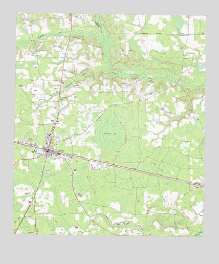
Pearson, GA USGS Topographic Map
Click on map above to begin viewing in our Map Viewer.

This topographic map contains these locations and features:
Feature Name Type Latitude Longitude GNIS ID View Map
Atkinson County CourthouseBuildingN31.2955°W82.8535°345785View Map
Atkinson County JailBuildingN31.2958°W82.8535°2734218View Map
Atkinson County Junior High SchoolSchoolN31.2969°W82.8615°345786View Map
Atkinson County Sheriff's OfficeBuildingN31.2958°W82.8535°2733789View Map
Atkinson Volunteer Fire Department Station 2BuildingN31.2967°W82.8522°2603965View Map
City of PearsonCivilN31.2970°W82.8544°2404496View Map
Fales ChurchChurchN31.3749°W82.7610°355773View Map
Kight CemeteryCemeteryN31.3505°W82.7646°316411View Map
Mount Pleasant ChurchChurchN31.3619°W82.8360°318831View Map
Mount Zion ChurchChurchN31.3210°W82.7585°318946View Map
PearsonPopulated PlaceN31.2977°W82.8524°332626View Map
Pearson Elementary SchoolSchoolN31.2949°W82.8513°345791View Map
Pearson Police DeptBuildingN31.2960°W82.8524°2733712View Map
Pearson Post OfficePost OfficeN31.2970°W82.8517°345796View Map
Pudding CreekStreamN31.3594°W82.8165°321214View Map
Refuge ChurchChurchN31.3271°W82.8443°321489View Map
Ricketson BaySwampN31.3083°W82.8122°321588View Map
Sweetwater ChurchChurchN31.3277°W82.8446°323826View Map
Sweetwater CreekStreamN31.3427°W82.8110°323830View Map
Union Hill ChurchChurchN31.2571°W82.8015°324564View Map

Note: Coordinates in the location and feature list above are referenced to NAD83 datum.


Copyright (C) 2008-2025 Ryan Niemi / Sunset Dynamics ... All Rights Reserved