TopoQuest Logo
Do you find TopoQuest useful?
Help keep TopoQuest running and adding new maps/features by donating!
Bitcoin:  19c7KJd3qBynnjoSw5npx9KScwjBe4ifkT
Litecoin:  LXs6TkuXGGXo1vDsWCkWVdjQX94eUKd6ui
Home View Maps Find Maps Find Places Resources & Links


Knights Landing, California Topographic Map

USGS Map Title: Knights Landing, CA
USGS Map MRC: 38121G6
DRG (GeoTIFF) Download: o38121g6.tif


Neighboring USGS Topographic Map Quads:


  Kirkville, CA  
38121H7
 

  Sutter Causeway, CA  
38121H6
 

  Nicolaus, CA  
38121H5
 

  Eldorado Bend, CA  
38121G7
 

  Knights Landing, CA  
38121G6
 

  Verona, CA  
38121G5
 

  Woodland, CA  
38121F7
 

  Grays Bend, CA  
38121F6
 

  Taylor Monument, CA  
38121F5


Map MRC Location:

N39°
W122°
N39°
W121°
H8 H7 H6 H5 H4 H3 H2 H1
G8 G7 G6 G5 G4 G3 G2 G1
F8 F7 F6 F5 F4 F3 F2 F1
E8 E7 E6 E5 E4 E3 E2 E1
D8 D7 D6 D5 D4 D3 D2 D1
C8 C7 C6 C5 C4 C3 C2 C1
B8 B7 B6 B5 B4 B3 B2 B1
A8 A7 A6 A5 A4 A3 A2 A1
N38°
W122°
N38°
W121°

Knights Landing, CA USGS 1:24K Topographic Map Preview:
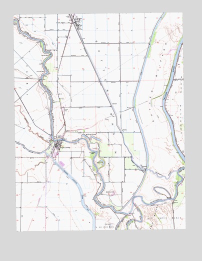
Knights Landing, CA USGS Topographic Map
Click on map above to begin viewing in our Map Viewer.

This topographic map contains these locations and features:
Feature Name Type Latitude Longitude GNIS ID View Map
Bob's Flying Service IncAirportN38.8310°W121.7183°1653581View Map
Coon LakeLakeN38.7526°W121.6815°221513View Map
CunardPopulated PlaceN38.8138°W121.6858°1658358View Map
EnsleyPopulated PlaceN38.8074°W121.6727°1658505View Map
Fourmile BendBendN38.8416°W121.7283°223751View Map
Fremont WeirDamN38.7639°W121.6488°223893View Map
Fremont Weir State Wildlife AreaParkN38.7635°W121.6555°1703156View Map
Grafton Elementary SchoolSchoolN38.7982°W121.7205°1703159View Map
Horseshoe LakeLakeN38.7705°W121.6794°225645View Map
Kanaka CutoffCanalN38.7674°W121.6383°226418View Map
KarnakPopulated PlaceN38.7849°W121.6555°1658884View Map
Knights LandingPopulated PlaceN38.7996°W121.7183°226652View Map
Knights Landing Branch Yolo County LibraryBuildingN38.8005°W121.7180°1703173View Map
Knights Landing Census Designated PlaceCensusN38.7980°W121.7176°2583047View Map
Knights Landing Fire DepartmentBuildingN38.7990°W121.7221°2624415View Map
Knights Landing Post OfficePost OfficeN38.8018°W121.7181°1703174View Map
Knights Landing Ridge CutCanalN38.7652°W121.7016°226653View Map
Knights SchoolSchoolN38.8038°W121.7169°226654View Map
MarchantPopulated PlaceN38.8230°W121.6800°1659055View Map
Mary LakeLakeN38.7902°W121.6873°228193View Map
McGriff LakesLakeN38.8034°W121.6933°228375View Map
Portuguese BendBendN38.7949°W121.6925°230965View Map
Railroad BendBendN38.8516°W121.7252°231173View Map
RobbinsPopulated PlaceN38.8702°W121.7064°231673View Map
Robbins Census Designated PlaceCensusN38.8671°W121.7056°2583123View Map
Robbins Elementary SchoolSchoolN38.8715°W121.7017°1703420View Map
Robbins Post OfficePost OfficeN38.8707°W121.7048°1703421View Map
Robbins Sutter Basin Fire Protection DistrictBuildingN38.8698°W121.7025°2622051View Map
Sacramento SloughGutN38.7802°W121.6413°232084View Map
Saint Paul Catholic ChurchChurchN38.7991°W121.7211°1703465View Map
Sunrise Dusters AirportAirportN38.8709°W121.7085°1653580View Map
Victor BendBendN38.8707°W121.7494°237065View Map
Wild Irishman BendBendN38.7660°W121.6902°237766View Map

Note: Coordinates in the location and feature list above are referenced to NAD83 datum.


Copyright (C) 2008-2025 Ryan Niemi / Sunset Dynamics ... All Rights Reserved