TopoQuest Logo
Do you find TopoQuest useful?
Help keep TopoQuest running and adding new maps/features by donating!
Bitcoin:  19c7KJd3qBynnjoSw5npx9KScwjBe4ifkT
Litecoin:  LXs6TkuXGGXo1vDsWCkWVdjQX94eUKd6ui
Home View Maps Find Maps Find Places Resources & Links


Kountze North, Texas Topographic Map

USGS Map Title: Kountze North, TX
USGS Map MRC: 30094D3
DRG (GeoTIFF) Download: o30094d3.tif


Neighboring USGS Topographic Map Quads:


  Warren, TX  
30094E4
 

  Hicksbaugh, TX  
30094E3
 

  Fred, TX  
30094E2
 

  Village Mills, TX  
30094D4
 

  Kountze North, TX  
30094D3
 

  Deserter Baygall, TX  
30094D2
 

  Kountze SW, TX  
30094C4
 

  Kountze South, TX  
30094C3
 

  Silsbee, TX  
30094C2


Map MRC Location:

N31°
W95°
N31°
W94°
H8 H7 H6 H5 H4 H3 H2 H1
G8 G7 G6 G5 G4 G3 G2 G1
F8 F7 F6 F5 F4 F3 F2 F1
E8 E7 E6 E5 E4 E3 E2 E1
D8 D7 D6 D5 D4 D3 D2 D1
C8 C7 C6 C5 C4 C3 C2 C1
B8 B7 B6 B5 B4 B3 B2 B1
A8 A7 A6 A5 A4 A3 A2 A1
N30°
W95°
N30°
W94°

Kountze North, TX USGS 1:24K Topographic Map Preview:
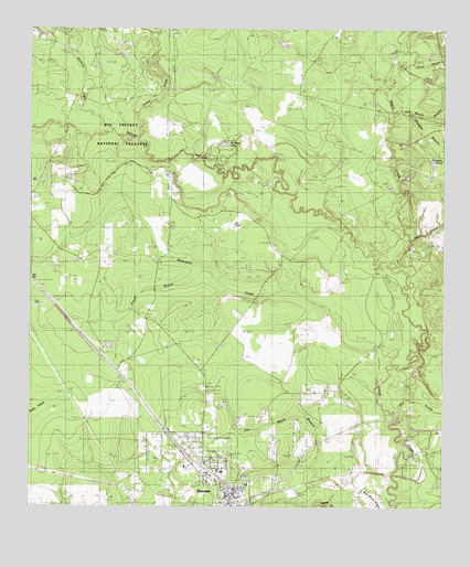
Kountze North, TX USGS Topographic Map
Click on map above to begin viewing in our Map Viewer.

This topographic map contains these locations and features:
Feature Name Type Latitude Longitude GNIS ID View Map
Beaumont CreekStreamN30.4088°W94.2699°1351715View Map
Beech CreekStreamN30.4388°W94.2635°1351779View Map
Big Thicket - Kirby Nature TrailTrailN30.4677°W94.3444°2032998View Map
Camp MatigwaLocaleN30.4419°W94.2569°1353649View Map
Daniels CemeteryCemeteryN30.3822°W94.3038°1355635View Map
Dry CreekStreamN30.3988°W94.2641°1356314View Map
East Village Mills Oil FieldOilfieldN30.4983°W94.3699°1356727View Map
Fountain PondLakeN30.4652°W94.2534°1357624View Map
Hester BranchStreamN30.4669°W94.3010°1359093View Map
Hickory CreekStreamN30.4738°W94.3502°1359116View Map
Kountze City HallBuildingN30.3841°W94.3209°2753245View Map
Mason BranchStreamN30.4455°W94.2599°1362253View Map
McNeely CemeteryCemeteryN30.4616°W94.3310°1362530View Map
McNeely LakeLakeN30.4698°W94.3169°1362532View Map
Mundine BranchStreamN30.4785°W94.2619°1363482View Map
Nixon BranchStreamN30.4916°W94.2588°1363919View Map
Olive CemeteryCemeteryN30.4052°W94.3438°1364522View Map
Pea Monk BranchStreamN30.3763°W94.2835°1364916View Map
Pinoak BranchStreamN30.4366°W94.3219°1365327View Map
Providence ChurchChurchN30.4577°W94.3724°1365818View Map
Sam Moore BranchStreamN30.4785°W94.2652°1367464View Map
Turkey CreekStreamN30.4716°W94.3421°1370237View Map
William W. Hart CemeteryCemeteryN30.4412°W94.3511°1365812View Map

Note: Coordinates in the location and feature list above are referenced to NAD83 datum.


Copyright (C) 2008-2025 Ryan Niemi / Sunset Dynamics ... All Rights Reserved