TopoQuest Logo
Do you find TopoQuest useful?
Help keep TopoQuest running and adding new maps/features by donating!
Bitcoin:  19c7KJd3qBynnjoSw5npx9KScwjBe4ifkT
Litecoin:  LXs6TkuXGGXo1vDsWCkWVdjQX94eUKd6ui
Home View Maps Find Maps Find Places Resources & Links


Kountze South, Texas Topographic Map

USGS Map Title: Kountze South, TX
USGS Map MRC: 30094C3
DRG (GeoTIFF) Download: o30094c3.tif


Neighboring USGS Topographic Map Quads:


  Village Mills, TX  
30094D4
 

  Kountze North, TX  
30094D3
 

  Deserter Baygall, TX  
30094D2
 

  Kountze SW, TX  
30094C4
 

  Kountze South, TX  
30094C3
 

  Silsbee, TX  
30094C2
 

  Sour Lake, TX  
30094B4
 

  Bevil Oaks, TX  
30094B3
 

  Voth, TX  
30094B2


Map MRC Location:

N31°
W95°
N31°
W94°
H8 H7 H6 H5 H4 H3 H2 H1
G8 G7 G6 G5 G4 G3 G2 G1
F8 F7 F6 F5 F4 F3 F2 F1
E8 E7 E6 E5 E4 E3 E2 E1
D8 D7 D6 D5 D4 D3 D2 D1
C8 C7 C6 C5 C4 C3 C2 C1
B8 B7 B6 B5 B4 B3 B2 B1
A8 A7 A6 A5 A4 A3 A2 A1
N30°
W95°
N30°
W94°

Kountze South, TX USGS 1:24K Topographic Map Preview:
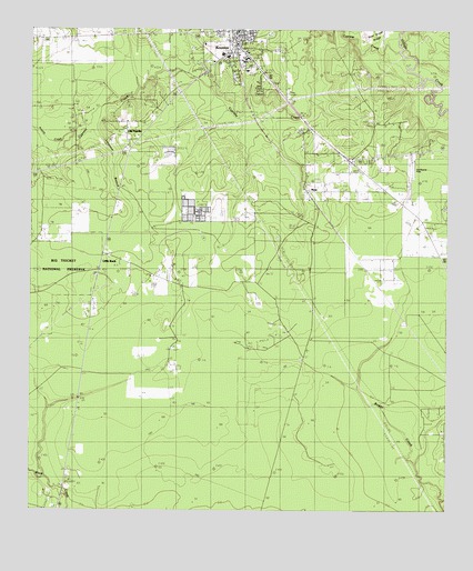
Kountze South, TX USGS Topographic Map
Click on map above to begin viewing in our Map Viewer.

This topographic map contains these locations and features:
Feature Name Type Latitude Longitude GNIS ID View Map
Bear Grass RidgeRidgeN30.3747°W94.2721°1330234View Map
City of KountzeCivilN30.3725°W94.3160°2411558View Map
Cypress CreekStreamN30.3699°W94.2655°1373328View Map
Hardin County Constable's Office Precinct 1BuildingN30.3682°W94.3161°2751307View Map
Hardin County Constable's Office Precinct 2BuildingN30.3682°W94.3161°2751308View Map
Hardin County Constable's Office Precinct 3BuildingN30.3682°W94.3161°2751309View Map
Hardin County Highway PatrolBuildingN30.3684°W94.3156°2375819View Map
Hardin County JailBuildingN30.3682°W94.3163°2738751View Map
Hardin County Sheriff's DepartmentBuildingN30.3682°W94.3161°2751310View Map
Hawthorne FieldAirportN30.3383°W94.2583°1387027View Map
KountzePopulated PlaceN30.3716°W94.3124°1374401View Map
Kountze DivisionCivilN30.3730°W94.3533°1938892View Map
Kountze Lookout TowerTowerN30.3363°W94.3710°1384407View Map
Kountze Police DepartmentBuildingN30.3705°W94.3149°2375915View Map
Kountze Post OfficePost OfficeN30.3675°W94.3083°2732039View Map
Kountze Volunteer Fire Department Station 1BuildingN30.3750°W94.3123°2334510View Map
Little Rock ChurchChurchN30.3116°W94.3557°1340164View Map
Longston BranchStreamN30.3499°W94.3574°1340541View Map
NonaPopulated PlaceN30.3335°W94.2919°1378759View Map
Nona Mills Oil FieldOilfieldN30.3658°W94.3352°1342655View Map
Texas Forest Service Kountze OfficeBuildingN30.3493°W94.2905°2655623View Map
Wildwood Heritage Society MuseumBuildingN30.3738°W94.3599°2014096View Map

Note: Coordinates in the location and feature list above are referenced to NAD83 datum.


Copyright (C) 2008-2024 Ryan Niemi / Sunset Dynamics ... All Rights Reserved