TopoQuest Logo
Do you find TopoQuest useful?
Help keep TopoQuest running and adding new maps/features by donating!
Bitcoin:  19c7KJd3qBynnjoSw5npx9KScwjBe4ifkT
Litecoin:  LXs6TkuXGGXo1vDsWCkWVdjQX94eUKd6ui
Home View Maps Find Maps Find Places Resources & Links


Krumbo Ridge, Oregon Topographic Map

USGS Map Title: Krumbo Ridge, OR
USGS Map MRC: 42118H6
DRG (GeoTIFF) Download: o42118h6.tif


Neighboring USGS Topographic Map Quads:


  Diamond Swamp, OR  
43118A7
 

  Diamond, OR  
43118A6
 

  Happy Valley, OR  
43118A5
 

  Krumbo Reservoir, OR  
42118H7
 

  Krumbo Ridge, OR  
42118H6
 

  Poison Springs, OR  
42118H5
 

  Page Springs, OR  
42118G7
 

  McCoy Ridge, OR  
42118G6
 

  Big Pasture Creek, OR  
42118G5


Map MRC Location:

N43°
W119°
N43°
W118°
H8 H7 H6 H5 H4 H3 H2 H1
G8 G7 G6 G5 G4 G3 G2 G1
F8 F7 F6 F5 F4 F3 F2 F1
E8 E7 E6 E5 E4 E3 E2 E1
D8 D7 D6 D5 D4 D3 D2 D1
C8 C7 C6 C5 C4 C3 C2 C1
B8 B7 B6 B5 B4 B3 B2 B1
A8 A7 A6 A5 A4 A3 A2 A1
N42°
W119°
N42°
W118°

Krumbo Ridge, OR USGS 1:24K Topographic Map Preview:
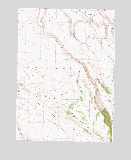
Krumbo Ridge, OR USGS Topographic Map
Click on map above to begin viewing in our Map Viewer.

This topographic map contains these locations and features:
Feature Name Type Latitude Longitude GNIS ID View Map
Antler SeepSpringN42.9190°W118.6649°1638571View Map
Basin ReservoirReservoirN42.9541°W118.7048°1638577View Map
Bird Fence Reservoir Number OneReservoirN42.9446°W118.7356°1638573View Map
Bird Fence Reservoir Number TwoReservoirN42.9350°W118.7369°1638572View Map
Frazier Lake WaterholeReservoirN42.9207°W118.6867°1638574View Map
Harold Otley PlaceLocaleN42.9485°W118.6269°1638567View Map
Hidden SeepSpringN42.9211°W118.6871°1121793View Map
Krumbo ButteSummitN42.9207°W118.7469°1122845View Map
Krumbo MountainRidgeN42.8843°W118.6716°1122848View Map
Krumbo Mountain ReservoirReservoirN42.8780°W118.6806°1638566View Map
Krumbo RidgeRidgeN42.9043°W118.7102°1122850View Map
Krumbo SpringsSpringN42.9140°W118.7395°1122852View Map
Moon Hill LakebedFlatN42.9118°W118.6788°1638575View Map
Moon Hill ReservoirReservoirN42.8932°W118.6592°1638576View Map
Ruby SpringsSpringN42.9516°W118.6850°1126352View Map
Ruby Springs WellWellN42.9860°W118.7330°1638564View Map
Section Nineteen ReservoirReservoirN42.9477°W118.6876°1638568View Map
Thompson RanchLocaleN42.9874°W118.7219°1638563View Map
Whiskey CreekStreamN42.9510°W118.6724°1128937View Map
Whiskey Creek ReservoirReservoirN42.9252°W118.6695°1638570View Map
Whiskey Creek Reservoir Number TwoReservoirN42.9379°W118.6699°1638569View Map
Witzel RanchLocaleN42.9996°W118.7163°1638565View Map

Note: Coordinates in the location and feature list above are referenced to NAD83 datum.


Copyright (C) 2008-2025 Ryan Niemi / Sunset Dynamics ... All Rights Reserved