TopoQuest Logo
Do you find TopoQuest useful?
Help keep TopoQuest running and adding new maps/features by donating!
Bitcoin:  19c7KJd3qBynnjoSw5npx9KScwjBe4ifkT
Litecoin:  LXs6TkuXGGXo1vDsWCkWVdjQX94eUKd6ui
Home View Maps Find Maps Find Places Resources & Links


Kure Beach, North Carolina Topographic Map

USGS Map Title: Kure Beach, NC
USGS Map MRC: 33077H8
DRG (GeoTIFF) Download: o33077h8.tif


Neighboring USGS Topographic Map Quads:


  Funston, NC  
34078A1
 

  Carolina Beach, NC  
34077A8


  Southport, NC  
33078H1
 

  Kure Beach, NC  
33077H8


Map MRC Location:

N34°
W78°
N34°
W77°
H8 H7 H6 H5 H4 H3 H2 H1
G8 G7 G6 G5 G4 G3 G2 G1
F8 F7 F6 F5 F4 F3 F2 F1
E8 E7 E6 E5 E4 E3 E2 E1
D8 D7 D6 D5 D4 D3 D2 D1
C8 C7 C6 C5 C4 C3 C2 C1
B8 B7 B6 B5 B4 B3 B2 B1
A8 A7 A6 A5 A4 A3 A2 A1
N33°
W78°
N33°
W77°

Kure Beach, NC USGS 1:24K Topographic Map Preview:
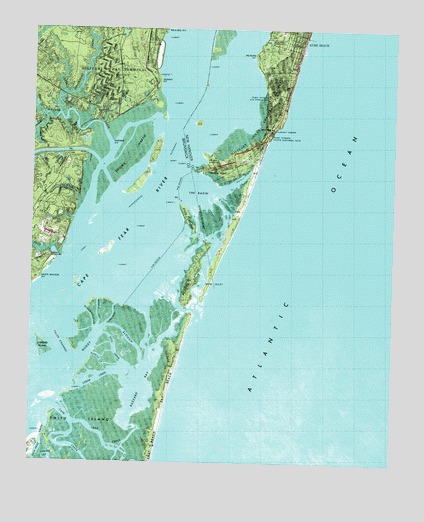
Kure Beach, NC USGS Topographic Map
Click on map above to begin viewing in our Map Viewer.

This topographic map contains these locations and features:
Feature Name Type Latitude Longitude GNIS ID View Map
Bald Head CreekStreamN33.8868°W77.9942°1018916View Map
Bay BeachBeachN33.8955°W77.9522°980643View Map
Bay CreekGutN33.8816°W77.9739°980651View Map
Bowensville CreekGutN33.9168°W77.9786°981770View Map
Burriss CreekGutN33.9055°W77.9755°982306View Map
Buzzard BayBayN33.8963°W77.9617°982345View Map
Cape CreekStreamN33.8910°W77.9900°982614View Map
Cedar CreekGutN33.8991°W77.9764°982806View Map
Corncake Inlet (historical)ChannelN33.9191°W77.9444°1005419View Map
Deep Water PointCapeN33.9282°W77.9964°984104View Map
False ChannelChannelN33.9099°W77.9892°984997View Map
Federal PointCapeN33.9591°W77.9411°985027View Map
Fishing CreekStreamN33.9816°W77.9892°985112View Map
Fort Fisher State Historic SiteParkN33.9699°W77.9180°985320View Map
Fort Fisher State Recreation AreaParkN33.9583°W77.9292°2374753View Map
Governors CreekStreamN33.9755°W77.9905°985875View Map
Gum Log BranchStreamN33.9705°W77.9986°986219View Map
Horseshoe ShoalBarN33.9488°W77.9697°1005431View Map
Horseshoe Shoal Channel RangeChannelN33.9616°W77.9530°1008324View Map
Kure BeachPopulated PlaceN33.9968°W77.9072°1021071View Map
Kure Beach Police DepartmentBuildingN34.0000°W77.9103°2131072View Map
Kure Beach Volunteer Fire DepartmentBuildingN33.9998°W77.9100°2638291View Map
Kure Beach Wastewater Treatment PlantLocaleN33.9969°W77.9190°2506006View Map
Lower Midnight Channel RangeChannelN33.9991°W77.9428°1008360View Map
Middle CreekGutN33.9185°W77.9767°989769View Map
Midnight ShoalBarN33.9932°W77.9492°1005430View Map
Muddy SloughGutN33.9124°W77.9753°990767View Map
Nancys CreekStreamN33.9752°W77.9955°990858View Map
New Inlet (historical)BayN33.9271°W77.9403°991046View Map
Nigis CreekStreamN33.9763°W77.9978°991152View Map
North Carolina Aquarium at Fort FisherBuildingN33.9628°W77.9259°2505976View Map
Peters PointCapeN33.9930°W77.9236°992092View Map
Price CreekStreamN33.9335°W77.9903°992809View Map
Prices Creek LighthouseLocaleN33.9355°W77.9905°1940333View Map
Reaves Point Channel RangeChannelN33.9771°W77.9475°1025015View Map
Sheephead RockPopulated PlaceN33.9402°W77.9136°1005097View Map
Shellbed CreekGutN33.9174°W77.9714°994645View Map
Shellbed IslandIslandN33.9102°W77.9825°1005432View Map
Smith IslandIslandN33.8841°W77.9803°994982View Map
Snow Marsh Channel RangeChannelN33.9410°W77.9728°1008323View Map
Snows MarshSwampN33.9644°W77.9657°995077View Map
Snows PointCapeN33.9680°W77.9722°995078View Map
Still CreekGutN33.9080°W77.9708°995513View Map
Striking IslandIslandN33.9068°W77.9953°995614View Map
Sunny PointCapeN33.9852°W77.9564°995699View Map
The BasinBayN33.9535°W77.9430°995955View Map
The RocksDamN33.9346°W77.9544°996007View Map
ThorofareChannelN33.8971°W77.9919°1005429View Map
Town of Kure BeachCivilN33.9989°W77.9078°2405961View Map
Walden CreekStreamN33.9493°W77.9803°996687View Map
Zekes IslandIslandN33.9457°W77.9461°997747View Map

Note: Coordinates in the location and feature list above are referenced to NAD83 datum.


Copyright (C) 2008-2025 Ryan Niemi / Sunset Dynamics ... All Rights Reserved