TopoQuest Logo
Do you find TopoQuest useful?
Help keep TopoQuest running and adding new maps/features by donating!
Bitcoin:  19c7KJd3qBynnjoSw5npx9KScwjBe4ifkT
Litecoin:  LXs6TkuXGGXo1vDsWCkWVdjQX94eUKd6ui
Home View Maps Find Maps Find Places Resources & Links


Funston, North Carolina Topographic Map

USGS Map Title: Funston, NC
USGS Map MRC: 34078A1
DRG (GeoTIFF) Download: o34078a1.tif


Neighboring USGS Topographic Map Quads:


  Lewis Swamp, NC  
34078B2
 

  Winnabow, NC  
34078B1
 

  Wilmington, NC  
34077B8
 

  Bolivia, NC  
34078A2
 

  Funston, NC  
34078A1
 

  Carolina Beach, NC  
34077A8
 

  Lockwoods Folly, NC  
33078H2
 

  Southport, NC  
33078H1
 

  Kure Beach, NC  
33077H8


Map MRC Location:

N35°
W79°
N35°
W78°
H8 H7 H6 H5 H4 H3 H2 H1
G8 G7 G6 G5 G4 G3 G2 G1
F8 F7 F6 F5 F4 F3 F2 F1
E8 E7 E6 E5 E4 E3 E2 E1
D8 D7 D6 D5 D4 D3 D2 D1
C8 C7 C6 C5 C4 C3 C2 C1
B8 B7 B6 B5 B4 B3 B2 B1
A8 A7 A6 A5 A4 A3 A2 A1
N34°
W79°
N34°
W78°

Funston, NC USGS 1:24K Topographic Map Preview:
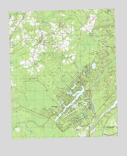
Funston, NC USGS Topographic Map
Click on map above to begin viewing in our Map Viewer.

This topographic map contains these locations and features:
Feature Name Type Latitude Longitude GNIS ID View Map
Allen Creek BridgeBridgeN34.0257°W78.0636°980108View Map
Bell SwampStreamN34.1193°W78.0783°980948View Map
Blue Gill PondLakeN34.0221°W78.0386°1023446View Map
Boiling SpringSpringN34.0463°W78.0350°1004751View Map
Boiling Spring LakeReservoirN34.0464°W78.0368°998084View Map
Boiling Spring Lake DamDamN34.0468°W78.0364°998083View Map
Boiling Spring LakesPopulated PlaceN34.0305°W78.0672°1004747View Map
Boiling Spring Lakes Police DepartmentBuildingN34.0315°W78.0676°2130841View Map
Boiling Spring Lakes Volunteer Fire Department Station 1BuildingN34.0323°W78.0676°2638627View Map
Boiling Spring Lakes Volunteer Fire Department Station 2BuildingN34.0647°W78.0311°2639221View Map
Boiling Spring Lakes Volunteer Fire Department Station 3BuildingN34.0284°W78.0355°2638111View Map
Brunswick County Emergency Medical ServicesBuildingN34.0320°W78.0683°2720623View Map
Brunswick StationLocaleN34.1166°W78.1186°982049View Map
Christian ChapelChurchN34.1196°W78.1083°983169View Map
City of Boiling Spring LakesCivilN34.0322°W78.0681°2403889View Map
Crystal LakeLakeN34.0420°W78.0546°1023433View Map
Eastend LakeLakeN34.0272°W78.0287°1023434View Map
Forest LakeLakeN34.0408°W78.0364°1023435View Map
Frink LakeLakeN34.0642°W78.0328°1004754View Map
FunstonPopulated PlaceN34.1010°W78.0269°1006212View Map
Green LakeLakeN34.0303°W78.0429°1023436View Map
Harper LakeLakeN34.0663°W78.0355°1004750View Map
Harris SwampStreamN34.1082°W78.0842°986457View Map
Hickman BranchStreamN34.0954°W78.0761°986683View Map
Kaziah LakeLakeN34.0627°W78.0376°1023450View Map
Lake BuisLakeN34.0176°W78.0478°1023432View Map
Lake HastieLakeN34.0220°W78.0425°1004752View Map
Lake MarshLakeN34.0336°W78.0320°1023437View Map
Lake MiddletonLakeN34.0241°W78.0390°1023439View Map
Lake ReavesLakeN34.0199°W78.0413°1023448View Map
Lebanon ChurchChurchN34.1013°W78.0264°1004745View Map
Lewis BridgeBridgeN34.0518°W78.1233°988376View Map
Meadow LakeLakeN34.0306°W78.0330°1023438View Map
Military Ocean Terminal Sunny PointMilitaryN34.0024°W78.0097°2512293View Map
Mill CreekPopulated PlaceN34.0985°W78.0864°1021451View Map
Mill Creek ChurchChurchN34.0960°W78.0897°1004742View Map
Mirror LakeLakeN34.0297°W78.0293°1004753View Map
Moore CreekStreamN34.0093°W78.0289°990174View Map
New Hope ChurchChurchN34.0982°W78.0225°1004744View Map
North LakeReservoirN34.0443°W78.0555°998082View Map
North Lake DamDamN34.0435°W78.0530°998081View Map
Paradise LakeLakeN34.0279°W78.0374°1023440View Map
Patricia LakeLakeN34.0476°W78.0434°1023441View Map
Peace Memorial ChurchChurchN34.1232°W78.1058°1004743View Map
Pine LakeReservoirN34.0351°W78.0642°998080View Map
Pine Lake DamDamN34.0335°W78.0630°998079View Map
Pretty PondLakeN34.0701°W78.0261°992798View Map
Rice CreekStreamN34.1207°W78.0719°1004746View Map
Seminole LakeLakeN34.0300°W78.0349°1023442View Map
Shadow LakeLakeN34.0362°W78.0375°1023443View Map
Silver LakeLakeN34.0364°W78.0355°1023444View Map
South Brunswick High SchoolSchoolN34.0096°W78.0442°1004749View Map
South Brunswick Middle SchoolSchoolN34.0086°W78.0474°1004748View Map
Spring LakeLakeN34.0499°W78.0504°1023447View Map
Swain BranchStreamN34.0860°W78.0761°995736View Map
Tate LakeLakeN34.0372°W78.0441°1023445View Map
Twin LakesLakeN34.0360°W78.0364°1023449View Map
Willet BranchStreamN34.1035°W78.0783°997349View Map
Woods PondsLakeN34.0252°W78.0392°997612View Map

Note: Coordinates in the location and feature list above are referenced to NAD83 datum.


Copyright (C) 2008-2025 Ryan Niemi / Sunset Dynamics ... All Rights Reserved