TopoQuest Logo
Do you find TopoQuest useful?
Help keep TopoQuest running and adding new maps/features by donating!
Bitcoin:  19c7KJd3qBynnjoSw5npx9KScwjBe4ifkT
Litecoin:  LXs6TkuXGGXo1vDsWCkWVdjQX94eUKd6ui
Home View Maps Find Maps Find Places Resources & Links


Southport, North Carolina Topographic Map

USGS Map Title: Southport, NC
USGS Map MRC: 33078H1
DRG (GeoTIFF) Download: o33078h1.tif


Neighboring USGS Topographic Map Quads:


  Bolivia, NC  
34078A2
 

  Funston, NC  
34078A1
 

  Carolina Beach, NC  
34077A8
 

  Lockwoods Folly, NC  
33078H2
 

  Southport, NC  
33078H1
 

  Kure Beach, NC  
33077H8


Map MRC Location:

N34°
W79°
N34°
W78°
H8 H7 H6 H5 H4 H3 H2 H1
G8 G7 G6 G5 G4 G3 G2 G1
F8 F7 F6 F5 F4 F3 F2 F1
E8 E7 E6 E5 E4 E3 E2 E1
D8 D7 D6 D5 D4 D3 D2 D1
C8 C7 C6 C5 C4 C3 C2 C1
B8 B7 B6 B5 B4 B3 B2 B1
A8 A7 A6 A5 A4 A3 A2 A1
N33°
W79°
N33°
W78°

Southport, NC USGS 1:24K Topographic Map Preview:
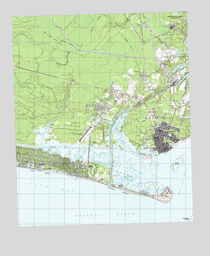
Southport, NC USGS Topographic Map
Click on map above to begin viewing in our Map Viewer.

This topographic map contains these locations and features:
Feature Name Type Latitude Longitude GNIS ID View Map
Baldhead CaswellChannelN33.8855°W78.0075°1008278View Map
Barnes BluffCliffN33.9232°W78.0689°1006415View Map
Battery IslandIslandN33.9093°W78.0105°980627View Map
Battery Island ChannelChannelN33.9066°W78.0155°1008280View Map
Beaverdam CreekStreamN33.9224°W78.1075°980832View Map
Beaverdam SwampStreamN33.9393°W78.0919°980861View Map
BethelLocaleN33.9693°W78.0197°1024883View Map
Bethel CemeteryCemeteryN33.9671°W78.0197°1004809View Map
Big BluffCliffN33.9116°W78.0842°981319View Map
Boathouse CreekStreamN33.8982°W78.0292°981663View Map
Browns ChapelChurchN33.9385°W78.0244°1024886View Map
Brunswick County HomeLocaleN33.9541°W78.0289°982046View Map
Buck IslandIslandN33.9305°W78.0517°982106View Map
Calf Gully CreekStreamN33.9346°W78.0528°982423View Map
Cape Fear Regional Jetport/Howie Franklin FieldAirportN33.9288°W78.0728°997842View Map
Cape Fear RiverStreamN33.8855°W78.0128°1023879View Map
Caswell BasinBayN33.8949°W78.0211°982740View Map
Caswell BeachPopulated PlaceN33.8960°W78.0511°1004807View Map
Caswell BeachBeachN33.8955°W78.0508°982741View Map
Caswell Beach Police DepartmentBuildingN33.9043°W78.0741°2130913View Map
City of SouthportCivilN33.9254°W78.0193°2405498View Map
CoolvalePopulated PlaceN33.9663°W78.0353°1019771View Map
Cottage CreekStreamN33.9168°W78.0317°983591View Map
Coward CreekStreamN33.9016°W78.0417°983648View Map
Denis CreekGutN33.9174°W78.0622°1004808View Map
Denis CreekStreamN33.9152°W78.0705°1026038View Map
Denis CreekStreamN33.9188°W78.0544°1008320View Map
Doshers CreekStreamN33.9088°W78.0289°984275View Map
Dutchman CreekStreamN33.9063°W78.0317°984453View Map
Elizabeth RiverStreamN33.9018°W78.0322°984691View Map
Fort CaswellPopulated PlaceN33.8924°W78.0205°1020326View Map
Frazier NeckCapeN33.9207°W78.0475°985376View Map
Generations ChurchChurchN33.9482°W78.0519°2548773View Map
Hickory PointCapeN33.9277°W78.1030°1005434View Map
Indigo Plantation MarinaHarborN33.9184°W78.0363°2506045View Map
J Arthur Dosher Memorial HospitalHospitalN33.9297°W78.0220°1024054View Map
Jay Bird ShoalsBayN33.8755°W78.0192°997823View Map
John N Smith CemeteryCemeteryN33.9255°W78.0184°1004814View Map
Joy AssemblyChurchN33.9543°W78.0580°1004810View Map
Jump and Run CreekStreamN33.9382°W78.0480°987812View Map
Light FourteenTowerN33.9068°W78.0178°988470View Map
Long BeachPopulated PlaceN33.9105°W78.1178°1023578View Map
Long Beach Post Office (historical)Post OfficeN33.9105°W78.1178°1940239View Map
Lower Swash Channel RangeChannelN33.9193°W78.0017°1008276View Map
Lower Swash Channel RangeChannelN33.9188°W78.0017°1008281View Map
Midway ChurchChurchN33.9355°W78.0622°1004813View Map
Molasses CreekStreamN33.9030°W78.0378°990127View Map
North Carolina Maritime Museum at SouthportBuildingN33.9188°W78.0195°2505977View Map
Oak IslandIslandN33.9046°W78.0828°991422View Map
Oak Island Fire and Rescue Station 2 - Yaupon Beach Fire DepartmentBuildingN33.9091°W78.0792°2638052View Map
Oak Island Fire and Rescue Station 3BuildingN33.9283°W78.0680°2638053View Map
Oak Island LighthouseLocaleN33.8927°W78.0347°1934818View Map
Oak Island Police DepartmentBuildingN33.9131°W78.1161°2131055View Map
Oak Island Water Rescue TeamBuildingN33.9108°W78.1142°2720443View Map
Ocean Trail Convalescent CenterBuildingN33.9307°W78.0203°2505804View Map
Orton Creek BridgeBridgeN33.9960°W78.0422°991696View Map
Piney Point CreekStreamN33.9124°W78.0514°992389View Map
Polly Gully CreekStreamN33.9291°W78.1053°992650View Map
Saint JamesPopulated PlaceN33.9293°W78.1164°1848622View Map
Saint James ChurchChurchN33.9221°W78.0164°1004815View Map
Saint James Fire DepartmentBuildingN33.9431°W78.0942°2638423View Map
SFC Edward C. Kramer Fire StationBuildingN33.9946°W78.0074°2639787View Map
Smith Island Front RangeTowerN33.8943°W78.0047°994983View Map
Smith Island RangeChannelN33.8760°W78.0072°1008317View Map
Smith Island Rear RangeTowerN33.9018°W78.0033°994984View Map
Smithville Township District ParkParkN33.9549°W78.0272°1004816View Map
Smokehouse CreekStreamN33.8988°W78.0361°995015View Map
South Harbour Village MarinaHarborN33.9221°W78.0620°2506061View Map
SouthportPopulated PlaceN33.9216°W78.0203°1022722View Map
Southport ChannelChannelN33.8960°W78.0122°1008279View Map
Southport Fire DepartmentBuildingN33.9304°W78.0230°2638168View Map
Southport Light OneTowerN33.9146°W78.0200°995245View Map
Southport MarinaHarborN33.9192°W78.0290°2506062View Map
Southport Police DepartmentBuildingN33.9190°W78.0180°2131054View Map
Southport Police DepartmentBuildingN33.9194°W78.0195°2130840View Map
Southport Post OfficePost OfficeN33.9196°W78.0175°2773785View Map
Southport Primary SchoolSchoolN33.9252°W78.0317°1004812View Map
Southport Rescue SquadBuildingN33.9197°W78.0188°2720683View Map
Stevens ParkParkN33.9271°W78.0344°1004811View Map
Town of Caswell BeachCivilN33.9076°W78.0473°2406237View Map
Town of Long Beach (historical)CivilN33.9000°W78.1000°2426671View Map
Town of Saint JamesCivilN33.9456°W78.1127°2407392View Map
Town of Yaupon Beach (historical)CivilN33.9000°W78.1000°2426672View Map
Township of SmithvilleCivilN33.9065°W78.0244°1026439View Map
Walden BridgeBridgeN33.9735°W78.0314°996686View Map
Western Bar ChannelChannelN33.8866°W78.0364°1008321View Map
White Spring CreekStreamN33.9757°W78.0064°997217View Map
White Spring PondsLakeN33.9882°W78.0182°997218View Map
WLCF-FM (Southport)TowerN33.9941°W78.0353°1018611View Map
Yaupon BeachPopulated PlaceN33.9049°W78.0783°1005433View Map
Yaupon Police DepartmentBuildingN33.9088°W78.0744°2130981View Map

Note: Coordinates in the location and feature list above are referenced to NAD83 datum.


Copyright (C) 2008-2025 Ryan Niemi / Sunset Dynamics ... All Rights Reserved