TopoQuest Logo
Do you find TopoQuest useful?
Help keep TopoQuest running and adding new maps/features by donating!
Bitcoin:  19c7KJd3qBynnjoSw5npx9KScwjBe4ifkT
Litecoin:  LXs6TkuXGGXo1vDsWCkWVdjQX94eUKd6ui
Home View Maps Find Maps Find Places Resources & Links


La Conner, Washington Topographic Map

USGS Map Title: La Conner, WA
USGS Map MRC: 48122D4
DRG (GeoTIFF) Download: o48122d4.tif


Neighboring USGS Topographic Map Quads:


  Anacortes North, WA  
48122E5
 

  Bow, WA  
48122E4
 

  Alger, WA  
48122E3
 

  Anacortes South, WA  
48122D5
 

  La Conner, WA  
48122D4
 

  Mount Vernon, WA  
48122D3
 

  Crescent Harbor, WA  
48122C5
 

  Utsalady, WA  
48122C4
 

  Conway, WA  
48122C3


Map MRC Location:

N49°
W123°
N49°
W122°
H8 H7 H6 H5 H4 H3 H2 H1
G8 G7 G6 G5 G4 G3 G2 G1
F8 F7 F6 F5 F4 F3 F2 F1
E8 E7 E6 E5 E4 E3 E2 E1
D8 D7 D6 D5 D4 D3 D2 D1
C8 C7 C6 C5 C4 C3 C2 C1
B8 B7 B6 B5 B4 B3 B2 B1
A8 A7 A6 A5 A4 A3 A2 A1
N48°
W123°
N48°
W122°

La Conner, WA USGS 1:24K Topographic Map Preview:
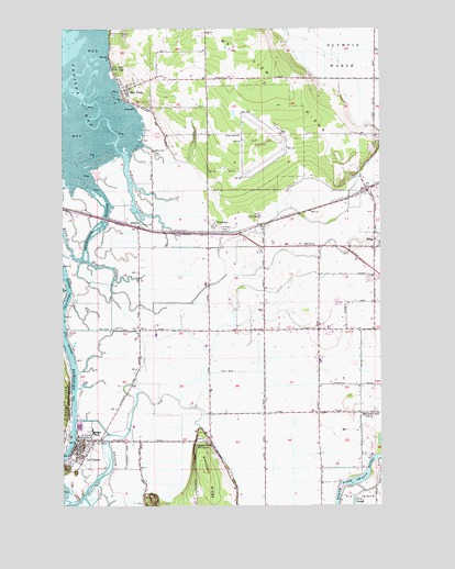
La Conner, WA USGS Topographic Map
Click on map above to begin viewing in our Map Viewer.

This topographic map contains these locations and features:
Feature Name Type Latitude Longitude GNIS ID View Map
AvonPopulated PlaceN48.4423°W122.3785°1515995View Map
Avon United Methodist ChurchChurchN48.4464°W122.3782°2609669View Map
Azusa Farm and GardensLocaleN48.4469°W122.4239°2703841View Map
Bay ViewPopulated PlaceN48.4837°W122.4777°1516198View Map
Bay View CemeteryCemeteryN48.4986°W122.4760°2605495View Map
Bay View Census Designated PlaceCensusN48.4870°W122.4626°2407809View Map
Bay View DivisionCivilN48.4812°W122.4483°1939447View Map
Bay View Elementary SchoolSchoolN48.4881°W122.4176°2518427View Map
Bay View Mobile Home ParkPopulated PlaceN48.4806°W122.4718°2607382View Map
Bay View State ParkParkN48.4887°W122.4802°1516200View Map
Bible Baptist ChurchChurchN48.4365°W122.3807°2609671View Map
Dunbar GardensLocaleN48.4272°W122.3881°2703844View Map
Eagle Mobile Home ParkPopulated PlaceN48.4200°W122.3989°2607384View Map
Floyd Paxton SchoolSchoolN48.4489°W122.3781°2518452View Map
Fohn FarmsLocaleN48.3936°W122.4506°2703824View Map
FredoniaPopulated PlaceN48.4462°W122.4441°1519775View Map
Harmony SchoolLocaleN48.3982°W122.3810°1520558View Map
Higgins SloughGutN48.4379°W122.4838°1520769View Map
Indian SloughStreamN48.4670°W122.4766°1521196View Map
La ConnerPopulated PlaceN48.3887°W122.4963°1534592View Map
La Conner DivisionCivilN48.4073°W122.4391°1939534View Map
La Conner Elementary SchoolSchoolN48.3954°W122.4919°1530705View Map
La Conner Fire DepartmentBuildingN48.3919°W122.4849°2606091View Map
La Conner FlatsFlatN48.3768°W122.4985°1530503View Map
La Conner High SchoolSchoolN48.3950°W122.4898°1530704View Map
La Conner MarinaLocaleN48.3978°W122.4950°2610308View Map
La Conner Middle SchoolSchoolN48.3963°W122.4898°1530706View Map
La Conner Police DepartmentBuildingN48.3886°W122.4974°2721878View Map
La Conner Post OfficePost OfficeN48.3913°W122.4961°2769239View Map
La Conner School District 311 OfficeSchoolN48.3942°W122.4895°2518435View Map
La Conner Sewage Treatment PlantLocaleN48.3912°W122.4852°2610684View Map
LaConner Quilt and Textile MuseumBuildingN48.3900°W122.4962°2610452View Map
LaConner Regional LibraryBuildingN48.3920°W122.4895°2610137View Map
Museum of Northwest ArtBuildingN48.3916°W122.4956°2610460View Map
Olympia MarshSwampN48.4926°W122.3899°1524042View Map
Pleasant RidgeRidgeN48.3823°W122.4438°1524503View Map
Pleasant Ridge CemeteryCemeteryN48.3925°W122.4477°2605502View Map
Pleasant Ridge SchoolLocaleN48.3915°W122.4449°1524504View Map
Port of Skagit County Airport Rescue and Fire DepartmentBuildingN48.4724°W122.4146°2767943View Map
Sacred Heart ChurchChurchN48.3879°W122.4957°2608637View Map
Skagit County Emergency Medical Services Medic OneBuildingN48.4218°W122.4012°2643669View Map
Skagit County Explorer Search and RescueBuildingN48.4791°W122.4171°2643944View Map
Skagit County Fire District 12 Bayview Fire DepartmentBuildingN48.4856°W122.4746°2643658View Map
Skagit County Fire District 2 McLean Road Fire DepartmentBuildingN48.4218°W122.4013°2643653View Map
Skagit County Fire District 2 McLean Road Fire Department Memorial StationBuildingN48.4432°W122.4165°2643654View Map
Skagit County Fire District 6 BayridgeBuildingN48.4718°W122.3958°2606033View Map
Skagit County Sheriff's Office La ConnerBuildingN48.3887°W122.4975°2768887View Map
Skagit Regional AirportAirportN48.4736°W122.4177°1528802View Map
Skagit Valley Bulb FarmLocaleN48.4276°W122.4232°2605537View Map
Sullivan SloughGutN48.3832°W122.4843°1526686View Map
Swinomish ChannelChannelN48.4120°W122.4977°1526870View Map
Swinomish Yacht ClubLocaleN48.3956°W122.4951°2610396View Map
Telegraph SloughGutN48.4479°W122.4863°1526977View Map
Town of La ConnerCivilN48.3926°W122.4946°2412852View Map
Tulip Valley Vineyard and OrchardLocaleN48.4461°W122.3964°2704396View Map
Van Pelt FarmLocaleN48.4289°W122.4358°2703825View Map
WhitneyPopulated PlaceN48.4479°W122.4716°1528105View Map

Note: Coordinates in the location and feature list above are referenced to NAD83 datum.


Copyright (C) 2008-2024 Ryan Niemi / Sunset Dynamics ... All Rights Reserved