TopoQuest Logo
Do you find TopoQuest useful?
Help keep TopoQuest running and adding new maps/features by donating!
Bitcoin:  19c7KJd3qBynnjoSw5npx9KScwjBe4ifkT
Litecoin:  LXs6TkuXGGXo1vDsWCkWVdjQX94eUKd6ui
Home View Maps Find Maps Find Places Resources & Links


Alger, Washington Topographic Map

USGS Map Title: Alger, WA
USGS Map MRC: 48122E3
DRG (GeoTIFF) Download: o48122e3.tif


Neighboring USGS Topographic Map Quads:


  Bellingham South, WA  
48122F4
 

  Lake Whatcom, WA  
48122F3
 

  Acme, WA  
48122F2
 

  Bow, WA  
48122E4
 

  Alger, WA  
48122E3
 

  Sedro-Woolley North, WA  
48122E2
 

  La Conner, WA  
48122D4
 

  Mount Vernon, WA  
48122D3
 

  Sedro-Woolley South, WA  
48122D2


Map MRC Location:

N49°
W123°
N49°
W122°
H8 H7 H6 H5 H4 H3 H2 H1
G8 G7 G6 G5 G4 G3 G2 G1
F8 F7 F6 F5 F4 F3 F2 F1
E8 E7 E6 E5 E4 E3 E2 E1
D8 D7 D6 D5 D4 D3 D2 D1
C8 C7 C6 C5 C4 C3 C2 C1
B8 B7 B6 B5 B4 B3 B2 B1
A8 A7 A6 A5 A4 A3 A2 A1
N48°
W123°
N48°
W122°

Alger, WA USGS 1:24K Topographic Map Preview:
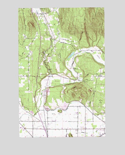
Alger, WA USGS Topographic Map
Click on map above to begin viewing in our Map Viewer.

This topographic map contains these locations and features:
Feature Name Type Latitude Longitude GNIS ID View Map
AlgerPopulated PlaceN48.6198°W122.3413°1510777View Map
Alger Census Designated PlaceCensusN48.6176°W122.3369°2407717View Map
Alger Christian Reformed ChurchChurchN48.6238°W122.3438°2609247View Map
Allen Elementary SchoolSchoolN48.5093°W122.3741°2518476View Map
Anderson MountainSummitN48.6146°W122.2663°1515883View Map
Avalon Golf ClubLocaleN48.5363°W122.3270°2608371View Map
BelfastPopulated PlaceN48.5546°W122.3352°1514881View Map
Belfast Gravel QuarryMineN48.5420°W122.3347°2605619View Map
Belfast SchoolLocaleN48.5546°W122.3352°1503280View Map
BellevilleLocaleN48.5429°W122.3396°1531669View Map
Belleville QuarryMineN48.5243°W122.3530°2605620View Map
Brickyard CreekStreamN48.5082°W122.2929°1503539View Map
Butler CreekStreamN48.5954°W122.3291°1503678View Map
Butler FlatFlatN48.5223°W122.3224°1503680View Map
Butler HillSummitN48.5468°W122.2940°1503681View Map
Butler North QuarryMineN48.5350°W122.3113°2605621View Map
Butler PitMineN48.5271°W122.3345°2605622View Map
Butler QuarryMineN48.5301°W122.3102°2605623View Map
Cook Road Park and RideLocaleN48.5064°W122.3364°2608145View Map
Dans DairyLocaleN48.5011°W122.3094°2703765View Map
De Boer DairyLocaleN48.5231°W122.2928°2703768View Map
Donovan State ParkParkN48.5946°W122.3285°1504510View Map
Dry CreekStreamN48.5818°W122.2768°1504555View Map
Friday CreekStreamN48.5487°W122.3321°1505049View Map
Garden of EdenFlatN48.5340°W122.2613°1505079View Map
Hickson Community HallLocaleN48.5659°W122.2968°1505489View Map
HoogdalPopulated PlaceN48.5582°W122.2593°1511040View Map
Humphrey HillSummitN48.5790°W122.3174°1505664View Map
Jarman PrairieFlatN48.5540°W122.3124°1513928View Map
Parson CreekStreamN48.5826°W122.2857°1507312View Map
Samish HatcheryLocaleN48.5652°W122.3325°2605542View Map
Samish River BridgeBridgeN48.5460°W122.3381°2607973View Map
Samish River QuarryMineN48.5435°W122.3346°2605624View Map
Sedro - Woolley School District 101 OfficeSchoolN48.5042°W122.2512°2518468View Map
Silver CreekStreamN48.6159°W122.3454°1508337View Map
Silver Run GrangeLocaleN48.6234°W122.3438°1508350View Map
Skagit County Fire District 14 Alger Fire DepartmentBuildingN48.5601°W122.3613°2643659View Map
Skagit County Fire District 14 Alger Fire DepartmentBuildingN48.6175°W122.3405°2619521View Map
Skagit County Fire District 8 HicksonBuildingN48.5622°W122.2910°2643665View Map
Skagit QuarryMineN48.5405°W122.3143°2605625View Map
Skagit SpeedwayBuildingN48.5754°W122.3336°2643590View Map
Swede CreekStreamN48.5540°W122.2888°1508870View Map
Thomas CreekStreamN48.5254°W122.3471°1508992View Map
Two Bobs DairyLocaleN48.5556°W122.3367°2703766View Map
Upper Skagit ReservationCivilN48.5685°W122.3534°2419510View Map
Warner PrairieFlatN48.5798°W122.2643°1509292View Map
Wildes CreekStreamN48.5773°W122.3371°1509517View Map
Willard CreekStreamN48.5284°W122.2790°1509606View Map

Note: Coordinates in the location and feature list above are referenced to NAD83 datum.


Copyright (C) 2008-2024 Ryan Niemi / Sunset Dynamics ... All Rights Reserved