TopoQuest Logo
Do you find TopoQuest useful?
Help keep TopoQuest running and adding new maps/features by donating!
Bitcoin:  19c7KJd3qBynnjoSw5npx9KScwjBe4ifkT
Litecoin:  LXs6TkuXGGXo1vDsWCkWVdjQX94eUKd6ui
Home View Maps Find Maps Find Places Resources & Links


Thornwell, Louisiana Topographic Map

USGS Map Title: Thornwell, LA
USGS Map MRC: 30092A7
DRG (GeoTIFF) Download: o30092a7.tif


Neighboring USGS Topographic Map Quads:


  Lacassine, LA  
30092B8
 

  Welsh South, LA  
30092B7
 

  Jennings, LA  
30092B6
 

  Hayes, LA  
30092A8
 

  Thornwell, LA  
30092A7
 

  Lake Arthur, LA  
30092A6


Map MRC Location:

N31°
W93°
N31°
W92°
H8 H7 H6 H5 H4 H3 H2 H1
G8 G7 G6 G5 G4 G3 G2 G1
F8 F7 F6 F5 F4 F3 F2 F1
E8 E7 E6 E5 E4 E3 E2 E1
D8 D7 D6 D5 D4 D3 D2 D1
C8 C7 C6 C5 C4 C3 C2 C1
B8 B7 B6 B5 B4 B3 B2 B1
A8 A7 A6 A5 A4 A3 A2 A1
N30°
W93°
N30°
W92°

Thornwell, LA USGS 1:24K Topographic Map Preview:
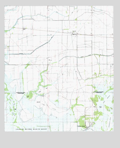
Thornwell, LA USGS Topographic Map
Click on map above to begin viewing in our Map Viewer.

This topographic map contains these locations and features:
Feature Name Type Latitude Longitude GNIS ID View Map
Bayou Chene Volunteer Fire DepartmentBuildingN30.1244°W92.8259°2691832View Map
Biscuit IslandIslandN30.0252°W92.7632°533147View Map
Cane IslandIslandN30.0230°W92.8646°533713View Map
Coto PlotFlatN30.0208°W92.8349°534154View Map
Four RiversGutN30.0249°W92.8665°535063View Map
Goose IslandIslandN30.0241°W92.8229°535285View Map
Goose Island AirportAirportN30.0342°W92.8328°1632747View Map
Great Quelqueshoe PrairieAreaN30.1105°W92.8549°559317View Map
Holton and Winn Drainage CanalCanalN30.0485°W92.8535°535748View Map
KJEF-FM (Jennings)TowerN30.0088°W92.7799°1633063View Map
Louisiana Noname 111 DamDamN30.1202°W92.8651°556983View Map
Lowery Fire StationBuildingN30.0240°W92.7823°2332490View Map
LowryPopulated PlaceN30.0241°W92.7710°543421View Map
Lyon AirportAirportN30.0721°W92.8252°1632968View Map
NiblettPopulated PlaceN30.1030°W92.8538°541151View Map
Niblett CanalCanalN30.1147°W92.8043°537672View Map
Parish Governing Authority District 1CivilN30.0913°W92.7502°1929742View Map
Pine IslandIslandN30.0849°W92.8738°538185View Map
Round IslandIslandN30.0341°W92.8413°538743View Map
South Thornwell Gas FieldOilfieldN30.0541°W92.8099°539515View Map
Southwest Lake Arthur Gas FieldOilfieldN30.0169°W92.8501°550976View Map
Southwestern CanalCanalN30.0910°W92.8238°539531View Map
ThornwellPopulated PlaceN30.0985°W92.7974°539898View Map
Thornwell Drainage CanalCanalN30.0747°W92.7954°539899View Map
Wildcat RidgeRidgeN30.0427°W92.8271°540403View Map

Note: Coordinates in the location and feature list above are referenced to NAD83 datum.


Copyright (C) 2008-2024 Ryan Niemi / Sunset Dynamics ... All Rights Reserved