TopoQuest Logo
Do you find TopoQuest useful?
Help keep TopoQuest running and adding new maps/features by donating!
Bitcoin:  19c7KJd3qBynnjoSw5npx9KScwjBe4ifkT
Litecoin:  LXs6TkuXGGXo1vDsWCkWVdjQX94eUKd6ui
Home View Maps Find Maps Find Places Resources & Links


Lafayette, Oklahoma Topographic Map

USGS Map Title: Lafayette, OK
USGS Map MRC: 35095B1
DRG (GeoTIFF) Download: o35095b1.tif


Neighboring USGS Topographic Map Quads:


  Stigler West, OK  
35095C2
 

  Stigler East, OK  
35095C1
 

  Keota, OK  
35094C8
 

  Sans Bois, OK  
35095B2
 

  Lafayette, OK  
35095B1
 

  McCurtain, OK  
35094B8
 

  Kinta, OK  
35095A2
 

  Lequire, OK  
35095A1
 

  McCurtain SW, OK  
35094A8


Map MRC Location:

N36°
W96°
N36°
W95°
H8 H7 H6 H5 H4 H3 H2 H1
G8 G7 G6 G5 G4 G3 G2 G1
F8 F7 F6 F5 F4 F3 F2 F1
E8 E7 E6 E5 E4 E3 E2 E1
D8 D7 D6 D5 D4 D3 D2 D1
C8 C7 C6 C5 C4 C3 C2 C1
B8 B7 B6 B5 B4 B3 B2 B1
A8 A7 A6 A5 A4 A3 A2 A1
N35°
W96°
N35°
W95°

Lafayette, OK USGS 1:24K Topographic Map Preview:
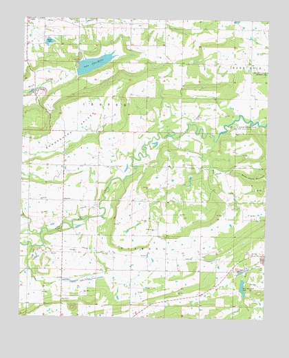
Lafayette, OK USGS Topographic Map
Click on map above to begin viewing in our Map Viewer.

This topographic map contains these locations and features:
Feature Name Type Latitude Longitude GNIS ID View Map
Choctaw MineMineN35.1893°W95.0402°1091327View Map
County District 5CivilN35.2347°W95.0764°2418892View Map
Haskell CountyCivilN35.2248°W95.1166°1101818View Map
John Wells ParkParkN35.2315°W95.0977°1094239View Map
Kiamichi Technology Center StiglerSchoolN35.2481°W95.1082°1790474View Map
LafayettePopulated PlaceN35.1740°W95.1036°1100559View Map
Lafayette ChurchChurchN35.1743°W95.1152°1094454View Map
Lake John WellsReservoirN35.2310°W95.0895°1094472View Map
Lake John Wells DamDamN35.2268°W95.0969°1751294View Map
Lone Star Steel LakeReservoirN35.1383°W95.0114°1094932View Map
McCurtain DivisionCivilN35.1660°W95.0550°1937763View Map
McCurtain Indian Reservation (historical)CivilN35.1576°W95.0083°1763631View Map
Mule CreekStreamN35.1712°W95.0002°1095698View Map
Old Panther CemeteryCemeteryN35.1334°W95.0033°1096247View Map
Old Panther CemeteryCemeteryN35.1334°W95.0035°1934792View Map
Robert Mitchell LakeReservoirN35.1834°W95.0386°1759024View Map
Robert Mitchell Lake DamDamN35.1834°W95.0386°1759023View Map
Rose Hill ChurchChurchN35.1323°W95.1033°1097439View Map
Shropshire ValleyValleyN35.2023°W95.0869°1098030View Map
Siloam Spring ChurchChurchN35.1618°W95.0566°1098040View Map
Siloam Springs CemeteryCemeteryN35.1630°W95.0555°2709104View Map
Southside Volunteer Fire DepartmentBuildingN35.2435°W95.1075°2657061View Map
Stigler DamDamN35.2418°W95.1136°1759025View Map
Stigler LakeReservoirN35.2402°W95.1122°1098538View Map
Township of CenterCivilN35.2140°W95.0863°1824655View Map

Note: Coordinates in the location and feature list above are referenced to NAD83 datum.


Copyright (C) 2008-2025 Ryan Niemi / Sunset Dynamics ... All Rights Reserved