TopoQuest Logo
Do you find TopoQuest useful?
Help keep TopoQuest running and adding new maps/features by donating!
Bitcoin:  19c7KJd3qBynnjoSw5npx9KScwjBe4ifkT
Litecoin:  LXs6TkuXGGXo1vDsWCkWVdjQX94eUKd6ui
Home View Maps Find Maps Find Places Resources & Links


Keota, Oklahoma Topographic Map

USGS Map Title: Keota, OK
USGS Map MRC: 35094C8
DRG (GeoTIFF) Download: o35094c8.tif


Neighboring USGS Topographic Map Quads:


  Stigler NE, OK  
35095D1
 

  Vian, OK  
35094D8
 

  Sallisaw, OK  
35094D7
 

  Stigler East, OK  
35095C1
 

  Keota, OK  
35094C8
 

  Robert S Kerr Dam, OK  
35094C7
 

  Lafayette, OK  
35095B1
 

  McCurtain, OK  
35094B8
 

  Bokoshe, OK  
35094B7


Map MRC Location:

N36°
W95°
N36°
W94°
H8 H7 H6 H5 H4 H3 H2 H1
G8 G7 G6 G5 G4 G3 G2 G1
F8 F7 F6 F5 F4 F3 F2 F1
E8 E7 E6 E5 E4 E3 E2 E1
D8 D7 D6 D5 D4 D3 D2 D1
C8 C7 C6 C5 C4 C3 C2 C1
B8 B7 B6 B5 B4 B3 B2 B1
A8 A7 A6 A5 A4 A3 A2 A1
N35°
W95°
N35°
W94°

Keota, OK USGS 1:24K Topographic Map Preview:
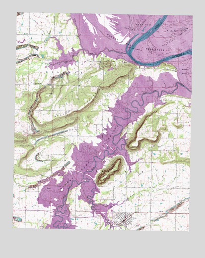
Keota, OK USGS Topographic Map
Click on map above to begin viewing in our Map Viewer.

This topographic map contains these locations and features:
Feature Name Type Latitude Longitude GNIS ID View Map
Bellow MountainSummitN35.3154°W94.9875°1089990View Map
Bellow Mountain ChurchChurchN35.3284°W94.9738°1089991View Map
Elm BranchStreamN35.2648°W94.9427°1092551View Map
Foliart MountainSummitN35.3004°W94.9141°1092920View Map
Hancock MountainSummitN35.2859°W94.9288°1093506View Map
KeotaPopulated PlaceN35.2557°W94.9216°1094338View Map
Keota CemeteryCemeteryN35.2704°W94.9213°1094339View Map
Keota DivisionCivilN35.2905°W94.9010°1937747View Map
Keota Elementary SchoolSchoolN35.2592°W94.9206°1803538View Map
Keota Fire DistrictBuildingN35.2556°W94.9219°2656882View Map
Keota High SchoolSchoolN35.2577°W94.9209°1790380View Map
Keota Police DepartmentBuildingN35.2558°W94.9219°2757590View Map
Little Sans Bois CemeteryCemeteryN35.3340°W94.9872°1094841View Map
Little Sans Bois CreekStreamN35.3526°W94.9219°1094842View Map
Lone Elm ChurchChurchN35.2612°W94.8966°1094899View Map
Mulehead BottomBendN35.3623°W94.8866°1095700View Map
New Hope ChurchChurchN35.2504°W94.9788°1095817View Map
Oknoname 061002 ReservoirReservoirN35.3451°W94.9286°1751219View Map
Oknoname 361002 DamDamN35.3451°W94.9286°1751218View Map
Otter CreekStreamN35.2790°W94.9469°1096342View Map
Red HillSummitN35.3459°W94.9341°1097096View Map
Red HillPopulated PlaceN35.3473°W94.9405°1100778View Map
Robert S Kerr ReservoirReservoirN35.3638°W94.9090°1097254View Map
Rock Ford ChurchChurchN35.3082°W94.9377°1097347View Map
Shoat CreekStreamN35.2782°W94.9577°1098008View Map
Simon Isaac CemeteryCemeteryN35.2803°W94.9767°2709105View Map
Town of KeotaCivilN35.2569°W94.9225°2412827View Map
Township of Sans BoisCivilN35.2973°W94.9266°1824656View Map

Note: Coordinates in the location and feature list above are referenced to NAD83 datum.


Copyright (C) 2008-2025 Ryan Niemi / Sunset Dynamics ... All Rights Reserved