TopoQuest Logo
Do you find TopoQuest useful?
Help keep TopoQuest running and adding new maps/features by donating!
Bitcoin:  19c7KJd3qBynnjoSw5npx9KScwjBe4ifkT
Litecoin:  LXs6TkuXGGXo1vDsWCkWVdjQX94eUKd6ui
Home View Maps Find Maps Find Places Resources & Links


Stigler East, Oklahoma Topographic Map

USGS Map Title: Stigler East, OK
USGS Map MRC: 35095C1
DRG (GeoTIFF) Download: o35095c1.tif


Neighboring USGS Topographic Map Quads:


  Holt Mountain, OK  
35095D2
 

  Stigler NE, OK  
35095D1
 

  Vian, OK  
35094D8
 

  Stigler West, OK  
35095C2
 

  Stigler East, OK  
35095C1
 

  Keota, OK  
35094C8
 

  Sans Bois, OK  
35095B2
 

  Lafayette, OK  
35095B1
 

  McCurtain, OK  
35094B8


Map MRC Location:

N36°
W96°
N36°
W95°
H8 H7 H6 H5 H4 H3 H2 H1
G8 G7 G6 G5 G4 G3 G2 G1
F8 F7 F6 F5 F4 F3 F2 F1
E8 E7 E6 E5 E4 E3 E2 E1
D8 D7 D6 D5 D4 D3 D2 D1
C8 C7 C6 C5 C4 C3 C2 C1
B8 B7 B6 B5 B4 B3 B2 B1
A8 A7 A6 A5 A4 A3 A2 A1
N35°
W96°
N35°
W95°

Stigler East, OK USGS 1:24K Topographic Map Preview:
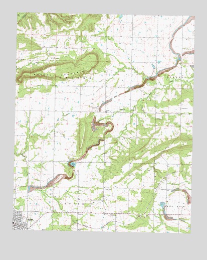
Stigler East, OK USGS Topographic Map
Click on map above to begin viewing in our Map Viewer.

This topographic map contains these locations and features:
Feature Name Type Latitude Longitude GNIS ID View Map
Antioch CemeteryCemeteryN35.2506°W95.0783°1089649View Map
Antioch ChurchChurchN35.2601°W95.0791°1089658View Map
Cedarburg CreekStreamN35.3234°W95.0375°1091136View Map
City of StiglerCivilN35.2566°W95.1185°2411981View Map
Club LakeLakeN35.2885°W95.0836°1091489View Map
Crossroads ChurchChurchN35.2604°W95.0619°1091847View Map
Cumberland ChurchChurchN35.3218°W95.0091°1091885View Map
First Christian ChurchChurchN35.2593°W95.1194°1810036View Map
GarlandPopulated PlaceN35.3190°W95.0516°1100442View Map
Garland CemeteryCemeteryN35.3217°W95.0672°2709101View Map
Garland ChapelChurchN35.3209°W95.0669°1093124View Map
Garland SchoolSchoolN35.3190°W95.0622°1093127View Map
Haskell County Sheriff's OfficeBuildingN35.2533°W95.1242°2757794View Map
Kanima SchoolSchoolN35.2748°W95.0172°1094284View Map
Morgan MountainSummitN35.3404°W95.1061°1095511View Map
Rucker SchoolSchoolN35.2743°W95.0569°1097518View Map
StiglerPopulated PlaceN35.2537°W95.1230°1098537View Map
Stigler DivisionCivilN35.3407°W95.0653°1937878View Map
Stigler Elementary SchoolSchoolN35.2551°W95.1201°1819359View Map
Stigler Regional AirportAirportN35.2885°W95.0955°1102675View Map
Township of TalokaCivilN35.3390°W95.0863°1824652View Map
United Methodist ChurchChurchN35.2587°W95.1244°1810037View Map

Note: Coordinates in the location and feature list above are referenced to NAD83 datum.


Copyright (C) 2008-2024 Ryan Niemi / Sunset Dynamics ... All Rights Reserved