TopoQuest Logo
Do you find TopoQuest useful?
Help keep TopoQuest running and adding new maps/features by donating!
Bitcoin:  19c7KJd3qBynnjoSw5npx9KScwjBe4ifkT
Litecoin:  LXs6TkuXGGXo1vDsWCkWVdjQX94eUKd6ui
Home View Maps Find Maps Find Places Resources & Links


Rio Hondo, Texas Topographic Map

USGS Map Title: Rio Hondo, TX
USGS Map MRC: 26097B5
DRG (GeoTIFF) Download: o26097b5.tif


Neighboring USGS Topographic Map Quads:


  Willamar SW, TX  
26097C6
 

  Paso Real, TX  
26097C5
 

  La Leona, TX  
26097C4
 

  Harlingen, TX  
26097B6
 

  Rio Hondo, TX  
26097B5
 

  Laguna Atascosa, TX  
26097B4
 

  La Paloma, TX  
26097A6
 

  Olmito, TX  
26097A5
 

  Los Fresnos, TX  
26097A4


Map MRC Location:

N27°
W98°
N27°
W97°
H8 H7 H6 H5 H4 H3 H2 H1
G8 G7 G6 G5 G4 G3 G2 G1
F8 F7 F6 F5 F4 F3 F2 F1
E8 E7 E6 E5 E4 E3 E2 E1
D8 D7 D6 D5 D4 D3 D2 D1
C8 C7 C6 C5 C4 C3 C2 C1
B8 B7 B6 B5 B4 B3 B2 B1
A8 A7 A6 A5 A4 A3 A2 A1
N26°
W98°
N26°
W97°

Rio Hondo, TX USGS 1:24K Topographic Map Preview:
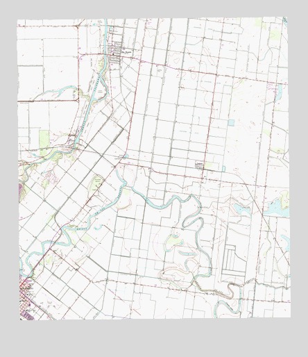
Rio Hondo, TX USGS Topographic Map
Click on map above to begin viewing in our Map Viewer.

This topographic map contains these locations and features:
Feature Name Type Latitude Longitude GNIS ID View Map
Abbott DamDamN26.2220°W97.5986°1862224View Map
Abbott ReservoirReservoirN26.2211°W97.6046°1862225View Map
ArroyoLocaleN26.1967°W97.6014°1329704View Map
Arroyo Colorado Estates Census Designated PlaceCensusN26.1864°W97.6114°2407767View Map
Arroyo Colorado Estates ColoniaPopulated PlaceN26.1892°W97.6083°2010316View Map
Arroyo Gardens Census Designated PlaceCensusN26.2052°W97.5021°2584606View Map
Arroyo Gardens Number 1 ColoniaPopulated PlaceN26.1954°W97.5033°2010317View Map
Bullis Addition ColoniaPopulated PlaceN26.2215°W97.5822°2010329View Map
Cameron County Constable's Office Precinct 4BuildingN26.2351°W97.5791°2739506View Map
Cameron County Juvenile Justice Alternative Education Program SchoolSchoolN26.2347°W97.5802°2434384View Map
Cash Elementary SchoolSchoolN26.1297°W97.6221°2003763View Map
City of Rio HondoCivilN26.2346°W97.5816°2410953View Map
Cuates Dam Number 1 and 2DamN26.1370°W97.5236°1862228View Map
Cuates LakeLakeN26.1295°W97.5287°1373302View Map
Cuates LakeReservoirN26.1354°W97.5235°1862229View Map
Doctor Cash SchoolSchoolN26.1292°W97.6219°1334432View Map
Dolly Vinsant Memorial HospitalHospitalN26.1361°W97.6218°1334468View Map
Downs SchoolSchoolN26.1392°W97.6211°1334589View Map
Ed Downs Elementary SchoolSchoolN26.1396°W97.6206°2003773View Map
Glenwood Acres ColoniaPopulated PlaceN26.1342°W97.5622°2010257View Map
Jones Addition ColoniaPopulated PlaceN26.2315°W97.5803°2010270View Map
KMBH-FM (Harlingen)TowerN26.1798°W97.5019°1385873View Map
Kornegay Private AirportAirportN26.1508°W97.5932°1387486View Map
La Coma ColoniaPopulated PlaceN26.1323°W97.5008°2010274View Map
LantanaPopulated PlaceN26.1931°W97.5789°1378561View Map
Las Palomas Wildlife Management Area - Carricitos UnitParkN26.1762°W97.5780°2029015View Map
Las YescasPopulated PlaceN26.2229°W97.5058°1339690View Map
Las Yescas Elementary SchoolSchoolN26.2188°W97.5059°2434363View Map
Lopez ColoniaPopulated PlaceN26.2315°W97.5814°2010288View Map
LozanoPopulated PlaceN26.1892°W97.5411°1340707View Map
Lozano Census Designated PlaceCensusN26.1896°W97.5437°2408148View Map
Lozano Post OfficePost OfficeN26.1861°W97.5406°2732349View Map
Miller Jordan Middle SchoolSchoolN26.1319°W97.6210°2003705View Map
Monte Meta CemeteryCemeteryN26.1829°W97.5886°1341820View Map
Montgomeery DamDamN26.2237°W97.5853°1862226View Map
Montgomery ReservoirReservoirN26.2176°W97.5850°1862227View Map
Pentecostal Holiness ChurchChurchN26.1326°W97.6208°2016733View Map
Port HarlingenPopulated PlaceN26.1992°W97.6014°1378900View Map
Rancho Grande ColoniaPopulated PlaceN26.1454°W97.5992°2010200View Map
Rio HondoPopulated PlaceN26.2354°W97.5819°1345245View Map
Rio Hondo City HallBuildingN26.2364°W97.5839°2753591View Map
Rio Hondo Elementary SchoolSchoolN26.2419°W97.5804°2434343View Map
Rio Hondo Fire DepartmentBuildingN26.2359°W97.5837°2334331View Map
Rio Hondo High SchoolSchoolN26.2308°W97.5678°2434429View Map
Rio Hondo Intermediate SchoolSchoolN26.2402°W97.5809°2003746View Map
Rio Hondo Junior High SchoolSchoolN26.2362°W97.5814°2434382View Map
Rio Hondo Police DepartmentBuildingN26.2364°W97.5839°2335067View Map
Rio Hondo Post OfficePost OfficeN26.2349°W97.5770°2731742View Map
San Benito Municipal Airport (historical)AirportN26.1340°W97.6128°1387485View Map
San Vicente Estates ColoniaPopulated PlaceN26.2265°W97.5253°2010210View Map
Stokey ParkParkN26.1254°W97.6158°2030097View Map
Sweeney LakeReservoirN26.1693°W97.5037°1348126View Map
Tatum Addition ColoniaPopulated PlaceN26.2292°W97.5822°2010226View Map
Texas Air Museum Airport (historical)AirportN26.2305°W97.5611°1387399View Map
Villa del SolPopulated PlaceN26.1915°W97.5742°1852777View Map
Villa del Sol Census Designated PlaceCensusN26.1915°W97.5782°2409513View Map
Villa del Sol ColoniaPopulated PlaceN26.1915°W97.5742°2010237View Map
Wardner LeveeDamN26.1670°W97.5219°1862230View Map
Wardner ReservoirReservoirN26.1670°W97.5219°1862231View Map
West Addition ColoniaPopulated PlaceN26.2304°W97.5822°2010240View Map

Note: Coordinates in the location and feature list above are referenced to NAD83 datum.


Copyright (C) 2008-2025 Ryan Niemi / Sunset Dynamics ... All Rights Reserved