TopoQuest Logo
Do you find TopoQuest useful?
Help keep TopoQuest running and adding new maps/features by donating!
Bitcoin:  19c7KJd3qBynnjoSw5npx9KScwjBe4ifkT
Litecoin:  LXs6TkuXGGXo1vDsWCkWVdjQX94eUKd6ui
Home View Maps Find Maps Find Places Resources & Links


Lake Arrowhead, California Topographic Map

USGS Map Title: Lake Arrowhead, CA
USGS Map MRC: 34117C2
DRG (GeoTIFF) Download: o34117c2.tif


Neighboring USGS Topographic Map Quads:


  Hesperia, CA  
34117D3
 

  Apple Valley South, CA  
34117D2
 

  Fifteenmile Valley, CA  
34117D1
 

  Silverwood Lake, CA  
34117C3
 

  Lake Arrowhead, CA  
34117C2
 

  Butler Peak, CA  
34117C1
 

  San Bernardino North, CA  
34117B3
 

  Harrison Mountain, CA  
34117B2
 

  Keller Peak, CA  
34117B1


Map MRC Location:

N35°
W118°
N35°
W117°
H8 H7 H6 H5 H4 H3 H2 H1
G8 G7 G6 G5 G4 G3 G2 G1
F8 F7 F6 F5 F4 F3 F2 F1
E8 E7 E6 E5 E4 E3 E2 E1
D8 D7 D6 D5 D4 D3 D2 D1
C8 C7 C6 C5 C4 C3 C2 C1
B8 B7 B6 B5 B4 B3 B2 B1
A8 A7 A6 A5 A4 A3 A2 A1
N34°
W118°
N34°
W117°

Lake Arrowhead, CA USGS 1:24K Topographic Map Preview:
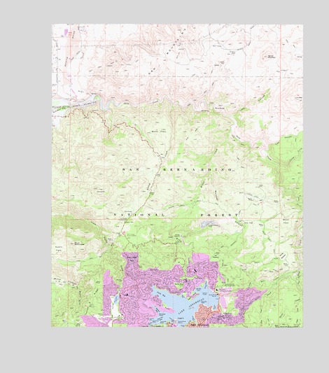
Lake Arrowhead, CA USGS Topographic Map
Click on map above to begin viewing in our Map Viewer.

This topographic map contains these locations and features:
Feature Name Type Latitude Longitude GNIS ID View Map
Arrowhead Equestrian EstatesPopulated PlaceN34.3578°W117.2498°1841815View Map
Ash MeadowsFlatN34.2783°W117.1692°269600View Map
Bacon FlatsFlatN34.2936°W117.1339°269622View Map
Blue Jay BayBayN34.2536°W117.1962°269928View Map
Bowen RanchLocaleN34.3631°W117.1620°269993View Map
Burnt FlatsFlatN34.3308°W117.1973°270096View Map
Burnt Mill CreekStreamN34.2511°W117.1939°270097View Map
Calvary Chapel Christian SchoolSchoolN34.2514°W117.2358°1841823View Map
Cedar CreekStreamN34.2606°W117.1287°270364View Map
Cedar GlenPopulated PlaceN34.2539°W117.1648°1660452View Map
Cedar Glen Post OfficePost OfficeN34.2549°W117.1709°1841824View Map
Cedar Glen Post Office (historical)Post OfficeN34.2539°W117.1648°2026850View Map
Coxey CreekStreamN34.3164°W117.1378°270657View Map
Deep CreekStreamN34.3414°W117.2375°270792View Map
Deer Lodge ParkParkN34.2769°W117.2109°270806View Map
Eagle PointCapeN34.2628°W117.1803°270970View Map
Emerald BayBayN34.2589°W117.1692°271060View Map
Fern CreekStreamN34.2620°W117.1462°271120View Map
Grandview Elementary SchoolSchoolN34.2523°W117.2369°1841831View Map
Grass ValleyBasinN34.2556°W117.2189°271409View Map
Grass Valley 805-002 DamDamN34.2617°W117.2181°1664071View Map
Grass Valley LakeReservoirN34.2614°W117.2187°271410View Map
Holcomb CreekStreamN34.2875°W117.1264°271602View Map
Hooks CreekStreamN34.2695°W117.1387°271616View Map
Hot SpringSpringN34.3392°W117.1768°271664View Map
Kinley CreekStreamN34.3419°W117.1909°271906View Map
Lake ArrowheadReservoirN34.2588°W117.1855°269582View Map
Lake Arrowhead 805 DamDamN34.2617°W117.1675°1664070View Map
Lake Arrowhead AirportAirportN34.3037°W117.1501°2376289View Map
Lake Arrowhead Census Designated PlaceCensusN34.2531°W117.1945°2408532View Map
Lake Arrowhead Country ClubLocaleN34.2547°W117.2173°1841840View Map
Lake Arrowhead Elementary SchoolSchoolN34.2736°W117.1792°271961View Map
Lake Arrowhead Post OfficePost OfficeN34.2501°W117.1901°1841944View Map
Lake Arrowhead Scout CampsLocaleN34.2511°W117.1278°271962View Map
Lake Arrowhead Village Shopping CenterLocaleN34.2506°W117.1895°1841841View Map
Lion CanyonValleyN34.3242°W117.1437°272053View Map
Little Bear CreekStreamN34.2736°W117.1281°272068View Map
Lone Pine IslandIslandN34.2522°W117.1970°272172View Map
Long PointCapeN34.2581°W117.1950°272192View Map
Luna CanyonValleyN34.3367°W117.1617°272281View Map
Luna MountainSummitN34.3439°W117.1278°272282View Map
Maloney CanyonValleyN34.3136°W117.1720°272322View Map
Mary P Henck Intermediate SchoolSchoolN34.2636°W117.2128°271547View Map
Meadow BayBayN34.2572°W117.1981°272405View Map
Mojave DamDamN34.3433°W117.2342°1664515View Map
Mojave River Camp (historical)LocaleN34.3433°W117.2312°1701128View Map
Mojave River Forks ReservoirReservoirN34.3456°W117.2312°272519View Map
Mount Marie LouiseSummitN34.2842°W117.2395°272350View Map
Mountains Community HospitalHospitalN34.2655°W117.1687°1661076View Map
Mountains Community Hospital HeliportAirportN34.2653°W117.1689°1653586View Map
Mountaintop AcademySchoolN34.2606°W117.1534°2455730View Map
New Lake Arrowhead 1803-002 DamDamN34.2617°W117.1659°1664436View Map
North BayBayN34.2636°W117.1959°272664View Map
North ShorePopulated PlaceN34.2681°W117.1842°1661122View Map
North Shore CampgroundLocaleN34.2672°W117.1642°272715View Map
North Shore MarinaLocaleN34.2631°W117.1684°272716View Map
North Shore Ranger StationLocaleN34.2661°W117.1642°1701129View Map
Orchard BayBayN34.2533°W117.1806°272807View Map
Orchard CreekStreamN34.2520°W117.1787°272808View Map
Palisades PointCapeN34.2595°W117.1767°272844View Map
Papoose LakeReservoirN34.2603°W117.1656°1841852View Map
Paradise BayBayN34.2514°W117.2020°272865View Map
Rainbow BayBayN34.2531°W117.2009°273172View Map
Rainbow PointCapeN34.2550°W117.1973°273175View Map
Rock Camp Guard StationLocaleN34.2881°W117.2128°273306View Map
Round MountainSummitN34.3617°W117.1437°273366View Map
Rouse MeadowFlatN34.2800°W117.1359°273377View Map
Saddle FlatsFlatN34.2822°W117.2473°273389View Map
San Bernardino County Fire Department Station 92 - Lake ArrowheadBuildingN34.2678°W117.1690°2665088View Map
San Bernardino County Fire Department Station 93 - Lake ArrowheadBuildingN34.2534°W117.1744°2665081View Map
San Bernardino County Fire Department Station 94 - Lake ArrowheadBuildingN34.2614°W117.2042°2665086View Map
Shake CreekStreamN34.2628°W117.1259°273649View Map
Shelter CoveBayN34.2656°W117.1770°273670View Map
South Shore MarinaLocaleN34.2517°W117.1878°273852View Map
Squints RanchLocaleN34.3022°W117.1509°273882View Map
Stove FlatsFlatN34.2928°W117.1531°273926View Map
Tavern BayBayN34.2625°W117.1853°274040View Map
The PinnaclesSummitN34.3067°W117.2281°274097View Map
Toll Road CampgroundLocaleN34.2944°W117.2134°274153View Map
Totem Pole PointCapeN34.2525°W117.2006°274169View Map
Tunnel Two RidgeRidgeN34.2592°W117.2314°274223View Map
University of California Los Angeles Conference CenterBuildingN34.2650°W117.1862°1841864View Map
Village BayBayN34.2506°W117.1850°274341View Map
Village PointCapeN34.2531°W117.1884°274343View Map
Warm SpringSpringN34.3409°W117.1698°274381View Map
West Fork Mojave RiverStreamN34.3414°W117.2373°274439View Map
Willow CreekStreamN34.3314°W117.1614°274513View Map
Willow Creek Jeep TrailTrailN34.3008°W117.1820°274518View Map
Winter Harbor CoveBayN34.2675°W117.1748°274559View Map
Yacht Club BayBayN34.2528°W117.1903°274583View Map

Note: Coordinates in the location and feature list above are referenced to NAD83 datum.


Copyright (C) 2008-2024 Ryan Niemi / Sunset Dynamics ... All Rights Reserved