TopoQuest Logo
Do you find TopoQuest useful?
Help keep TopoQuest running and adding new maps/features by donating!
Bitcoin:  19c7KJd3qBynnjoSw5npx9KScwjBe4ifkT
Litecoin:  LXs6TkuXGGXo1vDsWCkWVdjQX94eUKd6ui
Home View Maps Find Maps Find Places Resources & Links


Silverwood Lake, California Topographic Map

USGS Map Title: Silverwood Lake, CA
USGS Map MRC: 34117C3
DRG (GeoTIFF) Download: o34117c3.tif


Neighboring USGS Topographic Map Quads:


  Baldy Mesa, CA  
34117D4
 

  Hesperia, CA  
34117D3
 

  Apple Valley South, CA  
34117D2
 

  Cajon, CA  
34117C4
 

  Silverwood Lake, CA  
34117C3
 

  Lake Arrowhead, CA  
34117C2
 

  Devore, CA  
34117B4
 

  San Bernardino North, CA  
34117B3
 

  Harrison Mountain, CA  
34117B2


Map MRC Location:

N35°
W118°
N35°
W117°
H8 H7 H6 H5 H4 H3 H2 H1
G8 G7 G6 G5 G4 G3 G2 G1
F8 F7 F6 F5 F4 F3 F2 F1
E8 E7 E6 E5 E4 E3 E2 E1
D8 D7 D6 D5 D4 D3 D2 D1
C8 C7 C6 C5 C4 C3 C2 C1
B8 B7 B6 B5 B4 B3 B2 B1
A8 A7 A6 A5 A4 A3 A2 A1
N34°
W118°
N34°
W117°

Silverwood Lake, CA USGS 1:24K Topographic Map Preview:
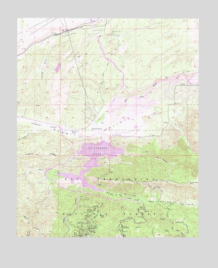
Silverwood Lake, CA USGS Topographic Map
Click on map above to begin viewing in our Map Viewer.

This topographic map contains these locations and features:
Feature Name Type Latitude Longitude GNIS ID View Map
Black Oak Picnic AreaLocaleN34.2800°W117.3334°1841821View Map
Breezy PointCapeN34.2620°W117.3139°239669View Map
Burnt Mill CanyonValleyN34.2747°W117.3128°239869View Map
Burnt Mill CreekStreamN34.2753°W117.3128°1841822View Map
Camp SeeleyLocaleN34.2556°W117.3039°240109View Map
Cedar Spring DamDamN34.3050°W117.3141°274983View Map
Cedar Springs (historical)Populated PlaceN34.2833°W117.3342°1702007View Map
Cedarpines ParkPopulated PlaceN34.2500°W117.3259°1660455View Map
Chamise Picnic AreaLocaleN34.2967°W117.3323°1841825View Map
Cleghorn Day Use AreaLocaleN34.2875°W117.3487°1841826View Map
Cottonwood Forest StationLocaleN34.2822°W117.3523°275056View Map
Dart CreekStreamN34.2558°W117.2678°241268View Map
East Fork West Fork Mojave RiverStreamN34.2764°W117.3172°254055View Map
Grass Valley CreekStreamN34.3383°W117.2700°242954View Map
Horsethief CanyonValleyN34.3231°W117.3087°243673View Map
Houston CreekStreamN34.2708°W117.2800°243698View Map
Jamajab PointCapeN34.2803°W117.3250°1841836View Map
Lake Arrowhead DivisionCivilN34.2603°W117.2822°1935015View Map
Las Flores RanchLocaleN34.3111°W117.3231°244611View Map
Las Flores SchoolSchoolN34.3103°W117.3370°244614View Map
Little Horsethief CanyonValleyN34.3122°W117.3564°244917View Map
Live Oak Landing Picnic AreaLocaleN34.2967°W117.3053°1841847View Map
LugoPopulated PlaceN34.3672°W117.3423°252928View Map
Lugo Substation HeliportAirportN34.3686°W117.3709°1653525View Map
Lynx PointSummitN34.2747°W117.3089°1841848View Map
Mesa CampgroundLocaleN34.2839°W117.3489°1841849View Map
Miller CanyonValleyN34.2842°W117.3306°245923View Map
Miller Canyon TrailTrailN34.2689°W117.2589°245925View Map
Pillars of GodBasinN34.2650°W117.3245°247466View Map
Pilot RockSummitN34.2811°W117.2570°247472View Map
Pilot Rock Conservation CampLocaleN34.2717°W117.2817°1841855View Map
Pilot Rock Truck TrailTrailN34.2822°W117.2739°247473View Map
Rio Baranca Valle CampgroundLocaleN34.2872°W117.3606°1841856View Map
San Bernardino County Regional Park CampgroundLocaleN34.3311°W117.2653°274982View Map
Sawpit CanyonValleyN34.2803°W117.3367°249182View Map
Seeley CreekStreamN34.2739°W117.3028°249249View Map
Seeley FlatFlatN34.2525°W117.3042°249251View Map
Serrano Beach Picnic AreaLocaleN34.2792°W117.3217°1841858View Map
Silverwood LakeReservoirN34.2937°W117.3235°249498View Map
Silverwood Lake State Recreation AreaParkN34.2911°W117.3284°1701130View Map
Silverwood Lake State Recreation Area Visitors CenterBuildingN34.2844°W117.3520°1841861View Map
Summit ValleyValleyN34.3381°W117.2700°250081View Map
Sycamore Landing Picnic AreaLocaleN34.2925°W117.3145°1841863View Map
Telephone CanyonValleyN34.3619°W117.3514°250310View Map

Note: Coordinates in the location and feature list above are referenced to NAD83 datum.


Copyright (C) 2008-2024 Ryan Niemi / Sunset Dynamics ... All Rights Reserved