TopoQuest Logo
Do you find TopoQuest useful?
Help keep TopoQuest running and adding new maps/features by donating!
Bitcoin:  19c7KJd3qBynnjoSw5npx9KScwjBe4ifkT
Litecoin:  LXs6TkuXGGXo1vDsWCkWVdjQX94eUKd6ui
Home View Maps Find Maps Find Places Resources & Links


Apple Valley South, California Topographic Map

USGS Map Title: Apple Valley South, CA
USGS Map MRC: 34117D2
DRG (GeoTIFF) Download: o34117d2.tif


Neighboring USGS Topographic Map Quads:


  Victorville, CA  
34117E3
 

  Apple Valley North, CA  
34117E2
 

  Fairview Valley, CA  
34117E1
 

  Hesperia, CA  
34117D3
 

  Apple Valley South, CA  
34117D2
 

  Fifteenmile Valley, CA  
34117D1
 

  Silverwood Lake, CA  
34117C3
 

  Lake Arrowhead, CA  
34117C2
 

  Butler Peak, CA  
34117C1


Map MRC Location:

N35°
W118°
N35°
W117°
H8 H7 H6 H5 H4 H3 H2 H1
G8 G7 G6 G5 G4 G3 G2 G1
F8 F7 F6 F5 F4 F3 F2 F1
E8 E7 E6 E5 E4 E3 E2 E1
D8 D7 D6 D5 D4 D3 D2 D1
C8 C7 C6 C5 C4 C3 C2 C1
B8 B7 B6 B5 B4 B3 B2 B1
A8 A7 A6 A5 A4 A3 A2 A1
N34°
W118°
N34°
W117°

Apple Valley South, CA USGS 1:24K Topographic Map Preview:
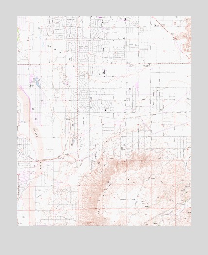
Apple Valley South, CA USGS Topographic Map
Click on map above to begin viewing in our Map Viewer.

This topographic map contains these locations and features:
Feature Name Type Latitude Longitude GNIS ID View Map
Antelope ValleyValleyN34.4083°W117.2373°269550View Map
Apple Valley Adult SchoolSchoolN34.4883°W117.1634°1841706View Map
Apple Valley Christian SchoolSchoolN34.4867°W117.1750°1841707View Map
Apple Valley Community CenterBuildingN34.4961°W117.1898°1701121View Map
Apple Valley Fire Protection District Station 334BuildingN34.4722°W117.2074°2665004View Map
Apple Valley Fire Protection District Station 335BuildingN34.4429°W117.1859°2664999View Map
Apple Valley Fire Protection District Station 336BuildingN34.4999°W117.2439°2665360View Map
Apple Valley Fire Protection District Station 337BuildingN34.4598°W117.2420°2665125View Map
Apple Valley High SchoolSchoolN34.4673°W117.1893°1841708View Map
Apple Valley HighlandsPopulated PlaceN34.3911°W117.2175°1841709View Map
Apple Valley Post OfficePost OfficeN34.4996°W117.1809°1841635View Map
Apple Valley Senior Citizens ClubBuildingN34.4914°W117.1731°1841711View Map
Bass Sports CenterParkN34.4697°W117.1884°1841712View Map
Carmel Elementary SchoolSchoolN34.4216°W117.2411°1841713View Map
Circle M RanchLocaleN34.4433°W117.2070°1701125View Map
Cotners CornerPopulated PlaceN34.4714°W117.1717°240965View Map
Deadman PointSummitN34.4727°W117.1251°2784769View Map
Hesperia Lake ParkParkN34.3869°W117.2487°1841723View Map
High Desert Premier AcademySchoolN34.4817°W117.1896°1841710View Map
Horsemans Center ParkParkN34.4850°W117.1320°1841730View Map
Jess LakesReservoirN34.4607°W117.2362°1841731View Map
Jess RanchLocaleN34.4581°W117.2406°244055View Map
Juniper FlatsFlatN34.3908°W117.1706°244172View Map
Kiowa Plaza Shopping CenterLocaleN34.4708°W117.2084°1841735View Map
KZXY-FM (Apple Valley)TowerN34.4111°W117.1867°1662792View Map
Loma ParkParkN34.4989°W117.1964°1841741View Map
Lone Wolf ColonyPopulated PlaceN34.4706°W117.1559°1660941View Map
Mariana AcademySchoolN34.4442°W117.1873°245508View Map
Mariana RanchosPopulated PlaceN34.4242°W117.1967°1841747View Map
Mendel parkParkN34.4431°W117.1873°1841748View Map
Quad Cities Shopping CenterLocaleN34.4714°W117.2417°1841752View Map
Ranchos del OroPopulated PlaceN34.4503°W117.1637°1841754View Map
Rock SpringsSpringN34.3974°W117.1302°248288View Map
Sandia AcademySchoolN34.4638°W117.1977°1841755View Map
Sunset HillsPopulated PlaceN34.4956°W117.2223°1841760View Map
Victor Valley MuseumBuildingN34.4664°W117.2417°1841766View Map
Willow Park High SchoolSchoolN34.4883°W117.1634°1841767View Map
Yucca Loma Elementary SchoolSchoolN34.4999°W117.1974°251888View Map

Note: Coordinates in the location and feature list above are referenced to NAD83 datum.


Copyright (C) 2008-2024 Ryan Niemi / Sunset Dynamics ... All Rights Reserved