TopoQuest Logo
Do you find TopoQuest useful?
Help keep TopoQuest running and adding new maps/features by donating!
Bitcoin:  19c7KJd3qBynnjoSw5npx9KScwjBe4ifkT
Litecoin:  LXs6TkuXGGXo1vDsWCkWVdjQX94eUKd6ui
Home View Maps Find Maps Find Places Resources & Links


Lake Burlington, North Carolina Topographic Map

USGS Map Title: Lake Burlington, NC
USGS Map MRC: 36079B4
DRG (GeoTIFF) Download: o36079b4.tif


Neighboring USGS Topographic Map Quads:


  Williamsburg, NC  
36079C5
 

  Cherry Grove, NC  
36079C4
 

  Anderson, NC  
36079C3
 

  Ossipee, NC  
36079B5
 

  Lake Burlington, NC  
36079B4
 

  Burlington NE, NC  
36079B3
 

  Gibsonville, NC  
36079A5
 

  Burlington, NC  
36079A4
 

  Mebane, NC  
36079A3


Map MRC Location:

N37°
W80°
N37°
W79°
H8 H7 H6 H5 H4 H3 H2 H1
G8 G7 G6 G5 G4 G3 G2 G1
F8 F7 F6 F5 F4 F3 F2 F1
E8 E7 E6 E5 E4 E3 E2 E1
D8 D7 D6 D5 D4 D3 D2 D1
C8 C7 C6 C5 C4 C3 C2 C1
B8 B7 B6 B5 B4 B3 B2 B1
A8 A7 A6 A5 A4 A3 A2 A1
N36°
W80°
N36°
W79°

Lake Burlington, NC USGS 1:24K Topographic Map Preview:
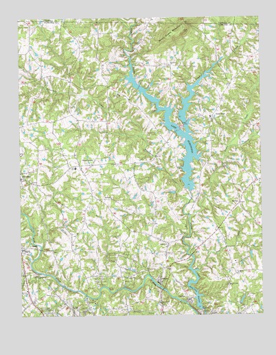
Lake Burlington, NC USGS Topographic Map
Click on map above to begin viewing in our Map Viewer.

This topographic map contains these locations and features:
Feature Name Type Latitude Longitude GNIS ID View Map
Archs Grove ChurchChurchN36.1379°W79.3914°980280View Map
Bethel ChurchChurchN36.1746°W79.4528°981164View Map
BirchwoodPopulated PlaceN36.1387°W79.4681°1003459View Map
British AcresPopulated PlaceN36.1354°W79.4628°1003460View Map
Bully Field Airport (historical)AirportN36.1555°W79.3981°2679124View Map
Buttermilk CreekStreamN36.1732°W79.4122°982339View Map
CarolinaPopulated PlaceN36.1318°W79.4125°1019534View Map
Clover GardenPopulated PlaceN36.1885°W79.4628°983297View Map
Deep CreekStreamN36.1437°W79.4100°984060View Map
Faucette Township Volunteer Fire Department Station 17BuildingN36.1518°W79.4600°2639081View Map
Faucette Township Volunteer Fire Department Station 7BuildingN36.1333°W79.4146°2638906View Map
GlencoePopulated PlaceN36.1390°W79.4278°1020446View Map
Glencoe Road ChurchChurchN36.1304°W79.4275°985728View Map
Green AcresPopulated PlaceN36.1457°W79.4509°1003528View Map
Hopedale ChurchChurchN36.1257°W79.4014°987045View Map
Indian Hills Country ClubLocaleN36.1393°W79.4461°1003527View Map
Jordan CreekStreamN36.1665°W79.4122°987775View Map
Lake BurlingtonReservoirN36.2024°W79.4193°982281View Map
Lake Burlington Sediment PoolReservoirN36.2235°W79.4114°1000373View Map
Lake Burlington Sediment Pool Number One DamDamN36.2235°W79.4114°1000374View Map
Lake Burlington Sediment Pool Number TwoReservoirN36.2318°W79.3997°1000390View Map
Lake Burlington Sediment Pool Number Two DamDamN36.2318°W79.3997°1000389View Map
Lake CammackReservoirN36.1768°W79.4114°1000264View Map
Lake Cammack DamDamN36.1768°W79.4114°1000265View Map
Lake View Estates PondReservoirN36.1314°W79.3853°1000138View Map
Lake View Estates Pond DamDamN36.1301°W79.3864°1000139View Map
LakeviewPopulated PlaceN36.1551°W79.4234°1021085View Map
Lakeview EstatesPopulated PlaceN36.1315°W79.3842°1003518View Map
McCrayPopulated PlaceN36.1724°W79.3861°1006291View Map
Mount Vernon ChurchChurchN36.2304°W79.4220°990610View Map
North Central Alamance Fire DepartmentBuildingN36.2044°W79.4156°2638433View Map
Old Stony Creek DamDamN36.1285°W79.4064°1000131View Map
Owens CreekStreamN36.1960°W79.3909°991755View Map
Riverside ChurchChurchN36.1537°W79.4911°993396View Map
Saint Lukes ChurchChurchN36.1407°W79.4436°994003View Map
Saint Pauls MissionChurchN36.1276°W79.4709°994106View Map
Stony Creek ChurchChurchN36.2182°W79.4486°995561View Map
Stony Creek MountainSummitN36.2446°W79.4145°995562View Map
Stony Creek ReservoirReservoirN36.1295°W79.4094°995563View Map
Toms CreekStreamN36.2012°W79.4134°996148View Map
Township 4-MortonCivilN36.1961°W79.4855°1026346View Map
Township 5-FaucetteCivilN36.1848°W79.4020°1026347View Map
Travis CreekStreamN36.1426°W79.4867°996213View Map
Union RidgePopulated PlaceN36.2076°W79.4000°1006397View Map
Western High SchoolSchoolN36.1532°W79.4986°997059View Map
Zion ChurchChurchN36.1265°W79.4636°997780View Map

Note: Coordinates in the location and feature list above are referenced to NAD83 datum.


Copyright (C) 2008-2025 Ryan Niemi / Sunset Dynamics ... All Rights Reserved