TopoQuest Logo
Do you find TopoQuest useful?
Help keep TopoQuest running and adding new maps/features by donating!
Bitcoin:  19c7KJd3qBynnjoSw5npx9KScwjBe4ifkT
Litecoin:  LXs6TkuXGGXo1vDsWCkWVdjQX94eUKd6ui
Home View Maps Find Maps Find Places Resources & Links


Burlington NE, North Carolina Topographic Map

USGS Map Title: Burlington NE, NC
USGS Map MRC: 36079B3
DRG (GeoTIFF) Download: o36079b3.tif


Neighboring USGS Topographic Map Quads:


  Cherry Grove, NC  
36079C4
 

  Anderson, NC  
36079C3
 

  Ridgeville, NC  
36079C2
 

  Lake Burlington, NC  
36079B4
 

  Burlington NE, NC  
36079B3
 

  Cedar Grove, NC  
36079B2
 

  Burlington, NC  
36079A4
 

  Mebane, NC  
36079A3
 

  Efland, NC  
36079A2


Map MRC Location:

N37°
W80°
N37°
W79°
H8 H7 H6 H5 H4 H3 H2 H1
G8 G7 G6 G5 G4 G3 G2 G1
F8 F7 F6 F5 F4 F3 F2 F1
E8 E7 E6 E5 E4 E3 E2 E1
D8 D7 D6 D5 D4 D3 D2 D1
C8 C7 C6 C5 C4 C3 C2 C1
B8 B7 B6 B5 B4 B3 B2 B1
A8 A7 A6 A5 A4 A3 A2 A1
N36°
W80°
N36°
W79°

Burlington NE, NC USGS 1:24K Topographic Map Preview:
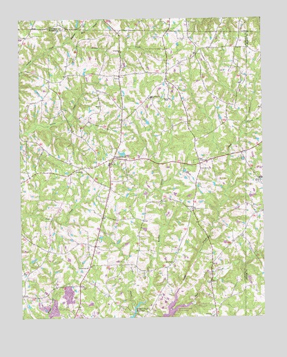
Burlington NE, NC USGS Topographic Map
Click on map above to begin viewing in our Map Viewer.

This topographic map contains these locations and features:
Feature Name Type Latitude Longitude GNIS ID View Map
Cross Roads ChurchChurchN36.1701°W79.2864°983787View Map
Frank CreekStreamN36.2065°W79.2586°985364View Map
Hughes Mill CreekStreamN36.2407°W79.3503°987233View Map
J R Vinson Lake DamDamN36.2468°W79.3281°1000417View Map
Jeffries Cross ChurchChurchN36.1865°W79.3431°987546View Map
Just CrossroadsPopulated PlaceN36.1893°W79.2822°1021008View Map
Kimes ChapelChurchN36.1396°W79.2764°987969View Map
Living Home ChurchChurchN36.2365°W79.3222°988820View Map
Longs ChapelChurchN36.1460°W79.3409°989016View Map
Martins ChapelChurchN36.2165°W79.2978°989407View Map
McCauley LakeReservoirN36.1936°W79.3219°1000310View Map
McCauley Lake DamDamN36.1935°W79.3214°1000311View Map
Miles ChapelChurchN36.1479°W79.2964°989851View Map
Mount Zion ChurchChurchN36.1821°W79.2522°990671View Map
Northeastern Alamance Volunteer Fire DepartmentBuildingN36.1870°W79.3277°2638801View Map
Occaneechi-Saponi State Designated Tribal Statistical AreaCensusN36.1750°W79.2575°2564991View Map
Patillo ChurchChurchN36.2135°W79.3334°991930View Map
Pleasant GrovePopulated PlaceN36.1921°W79.3267°992457View Map
Pleasant Grove SchoolSchoolN36.2171°W79.3070°992509View Map
Scrub CreekStreamN36.1304°W79.3181°994442View Map
Snow Hill ChurchChurchN36.1871°W79.2814°995070View Map
Stagg CreekStreamN36.1265°W79.2986°995395View Map
Township 11-Pleasant GroveCivilN36.1911°W79.3125°1026353View Map
Vinsons LakeReservoirN36.2468°W79.3281°1000418View Map
White Level ChurchChurchN36.1254°W79.2764°997143View Map

Note: Coordinates in the location and feature list above are referenced to NAD83 datum.


Copyright (C) 2008-2025 Ryan Niemi / Sunset Dynamics ... All Rights Reserved