TopoQuest Logo
Do you find TopoQuest useful?
Help keep TopoQuest running and adding new maps/features by donating!
Bitcoin:  19c7KJd3qBynnjoSw5npx9KScwjBe4ifkT
Litecoin:  LXs6TkuXGGXo1vDsWCkWVdjQX94eUKd6ui
Home View Maps Find Maps Find Places Resources & Links


Lake Burton, Georgia Topographic Map

USGS Map Title: Lake Burton, GA
USGS Map MRC: 34083G5
DRG (GeoTIFF) Download: o34083g5.tif


Neighboring USGS Topographic Map Quads:


  Macedonia, GA  
34083H6
 

  Hightower Bald, GA  
34083H5
 

  Dillard, GA  
34083H4
 

  Tray Mountain, GA  
34083G6
 

  Lake Burton, GA  
34083G5
 

  Tiger, GA  
34083G4
 

  Helen, GA  
34083F6
 

  Clarkesville NE, GA  
34083F5
 

  Tallulah Falls, GA  
34083F4


Map MRC Location:

N35°
W84°
N35°
W83°
H8 H7 H6 H5 H4 H3 H2 H1
G8 G7 G6 G5 G4 G3 G2 G1
F8 F7 F6 F5 F4 F3 F2 F1
E8 E7 E6 E5 E4 E3 E2 E1
D8 D7 D6 D5 D4 D3 D2 D1
C8 C7 C6 C5 C4 C3 C2 C1
B8 B7 B6 B5 B4 B3 B2 B1
A8 A7 A6 A5 A4 A3 A2 A1
N34°
W84°
N34°
W83°

Lake Burton, GA USGS 1:24K Topographic Map Preview:
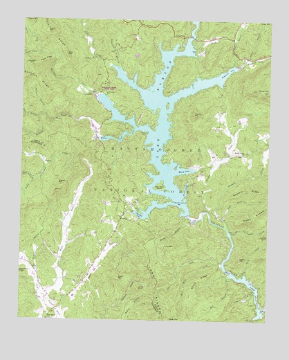
Lake Burton, GA USGS Topographic Map
Click on map above to begin viewing in our Map Viewer.

This topographic map contains these locations and features:
Feature Name Type Latitude Longitude GNIS ID View Map
Acorn CreekStreamN34.8615°W83.5366°326911View Map
Bad BranchStreamN34.7690°W83.5199°326986View Map
Baker BranchStreamN34.8154°W83.6107°326995View Map
Billy Goat IslandIslandN34.8065°W83.5546°327136View Map
Bramlet RidgeRidgeN34.8495°W83.6163°327207View Map
Bridge CreekStreamN34.7887°W83.5204°327218View Map
Burton (historical)Populated PlaceN34.8428°W83.5006°2575763View Map
Burton CemeteryCemeteryN34.8281°W83.5616°327302View Map
Burton Post Office (historical)Post OfficeN34.8431°W83.5506°2575769View Map
Canal BranchStreamN34.8590°W83.5104°327349View Map
Charlie MountainSummitN34.8356°W83.5377°327413View Map
Chastain BranchStreamN34.7551°W83.5810°328615View Map
Cherokee CoveBayN34.7937°W83.5646°327426View Map
Cliff CreekStreamN34.7515°W83.5052°327474View Map
Craig CemeteryCemeteryN34.8134°W83.5321°327544View Map
Crow CreekStreamN34.7734°W83.5229°327563View Map
Crow MountainSummitN34.7804°W83.5471°327566View Map
Dads CreekStreamN34.7923°W83.5224°327584View Map
Dads RidgeRidgeN34.7937°W83.5068°327585View Map
Dean LakeReservoirN34.8034°W83.6249°338987View Map
Dean Lake DamDamN34.8034°W83.6249°338986View Map
Dickenson BranchStreamN34.8559°W83.5766°327641View Map
Dicks CreekStreamN34.8559°W83.5802°327644View Map
Dicks Creek CoveBayN34.8445°W83.5638°330603View Map
Falls MountainSummitN34.8598°W83.6024°327798View Map
Frady CemeteryCemeteryN34.8623°W83.5374°327872View Map
Georgia State Fish HatcheryLocaleN34.8440°W83.5899°330866View Map
Gizzard BranchStreamN34.8179°W83.5968°327935View Map
Glassy MountainSummitN34.8456°W83.5004°356032View Map
Glassy Mountain LookoutLocaleN34.8448°W83.5007°330873View Map
Gomer BranchStreamN34.8595°W83.5879°327957View Map
Goshen BranchStreamN34.7695°W83.6191°330604View Map
Goshen CreekStreamN34.8181°W83.5952°327976View Map
Goshen MountainSummitN34.8056°W83.6057°327978View Map
Hellhole BranchStreamN34.8354°W83.6141°356250View Map
Hellhole MountainSummitN34.8562°W83.6210°356251View Map
High Valley Boys Club LakeReservoirN34.8101°W83.6249°339562View Map
High Valley Boys Club Lake DamDamN34.8101°W83.6249°339561View Map
High Valley BranchStreamN34.8079°W83.6177°328160View Map
Hills Boat DockLocaleN34.7945°W83.5685°351479View Map
Horse BranchStreamN34.7934°W83.5404°328217View Map
Jessie BranchStreamN34.8343°W83.6171°328319View Map
Jones BranchStreamN34.8576°W83.5185°328349View Map
King Sky Ranch AirportAirportN34.7681°W83.5931°351710View Map
La Counts CreekStreamN34.7865°W83.5179°328425View Map
Lake BurtonReservoirN34.8338°W83.5537°327303View Map
Lake Burton Game Management Area (historical)ParkN34.8626°W83.6166°328426View Map
Lakes Fire and RescueBuildingN34.7947°W83.5333°2604425View Map
Left Fork Soquee RiverStreamN34.7593°W83.6118°352087View Map
Long BranchStreamN34.7618°W83.5066°328616View Map
Long RidgeRidgeN34.7637°W83.5552°328637View Map
Magness CoveBayN34.8056°W83.5610°330605View Map
Mill CreekStreamN34.7962°W83.5668°328782View Map
Moates KnobSummitN34.7626°W83.5638°332330View Map
Moccasin CreekStreamN34.8437°W83.5868°328826View Map
Moccasin Creek CoveBayN34.8306°W83.5679°330606View Map
Moccasin Creek State ParkParkN34.8459°W83.5874°330867View Map
Mount Zion CemeteryCemeteryN34.8001°W83.5643°328910View Map
Mount Zion Church (historical)ChurchN34.7995°W83.5649°351483View Map
Muley MountainSummitN34.8715°W83.6132°328948View Map
Murray CoveBayN34.8129°W83.5424°328716View Map
Nacoochee DamDamN34.7551°W83.5013°330868View Map
North Fork Moccasin CreekStreamN34.8615°W83.6179°329049View Map
Perrin CoveBayN34.8048°W83.5418°329170View Map
Pigeon MountainSummitN34.7751°W83.5138°332663View Map
Pigpen RidgeRidgeN34.8579°W83.6138°329205View Map
Powell Gap School (historical)SchoolN34.8070°W83.5399°351488View Map
Providence SchoolSchoolN34.7501°W83.6113°329332View Map
Raper MountainSummitN34.7673°W83.5746°332792View Map
Right Fork Soquee RiverStreamN34.7590°W83.6121°335301View Map
Rocky Grove ChurchChurchN34.8195°W83.5127°329497View Map
Sawmill CreekStreamN34.7948°W83.5254°329611View Map
Sawmill RidgeRidgeN34.8048°W83.5099°329612View Map
Seals CreekStreamN34.7698°W83.5110°329631View Map
Seed LakeReservoirN34.7674°W83.5119°328966View Map
Shoal RidgeRidgeN34.7668°W83.5343°329684View Map
Slick Shoal CreekStreamN34.7740°W83.5241°329729View Map
Soque BranchStreamN34.8176°W83.5966°329759View Map
South Fork Moccasin CreekStreamN34.8615°W83.6182°329770View Map
Sportsman Club DamDamN34.7951°W83.5816°336881View Map
Sportsman Club LakeReservoirN34.7951°W83.5816°336882View Map
Stonecyphen CemeteryCemeteryN34.8445°W83.5824°329851View Map
Tallulah Persimmon Volunteer Fire DepartmentBuildingN34.8678°W83.5180°2604424View Map
Timpson CoveBayN34.8543°W83.5207°329997View Map
Timpson CreekStreamN34.8576°W83.5143°356592View Map
Wikle StorePopulated PlaceN34.7654°W83.5929°351456View Map
Wildcat CreekStreamN34.8270°W83.5863°330275View Map
Wildcat Creek CoveBayN34.8293°W83.5666°328444View Map
Wilson FallsFallsN34.8181°W83.5952°330610View Map
York RidgeRidgeN34.8673°W83.6093°330412View Map

Note: Coordinates in the location and feature list above are referenced to NAD83 datum.


Copyright (C) 2008-2025 Ryan Niemi / Sunset Dynamics ... All Rights Reserved