TopoQuest Logo
Do you find TopoQuest useful?
Help keep TopoQuest running and adding new maps/features by donating!
Bitcoin:  19c7KJd3qBynnjoSw5npx9KScwjBe4ifkT
Litecoin:  LXs6TkuXGGXo1vDsWCkWVdjQX94eUKd6ui
Home View Maps Find Maps Find Places Resources & Links


Clarkesville NE, Georgia Topographic Map

USGS Map Title: Clarkesville NE, GA
USGS Map MRC: 34083F5
DRG (GeoTIFF) Download: o34083f5.tif


Neighboring USGS Topographic Map Quads:


  Tray Mountain, GA  
34083G6
 

  Lake Burton, GA  
34083G5
 

  Tiger, GA  
34083G4
 

  Helen, GA  
34083F6
 

  Clarkesville NE, GA  
34083F5
 

  Tallulah Falls, GA  
34083F4
 

  Leaf, GA  
34083E6
 

  Clarkesville, GA  
34083E5
 

  Ayersville, GA  
34083E4


Map MRC Location:

N35°
W84°
N35°
W83°
H8 H7 H6 H5 H4 H3 H2 H1
G8 G7 G6 G5 G4 G3 G2 G1
F8 F7 F6 F5 F4 F3 F2 F1
E8 E7 E6 E5 E4 E3 E2 E1
D8 D7 D6 D5 D4 D3 D2 D1
C8 C7 C6 C5 C4 C3 C2 C1
B8 B7 B6 B5 B4 B3 B2 B1
A8 A7 A6 A5 A4 A3 A2 A1
N34°
W84°
N34°
W83°

Clarkesville NE, GA USGS 1:24K Topographic Map Preview:
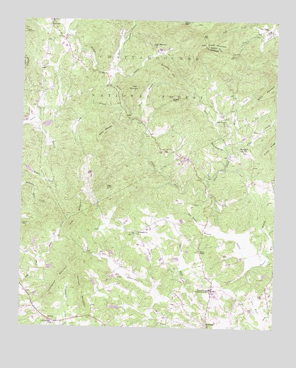
Clarkesville NE, GA USGS Topographic Map
Click on map above to begin viewing in our Map Viewer.

This topographic map contains these locations and features:
Feature Name Type Latitude Longitude GNIS ID View Map
Alec MountainSummitN34.6695°W83.5963°331015View Map
Alley CreekStreamN34.6998°W83.5160°326935View Map
Alleys ChapelChurchN34.6562°W83.5368°354286View Map
Alleys Chapel Methodist CemeteryCemeteryN34.6561°W83.5373°351329View Map
Amos CreekStreamN34.6529°W83.6160°326945View Map
Ann GapGapN34.7434°W83.5366°326956View Map
Arrendale Forest AirportAirportN34.6619°W83.5026°2770252View Map
BatesvillePopulated PlaceN34.7481°W83.6113°354479View Map
Beaverdam Creek Structure 42 DamDamN34.6334°W83.5766°338748View Map
Ben Tatum BranchStreamN34.6623°W83.5266°327069View Map
Bethlehem Baptist CemeteryCemeteryN34.6272°W83.5335°351338View Map
Bethlehem ChurchChurchN34.6268°W83.5327°354690View Map
Black Bear CreekStreamN34.7286°W83.5769°2094553View Map
Boys Mountain View CampLocaleN34.6945°W83.5221°351341View Map
Clarkesville DivisionCivilN34.6822°W83.5698°1936180View Map
College ParkPopulated PlaceN34.6415°W83.5304°351354View Map
Cool Springs CemeteryCemeteryN34.6259°W83.6088°351356View Map
Cool Springs ChurchChurchN34.6259°W83.6085°355289View Map
Cove BranchStreamN34.7159°W83.6066°327532View Map
Crow MountainSummitN34.7218°W83.5702°331486View Map
Deep CreekStreamN34.6284°W83.5043°327618View Map
Emma Griffin Hardman BridgeBridgeN34.6543°W83.5129°351372View Map
Flat Creek ChurchChurchN34.7459°W83.5035°355824View Map
Flat Creek MountainSummitN34.7390°W83.5316°355825View Map
Flat Creek School (historical)SchoolN34.7484°W83.5013°351473View Map
Grassy MountainSummitN34.7182°W83.5513°331852View Map
Habersham CountyCivilN34.6310°W83.5311°351383View Map
Habersham County Fire Department Station 15BuildingN34.6996°W83.5209°2604480View Map
Habersham County Fire Department Station 8BuildingN34.7483°W83.6122°2604403View Map
HarvestPopulated PlaceN34.6268°W83.6071°328084View Map
Harvest CemeteryCemeteryN34.6279°W83.6063°351392View Map
Harvest Christian ChurchChurchN34.6282°W83.6063°351393View Map
Harvest MountainSummitN34.6409°W83.5949°356216View Map
High KnobSummitN34.6815°W83.5832°328151View Map
Irwin MountainSummitN34.6654°W83.6227°332068View Map
Ivy BranchStreamN34.7073°W83.6168°328280View Map
Long BranchStreamN34.7145°W83.5757°328613View Map
Low GapGapN34.7359°W83.5210°328660View Map
Macedonia Baptist CemeteryCemeteryN34.6979°W83.5158°351410View Map
Macedonia ChurchChurchN34.6973°W83.5154°328682View Map
Macedonia SchoolSchoolN34.7015°W83.5224°328686View Map
Mack MountainSummitN34.7451°W83.6235°332299View Map
Moates BranchStreamN34.7415°W83.5774°328724View Map
Nerve BranchStreamN34.6951°W83.5232°328987View Map
North Georgia Technical CollegeSchoolN34.6388°W83.5295°329054View Map
North Habersham Middle SchoolSchoolN34.6358°W83.5120°351426View Map
Oakey CreekStreamN34.7287°W83.5810°329078View Map
Oakey MountainSummitN34.7498°W83.5454°332540View Map
Oakey Mountain Baptist ChurchChurchN34.7398°W83.5610°351428View Map
Oakey Mountain CemeteryCemeteryN34.7395°W83.5607°351429View Map
Oakey Mountain ChurchChurchN34.7395°W83.5607°329080View Map
PigeonStreamN34.6973°W83.5663°330753View Map
Porters Mill (historical)LocaleN34.6890°W83.5249°351435View Map
Porters Mill BranchStreamN34.6507°W83.5102°329307View Map
Providence Baptist ChurchChurchN34.7498°W83.6105°351436View Map
Raper CreekStreamN34.7293°W83.5796°329371View Map
Reservoir 13ReservoirN34.6534°W83.5799°336890View Map
Reservoir 18ReservoirN34.7084°W83.6182°336906View Map
Reservoir 22ReservoirN34.6868°W83.6182°336904View Map
Reservoir 42ReservoirN34.6332°W83.5779°338749View Map
Riverside School (historical)SchoolN34.7293°W83.5857°351440View Map
Sautee Creek Structure 18 DamDamN34.7084°W83.6182°336905View Map
Sautee Creek Structure 22 DamDamN34.6868°W83.6182°336903View Map
Sautee ValleyValleyN34.7070°W83.6221°1781985View Map
Sautee-Nacoochee ValleyValleyN34.7070°W83.6221°1781983View Map
SeedLocaleN34.7082°W83.5232°329636View Map
Seed Unity ChurchChurchN34.7073°W83.5252°329637View Map
Shoal BranchStreamN34.7084°W83.5666°329676View Map
Shoal CreekStreamN34.6784°W83.5329°329680View Map
Sillycook MountainSummitN34.7293°W83.5529°333053View Map
Soque Creek Structure 13 DamDamN34.6534°W83.5799°336889View Map
Stonepile CemeteryCemeteryN34.6637°W83.5674°351445View Map
Stonepile ChurchChurchN34.6637°W83.5671°329853View Map
Unity CemeteryCemeteryN34.7076°W83.5249°351450View Map
Whitworth BranchStreamN34.6976°W83.5252°330265View Map
Wildcat Volunteer Fire Department Station 11BuildingN34.6846°W83.5348°2604961View Map
Yellow MountainSummitN34.7043°W83.5841°333477View Map
Yellowbank MountainSummitN34.6501°W83.6005°330401View Map
Yoemans DamDamN34.6451°W83.6149°336883View Map
Yoemans LakeReservoirN34.6451°W83.6149°336884View Map

Note: Coordinates in the location and feature list above are referenced to NAD83 datum.


Copyright (C) 2008-2024 Ryan Niemi / Sunset Dynamics ... All Rights Reserved