TopoQuest Logo
Do you find TopoQuest useful?
Help keep TopoQuest running and adding new maps/features by donating!
Bitcoin:  19c7KJd3qBynnjoSw5npx9KScwjBe4ifkT
Litecoin:  LXs6TkuXGGXo1vDsWCkWVdjQX94eUKd6ui
Home View Maps Find Maps Find Places Resources & Links


Tallulah Falls, Georgia Topographic Map

USGS Map Title: Tallulah Falls, GA
USGS Map MRC: 34083F4
DRG (GeoTIFF) Download: o34083f4.tif


Neighboring USGS Topographic Map Quads:


  Lake Burton, GA  
34083G5
 

  Tiger, GA  
34083G4
 

  Rainy Mountain, GA  
34083G3
 

  Clarkesville NE, GA  
34083F5
 

  Tallulah Falls, GA  
34083F4
 

  Tugaloo Lake, GA  
34083F3
 

  Clarkesville, GA  
34083E5
 

  Ayersville, GA  
34083E4
 

  Toccoa, GA  
34083E3


Map MRC Location:

N35°
W84°
N35°
W83°
H8 H7 H6 H5 H4 H3 H2 H1
G8 G7 G6 G5 G4 G3 G2 G1
F8 F7 F6 F5 F4 F3 F2 F1
E8 E7 E6 E5 E4 E3 E2 E1
D8 D7 D6 D5 D4 D3 D2 D1
C8 C7 C6 C5 C4 C3 C2 C1
B8 B7 B6 B5 B4 B3 B2 B1
A8 A7 A6 A5 A4 A3 A2 A1
N34°
W84°
N34°
W83°

Tallulah Falls, GA USGS 1:24K Topographic Map Preview:
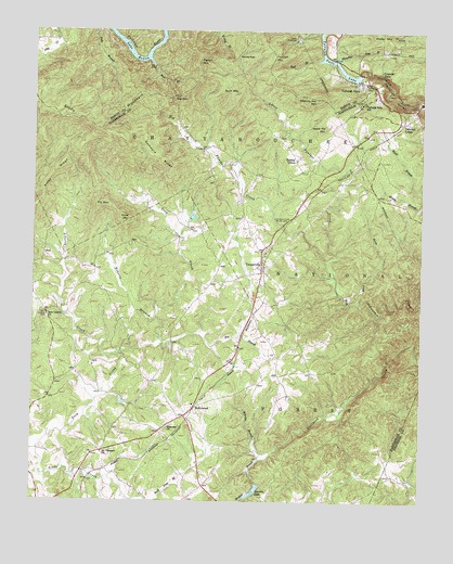
Tallulah Falls, GA USGS Topographic Map
Click on map above to begin viewing in our Map Viewer.

This topographic map contains these locations and features:
Feature Name Type Latitude Longitude GNIS ID View Map
Anandale (historical)Populated PlaceN34.6329°W83.4788°351333View Map
Apple Pie MountainSummitN34.7245°W83.4057°331046View Map
Bad BranchStreamN34.7426°W83.4088°326987View Map
Bear BranchStreamN34.7412°W83.4616°327025View Map
Bear GapGapN34.7326°W83.4549°327032View Map
Bible ChurchChurchN34.6570°W83.4613°351339View Map
Big Shoal MountainSummitN34.6882°W83.3827°351340View Map
Buck MountainSummitN34.7345°W83.4393°331268View Map
Camp ChattoogaLocaleN34.7481°W83.4154°327330View Map
Camp Yonach (historical)LocaleN34.6732°W83.3791°351343View Map
Cascade FallsFallsN34.7401°W83.3885°327372View Map
Cross Roads School (historical)SchoolN34.6584°W83.4221°351366View Map
Crow MountainSummitN34.6995°W83.4688°331487View Map
Deep CreekStreamN34.6304°W83.4785°327619View Map
Demoore RidgeRidgeN34.7168°W83.4596°327627View Map
Dixon CrossroadsPopulated PlaceN34.6254°W83.4974°331562View Map
Ebenezer ChurchChurchN34.6445°W83.4560°355636View Map
Ebenezer Methodist CemeteryCemeteryN34.6454°W83.4554°351371View Map
Fry BranchStreamN34.6676°W83.4585°327900View Map
Fry MountainSummitN34.7029°W83.4791°331778View Map
Glade CreekStreamN34.6315°W83.4971°327939View Map
Habersham County Emergency Medical Services NorthBuildingN34.6470°W83.4532°2625463View Map
Habersham County Fire Department Station 9BuildingN34.6471°W83.4532°2603618View Map
Hardman DamDamN34.6784°W83.4216°336879View Map
Hardman LakeReservoirN34.6783°W83.4195°336880View Map
Hickory Nut MountainSummitN34.7323°W83.4085°331963View Map
HollywoodPopulated PlaceN34.6495°W83.4474°332012View Map
Hollywood Baptist ChurchChurchN34.6495°W83.4538°351398View Map
Horse CreekStreamN34.6787°W83.3946°328220View Map
Lawson LakeReservoirN34.6279°W83.4283°328461View Map
Lawson Lake DamDamN34.6301°W83.4266°339555View Map
Lawson Lake Dam TwoDamN34.6298°W83.4274°336887View Map
Liberty CreekStreamN34.6643°W83.4724°328503View Map
Little Panther CreekStreamN34.6887°W83.4043°328567View Map
Mathis LakeReservoirN34.6368°W83.4682°339560View Map
Mathis Lake DamDamN34.6368°W83.4682°339559View Map
Mount Pleasant Baptist CemeteryCemeteryN34.6382°W83.4768°351416View Map
Mount Pleasant ChurchChurchN34.6382°W83.4771°318864View Map
Mount Zion Baptist CemeteryCemeteryN34.6918°W83.4252°351418View Map
Mount Zion Baptist ChurchChurchN34.6912°W83.4249°351417View Map
New Liberty ChurchChurchN34.6748°W83.4949°329017View Map
New Liberty Methodist CemeteryCemeteryN34.6746°W83.4955°328422View Map
Panther Creek CampgroundLocaleN34.6990°W83.4216°330742View Map
Panther Creek Picnic AreaLocaleN34.6995°W83.4199°329130View Map
Pigeon MountainSummitN34.7243°W83.4788°351433View Map
Pigeon MountainSummitN34.7431°W83.4457°332664View Map
Piney RidgeRidgeN34.7145°W83.4910°329236View Map
Reservoir 29ReservoirN34.6651°W83.4849°336892View Map
Reservoir 34ReservoirN34.6734°W83.4599°336894View Map
Reservoir 36ReservoirN34.6701°W83.4516°338747View Map
Roberts BranchStreamN34.6737°W83.4604°329450View Map
Rockin R AirportAirportN34.6764°W83.4231°2770253View Map
Shirley GrovePopulated PlaceN34.7162°W83.4152°333036View Map
Shirley Grove Baptist ChurchChurchN34.7159°W83.4154°351442View Map
Shirley Grove CemeteryCemeteryN34.7165°W83.4146°351443View Map
Slaughter Pen BranchStreamN34.7429°W83.4010°329727View Map
Soquee River Structure 29 DamDamN34.6651°W83.4849°336891View Map
Soquee River Structure 34 DamDamN34.6734°W83.4599°336893View Map
Soquee River Structure 36 DamDamN34.6701°W83.4516°338746View Map
Stony MountainSummitN34.7257°W83.4827°333137View Map
Tallulah FallsPopulated PlaceN34.7306°W83.3943°333182View Map
Tallulah Falls Baptist ChurchChurchN34.7343°W83.3913°351447View Map
Tallulah Falls Boarding SchoolSchoolN34.7305°W83.3950°329922View Map
Tallulah Falls Fire DepartmentBuildingN34.7366°W83.3957°2603708View Map
Tallulah Falls LakeReservoirN34.7410°W83.4021°329921View Map
Tallulah Falls Police DepartmentBuildingN34.7367°W83.3958°2733726View Map
Tallulah LodgeLocaleN34.7265°W83.3799°329924View Map
Tallulah MountainSummitN34.7434°W83.4224°333183View Map
Tallulah Park (historical)Populated PlaceN34.7154°W83.3957°351448View Map
Terrora Park CampgroundLocaleN34.7398°W83.3979°330741View Map
Toccoa Pumping StationLocaleN34.6490°W83.4029°330743View Map
Todd DamDamN34.6334°W83.4132°336885View Map
Todd LakeReservoirN34.6334°W83.4132°336886View Map
Town of Tallulah FallsCivilN34.7258°W83.3817°2406711View Map
TurnervillePopulated PlaceN34.6868°W83.4260°356600View Map
Turnerville Church of GodChurchN34.6820°W83.4277°351449View Map
Turnerville DivisionCivilN34.6679°W83.4214°1936600View Map
Walker BranchStreamN34.6365°W83.4249°330138View Map
Walkers Mill (historical)LocaleN34.6334°W83.4291°351453View Map
Waters LakeReservoirN34.7001°W83.4499°339554View Map
Waters Lake DamDamN34.7001°W83.4499°339553View Map
Wheeler BranchStreamN34.6751°W83.3891°351458View Map
Wheeler BranchStreamN34.6365°W83.4249°330233View Map
Woodville Elementary SchoolSchoolN34.6598°W83.4426°351459View Map
Worley GapGapN34.7434°W83.4343°330381View Map
WZLI-FM (Toccoa)TowerN34.7295°W83.4913°352801View Map

Note: Coordinates in the location and feature list above are referenced to NAD83 datum.


Copyright (C) 2008-2025 Ryan Niemi / Sunset Dynamics ... All Rights Reserved