TopoQuest Logo
Do you find TopoQuest useful?
Help keep TopoQuest running and adding new maps/features by donating!
Bitcoin:  19c7KJd3qBynnjoSw5npx9KScwjBe4ifkT
Litecoin:  LXs6TkuXGGXo1vDsWCkWVdjQX94eUKd6ui
Home View Maps Find Maps Find Places Resources & Links


Lake City East, Florida Topographic Map

USGS Map Title: Lake City East, FL
USGS Map MRC: 30082B5
DRG (GeoTIFF) Download: o30082b5.tif


Neighboring USGS Topographic Map Quads:


  White Springs East, FL  
30082C6
 

  Deep Creek, FL  
30082C5
 

  Big Gum Swamp, FL  
30082C4
 

  Lake City West, FL  
30082B6
 

  Lake City East, FL  
30082B5
 

  Olustee, FL  
30082B4
 

  Columbia, FL  
30082A6
 

  Ellisville, FL  
30082A5
 

  Lulu, FL  
30082A4


Map MRC Location:

N31°
W83°
N31°
W82°
H8 H7 H6 H5 H4 H3 H2 H1
G8 G7 G6 G5 G4 G3 G2 G1
F8 F7 F6 F5 F4 F3 F2 F1
E8 E7 E6 E5 E4 E3 E2 E1
D8 D7 D6 D5 D4 D3 D2 D1
C8 C7 C6 C5 C4 C3 C2 C1
B8 B7 B6 B5 B4 B3 B2 B1
A8 A7 A6 A5 A4 A3 A2 A1
N30°
W83°
N30°
W82°

Lake City East, FL USGS 1:24K Topographic Map Preview:
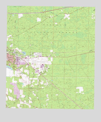
Lake City East, FL USGS Topographic Map
Click on map above to begin viewing in our Map Viewer.

This topographic map contains these locations and features:
Feature Name Type Latitude Longitude GNIS ID View Map
Bethel ChurchChurchN30.1266°W82.6223°305280View Map
Bethlehem ChurchChurchN30.1683°W82.5771°305282View Map
Church of God of Lake CityChurchN30.1888°W82.6248°2450134View Map
College Manor ChapelChurchN30.1905°W82.5648°306850View Map
Columbia Correctional InstitutionBuildingN30.1914°W82.5004°2450128View Map
Columbia Correctional Institution AnnexBuildingN30.1893°W82.5084°2450129View Map
Columbia CountyCivilN30.2242°W82.6215°306909View Map
Columbia County Sheriff's Office Operations CenterBuildingN30.1906°W82.5574°2755949View Map
Columbia Fire Control HeadquartersTowerN30.1852°W82.5960°306852View Map
Columbia High Adult Education SchoolSchoolN30.1775°W82.5671°306644View Map
Eastside Baptist ChurchChurchN30.1875°W82.6106°2450137View Map
Eastside Elementary SchoolSchoolN30.1846°W82.6061°305617View Map
First Full Gospel ChurchChurchN30.1832°W82.6069°2450144View Map
Fort White Adult Education SchoolSchoolN30.1761°W82.5671°306643View Map
Hideaway Mobile Home ParkPopulated PlaceN30.1826°W82.5952°2450118View Map
Hill Landing StripAirportN30.1755°W82.6062°309586View Map
Hudson Mobile Home ParkPopulated PlaceN30.1923°W82.5766°2450121View Map
Lake City Community CollegeSchoolN30.1744°W82.5673°305919View Map
Lake City Correctional FacilityBuildingN30.1927°W82.5075°2450130View Map
Lake City Country ClubLocaleN30.1769°W82.6140°305918View Map
Lake City Gateway AirportAirportN30.1789°W82.5737°309581View Map
Lantern Park Baptist ChurchChurchN30.1847°W82.6043°2450151View Map
Luther Thomas Mobile Home ParkPopulated PlaceN30.1810°W82.6098°2450127View Map
McColskeyPopulated PlaceN30.1891°W82.5623°294395View Map
Melrose Park Elementary SchoolSchoolN30.1857°W82.6248°306028View Map
Mount CarriePopulated PlaceN30.1952°W82.5037°306075View Map
NavairPopulated PlaceN30.1702°W82.5843°306849View Map
Naval Air Station Lake City (historical)MilitaryN30.1803°W82.5753°2100580View Map
New Mount Zion African Methodist Episcopal ChurchChurchN30.1894°W82.5926°2450157View Map
NewcoPopulated PlaceN30.1830°W82.6026°306848View Map
Oakview Mobile Home ParkPopulated PlaceN30.1870°W82.6124°2450123View Map
Osceola Ranger StationLocaleN30.1886°W82.5740°306996View Map
Osceola Work CenterLocaleN30.2161°W82.6021°306994View Map
Price CreekStreamN30.1575°W82.6104°306259View Map
Price Creek CemeteryCemeteryN30.1497°W82.5921°306260View Map
Rossi FieldAirportN30.1468°W82.5678°2676715View Map
Salvation Holiness ChurchChurchN30.1946°W82.6172°2450162View Map
Souls Harbor Church Of God In ChristChurchN30.1913°W82.6247°2450165View Map
Tabernacle Baptist ChurchChurchN30.1884°W82.6176°2450167View Map
Truvine CemeteryCemeteryN30.1858°W82.6046°306514View Map
Truvine ChurchChurchN30.1902°W82.5893°306515View Map
Victory TabernacleChurchN30.1911°W82.6248°306542View Map
WatertownPopulated PlaceN30.1925°W82.6146°306564View Map
Watertown Census Designated PlaceCensusN30.1854°W82.6024°2402987View Map
Watertown ChurchChurchN30.1936°W82.5748°306565View Map
Watertown LakeReservoirN30.1927°W82.5999°306566View Map
Wiggins Hunt CampLocaleN30.2450°W82.5082°306995View Map
WilburnPopulated PlaceN30.1908°W82.5787°306595View Map

Note: Coordinates in the location and feature list above are referenced to NAD83 datum.


Copyright (C) 2008-2025 Ryan Niemi / Sunset Dynamics ... All Rights Reserved