TopoQuest Logo
Do you find TopoQuest useful?
Help keep TopoQuest running and adding new maps/features by donating!
Bitcoin:  19c7KJd3qBynnjoSw5npx9KScwjBe4ifkT
Litecoin:  LXs6TkuXGGXo1vDsWCkWVdjQX94eUKd6ui
Home View Maps Find Maps Find Places Resources & Links


Barnesville, Missouri Topographic Map

USGS Map Title: Barnesville, MO
USGS Map MRC: 39092H5
DRG (GeoTIFF) Download: o39092h5.tif


Neighboring USGS Topographic Map Quads:


  Gifford, MO  
40092A6
 

  Millard, MO  
40092A5
 

  La Plata, MO  
40092A4
 

  Elmer, MO  
39092H6
 

  Barnesville, MO  
39092H5
 

  Atlanta, MO  
39092H4
 

  New Cambria East, MO  
39092G6
 

  Bevier North, MO  
39092G5
 

  Axtell, MO  
39092G4


Map MRC Location:

N40°
W93°
N40°
W92°
H8 H7 H6 H5 H4 H3 H2 H1
G8 G7 G6 G5 G4 G3 G2 G1
F8 F7 F6 F5 F4 F3 F2 F1
E8 E7 E6 E5 E4 E3 E2 E1
D8 D7 D6 D5 D4 D3 D2 D1
C8 C7 C6 C5 C4 C3 C2 C1
B8 B7 B6 B5 B4 B3 B2 B1
A8 A7 A6 A5 A4 A3 A2 A1
N39°
W93°
N39°
W92°

Barnesville, MO USGS 1:24K Topographic Map Preview:
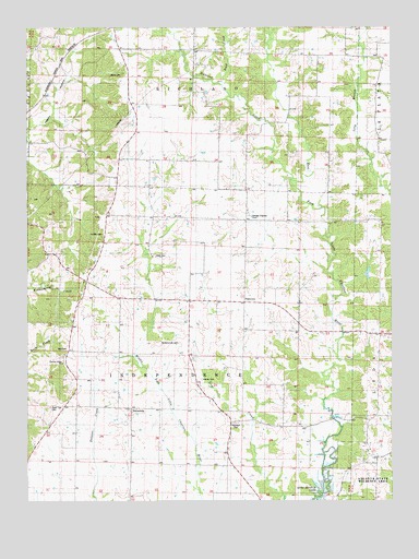
Barnesville, MO USGS Topographic Map
Click on map above to begin viewing in our Map Viewer.

This topographic map contains these locations and features:
Feature Name Type Latitude Longitude GNIS ID View Map
Atlanta State Wildlife AreaParkN39.8781°W92.5069°713469View Map
Atterberry School (historical)SchoolN39.8928°W92.6191°741616View Map
BarnesvillePopulated PlaceN39.8995°W92.5899°740659View Map
Buck CreekStreamN39.9850°W92.5582°714961View Map
Bunch SchoolSchoolN39.9359°W92.6046°741614View Map
Chariton Ridge ChurchChurchN39.9114°W92.6135°715735View Map
CottagePopulated PlaceN39.9834°W92.5816°740158View Map
Cottage Post OfficePost OfficeN39.9500°W92.5816°759899View Map
George Baake DamDamN39.9384°W92.5085°760731View Map
George Baake LakeReservoirN39.9350°W92.5083°760732View Map
Happy HollowValleyN39.9723°W92.6244°719070View Map
Hayner CemeteryCemeteryN39.9070°W92.5657°719263View Map
Hertzler CemeteryCemeteryN39.9456°W92.5994°719406View Map
Hockensmith CemeteryCemeteryN39.9167°W92.5732°719655View Map
Hopewell CemeteryCemeteryN39.8956°W92.5543°719797View Map
Hopewell School (historical)SchoolN39.8959°W92.5549°741618View Map
Little Zion Church (historical)ChurchN39.9578°W92.5966°741609View Map
McNeely School (historical)SchoolN39.9495°W92.5385°741612View Map
Murry CemeteryCemeteryN39.9875°W92.5924°723085View Map
Murry SchoolSchoolN39.9803°W92.5930°741608View Map
Nash School (historical)SchoolN39.9228°W92.5377°741615View Map
Osborne School (historical)SchoolN39.8923°W92.5894°741617View Map
PlainviewPopulated PlaceN39.9273°W92.5507°741157View Map
Quail Trap CemeteryCemeteryN39.8997°W92.6174°725020View Map
Richland CreekStreamN39.9595°W92.5344°725275View Map
Steel CemeteryCemeteryN39.9400°W92.5819°727047View Map
Steel School (historical)SchoolN39.9370°W92.5749°741613View Map
Still CemeteryCemeteryN39.9150°W92.6119°727099View Map
Township of IndependenceCivilN39.9138°W92.5698°766965View Map
Township of RichlandCivilN39.9976°W92.5671°766975View Map
Union Ridge SchoolSchoolN39.9753°W92.5402°741611View Map

Note: Coordinates in the location and feature list above are referenced to NAD83 datum.


Copyright (C) 2008-2025 Ryan Niemi / Sunset Dynamics ... All Rights Reserved