TopoQuest Logo
Do you find TopoQuest useful?
Help keep TopoQuest running and adding new maps/features by donating!
Bitcoin:  19c7KJd3qBynnjoSw5npx9KScwjBe4ifkT
Litecoin:  LXs6TkuXGGXo1vDsWCkWVdjQX94eUKd6ui
Home View Maps Find Maps Find Places Resources & Links


Gifford, Missouri Topographic Map

USGS Map Title: Gifford, MO
USGS Map MRC: 40092A6
DRG (GeoTIFF) Download: o40092a6.tif


Neighboring USGS Topographic Map Quads:


  Pure Air, MO  
40092B7
 

  Novinger, MO  
40092B6
 

  Kirksville, MO  
40092B5
 

  Nind, MO  
40092A7
 

  Gifford, MO  
40092A6
 

  Millard, MO  
40092A5
 

  New Boston, MO  
39092H7
 

  Elmer, MO  
39092H6
 

  Barnesville, MO  
39092H5


Map MRC Location:

N41°
W93°
N41°
W92°
H8 H7 H6 H5 H4 H3 H2 H1
G8 G7 G6 G5 G4 G3 G2 G1
F8 F7 F6 F5 F4 F3 F2 F1
E8 E7 E6 E5 E4 E3 E2 E1
D8 D7 D6 D5 D4 D3 D2 D1
C8 C7 C6 C5 C4 C3 C2 C1
B8 B7 B6 B5 B4 B3 B2 B1
A8 A7 A6 A5 A4 A3 A2 A1
N40°
W93°
N40°
W92°

Gifford, MO USGS 1:24K Topographic Map Preview:
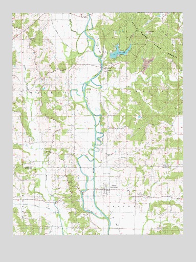
Gifford, MO USGS Topographic Map
Click on map above to begin viewing in our Map Viewer.

This topographic map contains these locations and features:
Feature Name Type Latitude Longitude GNIS ID View Map
Airway Beacon (historical)TowerN40.0281°W92.7099°742709View Map
Canaday CemeteryCemeteryN40.0684°W92.6294°715329View Map
Community ChurchChurchN40.0964°W92.6771°716158View Map
Curtis School (historical)SchoolN40.0606°W92.6649°742708View Map
Easley School (historical)SchoolN40.0209°W92.6444°742711View Map
Elm CreekStreamN40.0981°W92.6844°717509View Map
GiffordPopulated PlaceN40.0256°W92.6816°736301View Map
Goose CreekStreamN40.1034°W92.7024°718591View Map
Hays School (historical)SchoolN40.0584°W92.7194°742706View Map
Hog CreekStreamN40.1125°W92.7002°719676View Map
Indian CreekStreamN40.0425°W92.6899°720114View Map
Indian Hill CemeteryCemeteryN40.0447°W92.6807°720136View Map
Indian Hill Cemetery (historical)CemeteryN40.0595°W92.6802°742707View Map
Lindersville (historical)Populated PlaceN40.0945°W92.7055°759881View Map
Lindersville Post Office (historical)Post OfficeN40.0945°W92.7055°1930469View Map
Little Walnut CreekStreamN40.0128°W92.7167°721355View Map
Little Walnut CreekStreamN40.0487°W92.7358°721356View Map
Lone Star SchoolSchoolN40.0214°W92.7085°742710View Map
Mount Carmel ChurchChurchN40.0464°W92.7224°722737View Map
Mount Zion SchoolSchoolN40.0942°W92.7185°742705View Map
Sheridan Grove CemeteryCemeteryN40.0228°W92.6538°726336View Map
SimlerPopulated PlaceN40.1225°W92.6955°738307View Map
Southwestern Adair County Rural Fire District Station 2BuildingN40.0935°W92.6802°2620748View Map
Spring LakeReservoirN40.1027°W92.6719°758344View Map
Spring Lake DamDamN40.1000°W92.6785°760410View Map
Sugar CreekStreamN40.0845°W92.6952°727233View Map
Sugar Creek School (historical)SchoolN40.1123°W92.6263°742704View Map
Sugar Creek State ForestForestN40.1084°W92.6424°727244View Map
Union TempleChurchN40.1100°W92.7366°728049View Map
Village of South GiffordCivilN40.0257°W92.6831°2399847View Map
YarrowPopulated PlaceN40.0939°W92.6805°741375View Map

Note: Coordinates in the location and feature list above are referenced to NAD83 datum.


Copyright (C) 2008-2024 Ryan Niemi / Sunset Dynamics ... All Rights Reserved