TopoQuest Logo
Do you find TopoQuest useful?
Help keep TopoQuest running and adding new maps/features by donating!
Bitcoin:  19c7KJd3qBynnjoSw5npx9KScwjBe4ifkT
Litecoin:  LXs6TkuXGGXo1vDsWCkWVdjQX94eUKd6ui
Home View Maps Find Maps Find Places Resources & Links


Rose Bud, Arkansas Topographic Map

USGS Map Title: Rose Bud, AR
USGS Map MRC: 35092C1
DRG (GeoTIFF) Download: o35092c1.tif


Neighboring USGS Topographic Map Quads:


  Quitman, AR  
35092D2
 

  Heber Springs, AR  
35092D1
 

  West Pangburn, AR  
35091D8
 

  Barney, AR  
35092C2
 

  Rose Bud, AR  
35092C1
 

  Sidon, AR  
35091C8
 

  Enola, AR  
35092B2
 

  Mount Vernon, AR  
35092B1
 

  Floyd, AR  
35091B8


Map MRC Location:

N36°
W93°
N36°
W92°
H8 H7 H6 H5 H4 H3 H2 H1
G8 G7 G6 G5 G4 G3 G2 G1
F8 F7 F6 F5 F4 F3 F2 F1
E8 E7 E6 E5 E4 E3 E2 E1
D8 D7 D6 D5 D4 D3 D2 D1
C8 C7 C6 C5 C4 C3 C2 C1
B8 B7 B6 B5 B4 B3 B2 B1
A8 A7 A6 A5 A4 A3 A2 A1
N35°
W93°
N35°
W92°

Rose Bud, AR USGS 1:24K Topographic Map Preview:
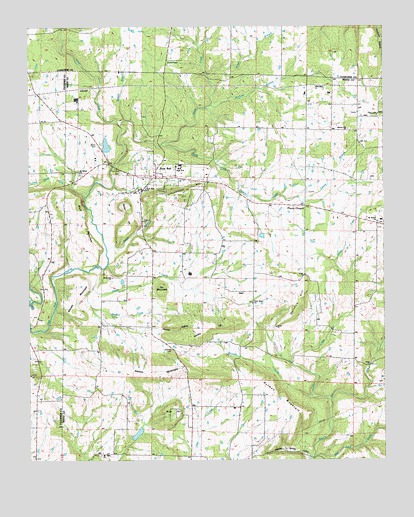
Rose Bud, AR USGS Topographic Map
Click on map above to begin viewing in our Map Viewer.

This topographic map contains these locations and features:
Feature Name Type Latitude Longitude GNIS ID View Map
Arkansas Noname 23 DamDamN35.2584°W92.0835°79779View Map
Bad Luck CreekStreamN35.2509°W92.0249°46003View Map
Bethesda ChurchChurchN35.3029°W92.0957°46465View Map
Blakey BranchStreamN35.3481°W92.0915°46705View Map
Blue HillSummitN35.2659°W92.0729°57398View Map
Bluff MountainSummitN35.3242°W92.1074°57401View Map
Boyd BranchStreamN35.3612°W92.0621°46867View Map
Cedar CreekStreamN35.2670°W92.0190°47578View Map
Cedar CreekStreamN35.3059°W92.1010°47580View Map
Clay BranchStreamN35.2815°W92.0018°47813View Map
Daniels CreekStreamN35.2687°W92.0257°48351View Map
Dripping Springs HollowValleyN35.2509°W92.0254°48608View Map
Gin MountainSummitN35.2987°W92.0782°57819View Map
Graham BranchStreamN35.3529°W92.0613°49536View Map
HartPopulated PlaceN35.2987°W92.0518°77136View Map
Holman MountainSummitN35.2645°W92.0329°57936View Map
Jones CreekStreamN35.3412°W92.0782°50733View Map
Liberty Hill ChurchChurchN35.3456°W92.0124°51117View Map
Martin CemeteryCemeteryN35.3642°W92.0757°51706View Map
Moon CemeteryCemeteryN35.3409°W92.1007°52148View Map
Mosely MountainSummitN35.2992°W92.1051°58218View Map
Mount Bethel Freewill Baptist ChurchChurchN35.3179°W92.0018°77703View Map
Mount Olive ChurchChurchN35.2518°W92.0999°52357View Map
Piney CreekStreamN35.3465°W92.0924°53479View Map
Plants ChapelLocaleN35.3234°W92.0288°53518View Map
Potter BranchStreamN35.3112°W92.0979°53727View Map
Potter HillSummitN35.3237°W92.0915°58418View Map
Rose BudPopulated PlaceN35.3315°W92.0813°54191View Map
Rose Bud CemeteryCemeteryN35.3329°W92.0924°54192View Map
Rose Bud Elementary SchoolSchoolN35.3352°W92.0718°65108View Map
Rose Bud High SchoolSchoolN35.3342°W92.0720°65109View Map
Rose Bud Post OfficePost OfficeN35.3318°W92.0883°84974View Map
Rose Bud Volunteer Fire DepartmentBuildingN35.3311°W92.0678°2117046View Map
Rosebud Police DepartmentBuildingN35.3312°W92.0685°2118765View Map
Saint Marys ChurchChurchN35.3326°W92.1071°54417View Map
Schoolhouse HillSummitN35.3265°W92.0699°54624View Map
Spring BranchStreamN35.3259°W92.0307°55082View Map
Starkey CemeteryCemeteryN35.2817°W92.0754°55168View Map
Starkey HillSummitN35.2890°W92.0565°58682View Map
Starkey HollowValleyN35.2898°W92.0946°55170View Map
Starkey MountainSummitN35.2754°W92.0810°58683View Map
Town of Rose BudCivilN35.3255°W92.0802°2407243View Map
Township of KentuckyCivilN35.3174°W92.0613°69843View Map
Turnip (historical)Populated PlaceN35.3181°W92.0026°65120View Map
Walnut CreekStreamN35.2998°W92.1026°55996View Map
Wingert Lake DamDamN35.3451°W92.0968°79777View Map
Wingert ReservoirReservoirN35.3451°W92.0968°79778View Map
Wortham HillSummitN35.2956°W92.0299°58918View Map

Note: Coordinates in the location and feature list above are referenced to NAD83 datum.


Copyright (C) 2008-2025 Ryan Niemi / Sunset Dynamics ... All Rights Reserved