TopoQuest Logo
Do you find TopoQuest useful?
Help keep TopoQuest running and adding new maps/features by donating!
Bitcoin:  19c7KJd3qBynnjoSw5npx9KScwjBe4ifkT
Litecoin:  LXs6TkuXGGXo1vDsWCkWVdjQX94eUKd6ui
Home View Maps Find Maps Find Places Resources & Links


Lake Milton, Ohio Topographic Map

USGS Map Title: Lake Milton, OH
USGS Map MRC: 41080A8
DRG (GeoTIFF) Download: o41080a8.tif


Neighboring USGS Topographic Map Quads:


  Windham, OH  
41081B1
 

  Newton Falls, OH  
41080B8
 

  Warren, OH  
41080B7
 

  Deerfield, OH  
41081A1
 

  Lake Milton, OH  
41080A8
 

  Canfield, OH  
41080A7
 

  Alliance, OH  
40081H1
 

  Damascus, OH  
40080H8
 

  Salem, OH  
40080H7


Map MRC Location:

N42°
W81°
N42°
W80°
H8 H7 H6 H5 H4 H3 H2 H1
G8 G7 G6 G5 G4 G3 G2 G1
F8 F7 F6 F5 F4 F3 F2 F1
E8 E7 E6 E5 E4 E3 E2 E1
D8 D7 D6 D5 D4 D3 D2 D1
C8 C7 C6 C5 C4 C3 C2 C1
B8 B7 B6 B5 B4 B3 B2 B1
A8 A7 A6 A5 A4 A3 A2 A1
N41°
W81°
N41°
W80°

Lake Milton, OH USGS 1:24K Topographic Map Preview:
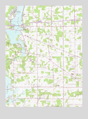
Lake Milton, OH USGS Topographic Map
Click on map above to begin viewing in our Map Viewer.

This topographic map contains these locations and features:
Feature Name Type Latitude Longitude GNIS ID View Map
Berlin CenterPopulated PlaceN41.0245°W80.9476°1056221View Map
Berlin Center StationLocaleN41.0103°W80.9443°1064421View Map
Berlin Township Fire DepartmentBuildingN41.0243°W80.9495°2549631View Map
BlancoPopulated PlaceN41.0856°W80.9595°1062650View Map
Blanco Post Office (historical)Post OfficeN41.0862°W80.9595°2035631View Map
Canyon ParkPopulated PlaceN41.0787°W80.9954°1048581View Map
Charley Run CreekStreamN41.0931°W80.9684°1066641View Map
Circle C AirportAirportN41.0408°W80.9849°1082497View Map
Craig BeachPopulated PlaceN41.1170°W80.9834°1048638View Map
Craig Beach Post Office (historical)Post OfficeN41.1170°W80.9834°1926733View Map
East BranchStreamN41.1145°W80.9295°1039967View Map
Eckis CemeteryCemeteryN41.0834°W80.9251°1040067View Map
Ellsworth StationLocaleN41.0364°W80.8859°1040156View Map
FredericksburgPopulated PlaceN41.0673°W80.9770°1064682View Map
Hawkins LakeLakeN41.0066°W80.9329°1041408View Map
Heiser CornersLocaleN41.0645°W80.9481°1056325View Map
Helsel CornersLocaleN41.0239°W80.9865°1041477View Map
Interchange 54CrossingN41.1042°W80.9490°1051832View Map
Interchange 57CrossingN41.1073°W80.8873°1051833View Map
Lake MiltonReservoirN41.0967°W80.9811°1043393View Map
Lake MiltonPopulated PlaceN41.0995°W80.9704°1048896View Map
Lake Milton Census Designated PlaceCensusN41.0961°W80.9812°2628919View Map
Lake Milton Elementary SchoolSchoolN41.1001°W80.9648°1081665View Map
Lake Milton Mobile Home ParkPopulated PlaceN41.0686°W80.9756°2513522View Map
Lake Milton Post OfficePost OfficeN41.1001°W80.9706°2035703View Map
Lake Milton Rescue SquadBuildingN41.1158°W80.9850°2733203View Map
Lake Milton TempleChurchN41.0928°W80.9473°1056893View Map
Mill Creek Recreation AreaParkN41.0070°W80.9979°1043330View Map
Milton Township Fire DepartmentBuildingN41.1004°W80.9555°2549694View Map
Mount Moriah Lutheran ChurchChurchN41.0526°W80.9481°1043583View Map
North Berlin CemeteryCemeteryN41.0525°W80.9473°1043914View Map
RosemontPopulated PlaceN41.0634°W80.8865°1062992View Map
Rosemont Post Office (historical)Post OfficeN41.0639°W80.8859°2035630View Map
Saint Catherines ChurchChurchN41.1081°W80.9920°1045422View Map
Sandy Knoll Horse FarmLocaleN41.0947°W80.9236°2651263View Map
Schrader CornersLocaleN41.0762°W80.9281°1056510View Map
Shillings MillPopulated PlaceN41.0584°W80.9859°1063013View Map
ShiltownPopulated PlaceN41.0581°W80.9273°1065319View Map
Smith CornersLocaleN41.0820°W80.9479°1056522View Map
Sunset BeachPopulated PlaceN41.1137°W80.9718°1046866View Map
Township of BerlinCivilN41.0250°W80.9538°1086557View Map
Township of MiltonCivilN41.0982°W80.9541°1086566View Map
Turkey Broth CreekStreamN41.0098°W80.9806°1047193View Map
Vaughn CemeteryCemeteryN41.1012°W80.9873°1047432View Map
Village of Craig BeachCivilN41.1160°W80.9827°2398643View Map
West Berlin CemeteryCemeteryN41.0242°W80.9573°1047733View Map
Western Reserve High SchoolSchoolN41.0262°W80.9126°1047818View Map
Western Reserve Middle SchoolSchoolN41.0251°W80.9515°1051861View Map
Wolf CornersLocaleN41.0659°W80.9623°1056580View Map

Note: Coordinates in the location and feature list above are referenced to NAD83 datum.


Copyright (C) 2008-2025 Ryan Niemi / Sunset Dynamics ... All Rights Reserved