TopoQuest Logo
Do you find TopoQuest useful?
Help keep TopoQuest running and adding new maps/features by donating!
Bitcoin:  19c7KJd3qBynnjoSw5npx9KScwjBe4ifkT
Litecoin:  LXs6TkuXGGXo1vDsWCkWVdjQX94eUKd6ui
Home View Maps Find Maps Find Places Resources & Links


Windham, Ohio Topographic Map

USGS Map Title: Windham, OH
USGS Map MRC: 41081B1
DRG (GeoTIFF) Download: o41081b1.tif


Neighboring USGS Topographic Map Quads:


  Mantua, OH  
41081C2
 

  Garrettsville, OH  
41081C1
 

  Southington, OH  
41080C8
 

  Ravenna, OH  
41081B2
 

  Windham, OH  
41081B1
 

  Newton Falls, OH  
41080B8
 

  Atwater, OH  
41081A2
 

  Deerfield, OH  
41081A1
 

  Lake Milton, OH  
41080A8


Map MRC Location:

N42°
W82°
N42°
W81°
H8 H7 H6 H5 H4 H3 H2 H1
G8 G7 G6 G5 G4 G3 G2 G1
F8 F7 F6 F5 F4 F3 F2 F1
E8 E7 E6 E5 E4 E3 E2 E1
D8 D7 D6 D5 D4 D3 D2 D1
C8 C7 C6 C5 C4 C3 C2 C1
B8 B7 B6 B5 B4 B3 B2 B1
A8 A7 A6 A5 A4 A3 A2 A1
N41°
W82°
N41°
W81°

Windham, OH USGS 1:24K Topographic Map Preview:
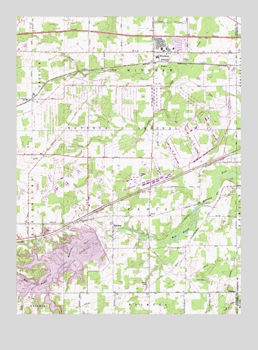
Windham, OH USGS Topographic Map
Click on map above to begin viewing in our Map Viewer.

This topographic map contains these locations and features:
Feature Name Type Latitude Longitude GNIS ID View Map
Bossow Airport (historical)AirportN41.2493°W81.1017°1082708View Map
Church of ChristChurchN41.2478°W81.0353°2513768View Map
Church of the NazareneChurchN41.2347°W81.0394°2513769View Map
Congregational Church of ChristChurchN41.2381°W81.0494°2513770View Map
Dreamland AcresLocaleN41.2356°W81.0225°2724358View Map
Dunn FieldAirportN41.1579°W81.0039°1082898View Map
East Boat RampLocaleN41.1476°W81.0859°1962898View Map
East Davis (historical)Populated PlaceN41.1381°W81.1123°1067184View Map
East Elementary SchoolSchoolN41.2367°W81.0379°1058237View Map
First Baptist ChurchChurchN41.2344°W81.0128°2513771View Map
First Church of GodChurchN41.2378°W81.0483°2513772View Map
Four Leaf FarmLocaleN41.2467°W81.1219°2724355View Map
Greenleaf School (historical)SchoolN41.1920°W81.1129°1058241View Map
Greenleafs Corners (historical)Populated PlaceN41.1920°W81.1095°1067186View Map
Harrisport (historical)Populated PlaceN41.1814°W81.0098°1067187View Map
Hawley CemeteryCemeteryN41.1509°W81.0318°1041411View Map
Hickory IslandIslandN41.1517°W81.0973°1962900View Map
Katherine Thomas Elementary SchoolSchoolN41.2367°W81.0443°1058238View Map
Longacre FarmsLocaleN41.1483°W81.0314°2724339View Map
Marys LakeLakeN41.1378°W81.0520°1043042View Map
McClintocksburgPopulated PlaceN41.1698°W81.0156°1065727View Map
Michael J Kirwan DamDamN41.1556°W81.0748°1077659View Map
Morningstar FarmLocaleN41.2211°W81.1136°2724354View Map
ParisPopulated PlaceN41.1664°W81.0512°1062932View Map
Paris Township Fire DepartmentBuildingN41.1667°W81.0532°2549166View Map
PritchardPopulated PlaceN41.1342°W81.0081°1062957View Map
Pritchard Post Office (historical)Post OfficeN41.1348°W81.0081°2055531View Map
Purdys Trailer ParkPopulated PlaceN41.2344°W81.0433°2513655View Map
Ravenna Training and Logistics SiteMilitaryN41.1973°W81.0843°2512440View Map
Red Clover FarmLocaleN41.1514°W81.0297°2724346View Map
Rocky Meadow FarmsLocaleN41.2361°W81.0733°2724356View Map
Saint Josephs CemeteryCemeteryN41.1754°W81.0090°1045570View Map
Sand CreekStreamN41.2289°W81.0318°1045931View Map
Silver Creek BayBayN41.1303°W81.1051°1962901View Map
Township of ParisCivilN41.1677°W81.0507°1086835View Map
Township of WindhamCivilN41.2161°W81.0508°1086843View Map
Village of WindhamCivilN41.2375°W81.0373°2399712View Map
WaylandPopulated PlaceN41.1606°W81.0712°1065458View Map
Wayland Community ChurchChurchN41.1595°W81.0718°1061990View Map
Wayland Post OfficePost OfficeN41.1612°W81.0707°2043847View Map
Welsh CemeteryCemeteryN41.1337°W81.0509°1047676View Map
West Branch State ParkParkN41.1431°W81.1082°1058212View Map
WindhamPopulated PlaceN41.2351°W81.0493°1061794View Map
Windham Elementary SchoolSchoolN41.2337°W81.0465°1058239View Map
Windham High SchoolSchoolN41.2331°W81.0468°1058240View Map
Windham Police DepartmentBuildingN41.2355°W81.0439°2732681View Map
Windham Station (historical)LocaleN41.2309°W81.0490°1067194View Map
Windham Volunteer Fire DepartmentBuildingN41.2354°W81.0444°2549667View Map
Windham Water Treatment PlantLocaleN41.2383°W81.0506°2740868View Map

Note: Coordinates in the location and feature list above are referenced to NAD83 datum.


Copyright (C) 2008-2025 Ryan Niemi / Sunset Dynamics ... All Rights Reserved