TopoQuest Logo
Do you find TopoQuest useful?
Help keep TopoQuest running and adding new maps/features by donating!
Bitcoin:  19c7KJd3qBynnjoSw5npx9KScwjBe4ifkT
Litecoin:  LXs6TkuXGGXo1vDsWCkWVdjQX94eUKd6ui
Home View Maps Find Maps Find Places Resources & Links


Lake Murvaul, Texas Topographic Map

USGS Map Title: Lake Murvaul, TX
USGS Map MRC: 32094A4
DRG (GeoTIFF) Download: o32094a4.tif


Neighboring USGS Topographic Map Quads:


  Fair Play, TX  
32094B5
 

  Beckville, TX  
32094B4
 

  Carthage, TX  
32094B3
 

  Long Branch, TX  
32094A5
 

  Lake Murvaul, TX  
32094A4
 

  Gary, TX  
32094A3
 

  Caledonia, TX  
31094H5
 

  Timpson, TX  
31094H4
 

  Tenaha West, TX  
31094H3


Map MRC Location:

N33°
W95°
N33°
W94°
H8 H7 H6 H5 H4 H3 H2 H1
G8 G7 G6 G5 G4 G3 G2 G1
F8 F7 F6 F5 F4 F3 F2 F1
E8 E7 E6 E5 E4 E3 E2 E1
D8 D7 D6 D5 D4 D3 D2 D1
C8 C7 C6 C5 C4 C3 C2 C1
B8 B7 B6 B5 B4 B3 B2 B1
A8 A7 A6 A5 A4 A3 A2 A1
N32°
W95°
N32°
W94°

Lake Murvaul, TX USGS 1:24K Topographic Map Preview:
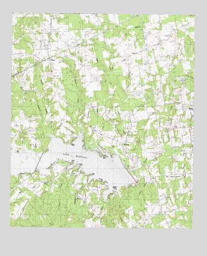
Lake Murvaul, TX USGS Topographic Map
Click on map above to begin viewing in our Map Viewer.

This topographic map contains these locations and features:
Feature Name Type Latitude Longitude GNIS ID View Map
Beck CreekStreamN32.0277°W94.4799°1372462View Map
Beck CreekStreamN32.0232°W94.4844°1350782View Map
Bethlehem ChurchChurchN32.0988°W94.4205°1351974View Map
Boy Scouts of America CampLocaleN32.0266°W94.4146°1352775View Map
Bull CreekStreamN32.0471°W94.4902°1372817View Map
BuncomePopulated PlaceN32.0491°W94.4238°1379475View Map
Caney CreekStreamN32.0174°W94.4341°1353740View Map
Carrico CemeteryCemeteryN32.0560°W94.4269°1353860View Map
ClaytonPopulated PlaceN32.0982°W94.4749°1379556View Map
Clayton Post OfficePost OfficeN32.0980°W94.4759°2731111View Map
Clayton Volunteer Fire DepartmentBuildingN32.0985°W94.4787°2655257View Map
Colo CreekStreamN32.0346°W94.4096°1354806View Map
DanielsPopulated PlaceN32.0660°W94.3752°1379634View Map
Daniels DitchStreamN32.0468°W94.3752°1373341View Map
Davis BranchStreamN32.0543°W94.4763°1373349View Map
Dudley Williams PointCapeN32.0221°W94.4274°1356410View Map
East Fork Indian CreekStreamN32.0768°W94.4205°1356628View Map
Fallwell CreekStreamN32.0599°W94.4552°1357218View Map
First Baptist ChurchChurchN32.0992°W94.4744°2079640View Map
Freewill ChurchChurchN32.0591°W94.4174°1357723View Map
Gray PointCapeN32.0460°W94.4941°1358351View Map
Heath Long CemeteryCemeteryN32.0891°W94.4933°1358984View Map
Holly CreekStreamN32.0213°W94.4258°1359440View Map
Holton - Lindsey CemeteryCemeteryN32.0129°W94.4749°1361225View Map
Indian CreekStreamN32.0466°W94.3919°1359925View Map
Jones BranchStreamN32.0410°W94.4310°1360377View Map
Lake MurvaulReservoirN32.0346°W94.4382°1375075View Map
Lampin PointCapeN32.0366°W94.4544°1360912View Map
Long BayBayN32.0321°W94.4538°1361684View Map
Long PointCapeN32.0313°W94.4446°1361765View Map
McCoy ChurchChurchN32.0152°W94.4496°1362394View Map
Miller CemeteryCemeteryN32.0596°W94.4177°1362895View Map
Moss PointCapeN32.0485°W94.4591°1363201View Map
Mount Bethel ChurchChurchN32.0088°W94.3963°1363226View Map
Murvaul Bayou DamDamN32.0335°W94.4202°1854881View Map
Murvaul Bayou ReservoirReservoirN32.0335°W94.4202°1854882View Map
Page CemeteryCemeteryN32.0868°W94.4202°1364688View Map
Panola LakeReservoirN32.0839°W94.3888°1854884View Map
Panola Lake DamDamN32.0835°W94.3869°1854883View Map
Pleasant Grove ChurchChurchN32.1166°W94.4316°1365418View Map
Ritter PointCapeN32.0404°W94.4335°1366512View Map
Ross - Etheridge CemeteryCemeteryN32.0929°W94.4330°1366897View Map
Sand CreekStreamN32.0341°W94.4610°1367579View Map
Sessums CreekStreamN32.0557°W94.4752°1367964View Map
Smith PointCapeN32.0379°W94.4616°1368499View Map
SnapLocaleN32.1024°W94.4138°1368554View Map
Snap CemeteryCemeteryN32.1038°W94.4030°1368555View Map
Stephenson CreekStreamN32.0502°W94.3816°1369175View Map
Stonewall HillSummitN32.0727°W94.4471°1369245View Map
Thomas Family CemeteryCemeteryN32.0403°W94.3869°1369837View Map
Union Murvaul CemeteryCemeteryN32.0254°W94.4941°1370465View Map
West Fork Indian CreekStreamN32.0768°W94.4208°1371141View Map
Williams PointCapeN32.0279°W94.4371°1371579View Map
Witherspoon BranchStreamN32.0293°W94.4449°1371827View Map

Note: Coordinates in the location and feature list above are referenced to NAD83 datum.


Copyright (C) 2008-2025 Ryan Niemi / Sunset Dynamics ... All Rights Reserved