TopoQuest Logo
Do you find TopoQuest useful?
Help keep TopoQuest running and adding new maps/features by donating!
Bitcoin:  19c7KJd3qBynnjoSw5npx9KScwjBe4ifkT
Litecoin:  LXs6TkuXGGXo1vDsWCkWVdjQX94eUKd6ui
Home View Maps Find Maps Find Places Resources & Links


Lake Weatherford, Texas Topographic Map

USGS Map Title: Lake Weatherford, TX
USGS Map MRC: 32097G6
DRG (GeoTIFF) Download: o32097g6.tif


Neighboring USGS Topographic Map Quads:


  Poolville, TX  
32097H7
 

  Springtown, TX  
32097H6
 

  Azle, TX  
32097H5
 

  Weatherford North, TX  
32097G7
 

  Lake Weatherford, TX  
32097G6
 

  Springtown SE, TX  
32097G5
 

  Weatherford South, TX  
32097F7
 

  Annetta, TX  
32097F6
 

  Aledo, TX  
32097F5


Map MRC Location:

N33°
W98°
N33°
W97°
H8 H7 H6 H5 H4 H3 H2 H1
G8 G7 G6 G5 G4 G3 G2 G1
F8 F7 F6 F5 F4 F3 F2 F1
E8 E7 E6 E5 E4 E3 E2 E1
D8 D7 D6 D5 D4 D3 D2 D1
C8 C7 C6 C5 C4 C3 C2 C1
B8 B7 B6 B5 B4 B3 B2 B1
A8 A7 A6 A5 A4 A3 A2 A1
N32°
W98°
N32°
W97°

Lake Weatherford, TX USGS 1:24K Topographic Map Preview:
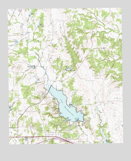
Lake Weatherford, TX USGS Topographic Map
Click on map above to begin viewing in our Map Viewer.

This topographic map contains these locations and features:
Feature Name Type Latitude Longitude GNIS ID View Map
Bethel CemeteryCemeteryN32.8729°W97.7186°1330484View Map
Blue Skies AirportAirportN32.8740°W97.6614°1386196View Map
Brown BranchStreamN32.8429°W97.7286°1331335View Map
Carter CreekStreamN32.8712°W97.7442°1332218View Map
Church of GodChurchN32.7565°W97.7298°2023864View Map
City of Hudson OaksCivilN32.7509°W97.6999°2410801View Map
City of Willow ParkCivilN32.7548°W97.6500°2412271View Map
Clark CemeteryCemeteryN32.8448°W97.7159°1332883View Map
Clear Fork ChurchChurchN32.8079°W97.6911°1332942View Map
Clear Fork Ski HavenLocaleN32.7721°W97.6853°1384338View Map
Clearfork Baptist ChurchChurchN32.8079°W97.6914°2023829View Map
Cornerstone Assembly of God ChurchChurchN32.7757°W97.6681°2023821View Map
Cross Wind AirportAirportN32.8579°W97.7497°1387728View Map
DiceyPopulated PlaceN32.8073°W97.6992°1378213View Map
Dobbs BranchStreamN32.8471°W97.7292°1334421View Map
First Baptist Church of Willow ParkChurchN32.7710°W97.6675°2023837View Map
Friendship ChurchChurchN32.8521°W97.7286°1336239View Map
Green BranchStreamN32.8218°W97.7142°1336905View Map
Hays BranchStreamN32.7998°W97.6984°1337512View Map
Hudson OaksPopulated PlaceN32.7571°W97.7067°1388567View Map
Hudson Oaks City HallBuildingN32.7601°W97.6984°2753717View Map
Hudson Oaks Police DepartmentBuildingN32.7585°W97.7100°2739003View Map
Hudson Oaks Volunteer Fire DepartmentBuildingN32.7584°W97.7099°2551422View Map
Indian CreekStreamN32.7862°W97.7245°1338406View Map
Indian SpringsSpringN32.7962°W97.7117°1338461View Map
Lake WeatherfordReservoirN32.7842°W97.6875°1349574View Map
Lake Weatherford DamDamN32.7718°W97.6753°1856649View Map
Mary Martin Elementary SchoolSchoolN32.7726°W97.7145°2008142View Map
McKnight BranchStreamN32.8671°W97.7409°1341250View Map
Moore LakeReservoirN32.7801°W97.6520°1856652View Map
Moore Lake DamDamN32.7801°W97.6520°1856651View Map
Oak Ridge ChurchChurchN32.7621°W97.7095°1343001View Map
Patton BranchStreamN32.8626°W97.7395°1343688View Map
Punkin CenterPopulated PlaceN32.7565°W97.7300°1344632View Map
Rankin BranchStreamN32.8485°W97.7309°1344798View Map
Reservoir Number EighteenReservoirN32.8595°W97.7165°1345067View Map
Reservoir Number NineteenReservoirN32.8213°W97.7228°1345068View Map
Reservoir Number SeventeenReservoirN32.8443°W97.7404°1345066View Map
Reservoir Number SixteenReservoirN32.8696°W97.7260°1375712View Map
Reservoir Number TwentyoneReservoirN32.8188°W97.6860°1345072View Map
Reservoir Number TwentythreeReservoirN32.7527°W97.6455°1384275View Map
Reservoir Number Twentytwo AReservoirN32.8090°W97.7182°1345073View Map
Shangri-La RanchLocaleN32.8387°W97.6461°1346969View Map
Simmons CemeteryCemeteryN32.7929°W97.7061°1347142View Map
Soil Conservation Service Site 16 DamDamN32.8685°W97.7253°1856635View Map
Soil Conservation Service Site 16 ReservoirReservoirN32.8685°W97.7253°1856636View Map
Soil Conservation Service Site 16a DamDamN32.8735°W97.7353°1856637View Map
Soil Conservation Service Site 16a ReservoirReservoirN32.8735°W97.7353°1856638View Map
Soil Conservation Service Site 17 DamDamN32.8451°W97.7386°1856639View Map
Soil Conservation Service Site 18 DamDamN32.8585°W97.7170°1856641View Map
Soil Conservation Service Site 19 DamDamN32.8218°W97.7220°1856643View Map
Soil Conservation Service Site 21 DamDamN32.8185°W97.6870°1856645View Map
Soil Conservation Service Site 22a DamDamN32.8101°W97.7170°1856647View Map
Turner CemeteryCemeteryN32.7940°W97.6822°1348907View Map
Valley Oaks Airport (historical)AirportN32.8354°W97.7464°1387730View Map
WamplerPopulated PlaceN32.7774°W97.7356°1379231View Map
Wampler CemeteryCemeteryN32.7724°W97.7453°1349468View Map
Weatherford Fire Department Station 2BuildingN32.7694°W97.6837°2551407View Map
Willow ParkPopulated PlaceN32.7626°W97.6506°1388568View Map
Willow Park Church of ChristChurchN32.7710°W97.6736°2023862View Map
Willow Park Fire Rescue Department Station 2BuildingN32.7802°W97.6606°2551793View Map
WrightPopulated PlaceN32.8507°W97.7334°1379295View Map
Wright CemeteryCemeteryN32.8265°W97.7323°1350610View Map

Note: Coordinates in the location and feature list above are referenced to NAD83 datum.


Copyright (C) 2008-2025 Ryan Niemi / Sunset Dynamics ... All Rights Reserved