TopoQuest Logo
Do you find TopoQuest useful?
Help keep TopoQuest running and adding new maps/features by donating!
Bitcoin:  19c7KJd3qBynnjoSw5npx9KScwjBe4ifkT
Litecoin:  LXs6TkuXGGXo1vDsWCkWVdjQX94eUKd6ui
Home View Maps Find Maps Find Places Resources & Links


Springtown, Texas Topographic Map

USGS Map Title: Springtown, TX
USGS Map MRC: 32097H6
DRG (GeoTIFF) Download: o32097h6.tif


Neighboring USGS Topographic Map Quads:


  Boonsville, TX  
33097A7
 

  Cottondale, TX  
33097A6
 

  Boyd, TX  
33097A5
 

  Poolville, TX  
32097H7
 

  Springtown, TX  
32097H6
 

  Azle, TX  
32097H5
 

  Weatherford North, TX  
32097G7
 

  Lake Weatherford, TX  
32097G6
 

  Springtown SE, TX  
32097G5


Map MRC Location:

N33°
W98°
N33°
W97°
H8 H7 H6 H5 H4 H3 H2 H1
G8 G7 G6 G5 G4 G3 G2 G1
F8 F7 F6 F5 F4 F3 F2 F1
E8 E7 E6 E5 E4 E3 E2 E1
D8 D7 D6 D5 D4 D3 D2 D1
C8 C7 C6 C5 C4 C3 C2 C1
B8 B7 B6 B5 B4 B3 B2 B1
A8 A7 A6 A5 A4 A3 A2 A1
N32°
W98°
N32°
W97°

Springtown, TX USGS 1:24K Topographic Map Preview:
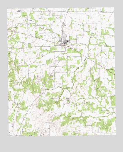
Springtown, TX USGS Topographic Map
Click on map above to begin viewing in our Map Viewer.

This topographic map contains these locations and features:
Feature Name Type Latitude Longitude GNIS ID View Map
Abundant Life Church of GodChurchN32.9615°W97.6828°2023863View Map
Browders CreekStreamN32.9637°W97.6681°1331331View Map
Bud Clark CemeteryCemeteryN32.8962°W97.6356°1331524View Map
CarterPopulated PlaceN32.9068°W97.7414°1378093View Map
City of SpringtownCivilN32.9695°W97.6807°2411962View Map
Dry BranchStreamN32.9685°W97.6428°1373455View Map
First Baptist ChurchChurchN32.9690°W97.6845°2023833View Map
Flying E Ranch AirportAirportN32.9925°W97.6726°2675881View Map
Fundamental Baptist ChurchChurchN32.9685°W97.6845°2023839View Map
GoshenPopulated PlaceN32.9610°W97.7467°1378371View Map
Goshen CemeteryCemeteryN32.9615°W97.7439°1336744View Map
Goshen CreekStreamN32.9762°W97.7000°1336745View Map
Hangmans HollowValleyN32.9233°W97.6916°1337305View Map
Heritage MuseumBuildingN32.9904°W97.7009°2032343View Map
Highland AdditionLocaleN32.9385°W97.6345°1337726View Map
Highland AdditionPopulated PlaceN32.9368°W97.6306°2034568View Map
Highland ChurchChurchN32.9204°W97.6470°1337732View Map
KMQX-FM (Springtown)TowerN32.9815°W97.7053°1388087View Map
Koontz Heliport HeliportAirportN32.9715°W97.6253°1387580View Map
Lick BranchStreamN32.9207°W97.6867°1339897View Map
Mill BranchStreamN32.8968°W97.6286°1341612View Map
New Life Family Fellowship ChurchChurchN32.9635°W97.6853°2023808View Map
Parker County Constable's Office Precinct 1BuildingN32.9532°W97.6632°2739112View Map
Porcupine StadiumParkN32.9798°W97.6920°2027735View Map
SpringtownPopulated PlaceN32.9660°W97.6836°1379105View Map
Springtown City HallBuildingN32.9663°W97.6836°2753220View Map
Springtown Hinkle Elementary SchoolSchoolN32.9682°W97.6817°2008151View Map
Springtown Lipstreu Elementary SchoolSchoolN32.9673°W97.6809°2008152View Map
Springtown Oil FieldOilfieldN32.9815°W97.7131°1347762View Map
Springtown Police DepartmentBuildingN32.9634°W97.6748°2739045View Map
Springtown Post OfficePost OfficeN32.9613°W97.6796°2732303View Map
Springtown Volunteer Fire Department Station 1BuildingN32.9630°W97.6860°2551734View Map
Springtown Volunteer Fire Department Station 2BuildingN32.9758°W97.7327°2551704View Map
Springtown Watson Elementary SchoolSchoolN32.9710°W97.6831°2008154View Map
Springtown-Reno DivisionCivilN32.8924°W97.6636°1939222View Map
Tater HillSummitN32.9312°W97.7148°1348272View Map
Veal StationLocaleN32.9112°W97.6784°1349211View Map
Woody CreekStreamN32.9657°W97.6409°1350582View Map
Yale Academic CenterSchoolN32.9718°W97.6853°2008158View Map

Note: Coordinates in the location and feature list above are referenced to NAD83 datum.


Copyright (C) 2008-2025 Ryan Niemi / Sunset Dynamics ... All Rights Reserved