TopoQuest Logo
Do you find TopoQuest useful?
Help keep TopoQuest running and adding new maps/features by donating!
Bitcoin:  19c7KJd3qBynnjoSw5npx9KScwjBe4ifkT
Litecoin:  LXs6TkuXGGXo1vDsWCkWVdjQX94eUKd6ui
Home View Maps Find Maps Find Places Resources & Links


Springtown SE, Texas Topographic Map

USGS Map Title: Springtown SE, TX
USGS Map MRC: 32097G5
DRG (GeoTIFF) Download: o32097g5.tif


Neighboring USGS Topographic Map Quads:


  Springtown, TX  
32097H6
 

  Azle, TX  
32097H5
 

  Avondale, TX  
32097H4
 

  Lake Weatherford, TX  
32097G6
 

  Springtown SE, TX  
32097G5
 

  Lake Worth, TX  
32097G4
 

  Annetta, TX  
32097F6
 

  Aledo, TX  
32097F5
 

  Benbrook, TX  
32097F4


Map MRC Location:

N33°
W98°
N33°
W97°
H8 H7 H6 H5 H4 H3 H2 H1
G8 G7 G6 G5 G4 G3 G2 G1
F8 F7 F6 F5 F4 F3 F2 F1
E8 E7 E6 E5 E4 E3 E2 E1
D8 D7 D6 D5 D4 D3 D2 D1
C8 C7 C6 C5 C4 C3 C2 C1
B8 B7 B6 B5 B4 B3 B2 B1
A8 A7 A6 A5 A4 A3 A2 A1
N32°
W98°
N32°
W97°

Springtown SE, TX USGS 1:24K Topographic Map Preview:
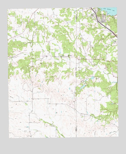
Springtown SE, TX USGS Topographic Map
Click on map above to begin viewing in our Map Viewer.

This topographic map contains these locations and features:
Feature Name Type Latitude Longitude GNIS ID View Map
Aledo Volunteer Fire Department Station 2BuildingN32.7857°W97.5992°2551411View Map
Beggs Ranch-Aledo Airport (historical)AirportN32.7515°W97.6131°1386125View Map
Blue Haze Elementary SchoolSchoolN32.7518°W97.5022°2008694View Map
Bluff Springs ChurchChurchN32.8273°W97.5634°1330950View Map
Bluff Springs SchoolSchoolN32.8285°W97.5564°1330951View Map
Castle Hill EstatePopulated PlaceN32.8673°W97.5159°1332297View Map
Eagle Heights Elementary SchoolSchoolN32.8565°W97.5025°2008654View Map
Elm Grove ChurchChurchN32.8254°W97.5384°1335386View Map
Fire Station Number 33BuildingN32.7595°W97.5012°2427687View Map
First Baptist Church of Castle HillsChurchN32.8635°W97.5200°2023285View Map
Flying Oaks AirportAirportN32.8286°W97.5357°1386671View Map
Fort Worth City ParkParkN32.8124°W97.5022°2028317View Map
Fort Worth Fire Department Station 32BuildingN32.7595°W97.5012°2427686View Map
Haywire Lake Number 1ReservoirN32.8070°W97.5297°1855778View Map
Haywire Lake Number 1 DamDamN32.8085°W97.5286°1855777View Map
Haywire Lake Number 2ReservoirN32.7989°W97.5402°1855776View Map
Haywire Lake Number 2 DamDamN32.8001°W97.5386°1855775View Map
Highway ChapelChurchN32.8685°W97.5261°1337763View Map
Little Silver CreekStreamN32.8354°W97.5853°1340192View Map
Log Cabin AirportAirportN32.8052°W97.6172°1386128View Map
Mary SpringsSpringN32.7918°W97.6086°1998431View Map
Mill CreekStreamN32.8157°W97.5200°1374951View Map
Newsom CemeteryCemeteryN32.8221°W97.5881°1342571View Map
North Texas Emergency Medical ServiceBuildingN32.7997°W97.5806°2655752View Map
Silver Creek ChurchChurchN32.8418°W97.5978°1347129View Map
Silvercreek United Methodist ChurchChurchN32.8576°W97.5936°2023805View Map
Spillway Volunteer Fire DepartmentBuildingN32.8658°W97.5044°2551414View Map
Tanna Hill Intermediate SchoolSchoolN32.7504°W97.5147°2008381View Map
Trinity Baptist ChurchChurchN32.8654°W97.5234°2024074View Map
Walsh LakeReservoirN32.7668°W97.5770°1863876View Map
Walsh Lake DamDamN32.7668°W97.5770°1863875View Map

Note: Coordinates in the location and feature list above are referenced to NAD83 datum.


Copyright (C) 2008-2025 Ryan Niemi / Sunset Dynamics ... All Rights Reserved