TopoQuest Logo
Do you find TopoQuest useful?
Help keep TopoQuest running and adding new maps/features by donating!
Bitcoin:  19c7KJd3qBynnjoSw5npx9KScwjBe4ifkT
Litecoin:  LXs6TkuXGGXo1vDsWCkWVdjQX94eUKd6ui
Home View Maps Find Maps Find Places Resources & Links


Lakeland, Georgia Topographic Map

USGS Map Title: Lakeland, GA
USGS Map MRC: 31083A1
DRG (GeoTIFF) Download: o31083a1.tif


Neighboring USGS Topographic Map Quads:


  Nashville East, GA  
31083B2
 

  Hastings Fish Pond, GA  
31083B1
 

  Henderson Still, GA  
31082B8
 

  Ray City, GA  
31083A2
 

  Lakeland, GA  
31083A1
 

  Sirmans, GA  
31082A8


  Naylor, GA  
30083H1


Map MRC Location:

N32°
W84°
N32°
W83°
H8 H7 H6 H5 H4 H3 H2 H1
G8 G7 G6 G5 G4 G3 G2 G1
F8 F7 F6 F5 F4 F3 F2 F1
E8 E7 E6 E5 E4 E3 E2 E1
D8 D7 D6 D5 D4 D3 D2 D1
C8 C7 C6 C5 C4 C3 C2 C1
B8 B7 B6 B5 B4 B3 B2 B1
A8 A7 A6 A5 A4 A3 A2 A1
N31°
W84°
N31°
W83°

Lakeland, GA USGS 1:24K Topographic Map Preview:
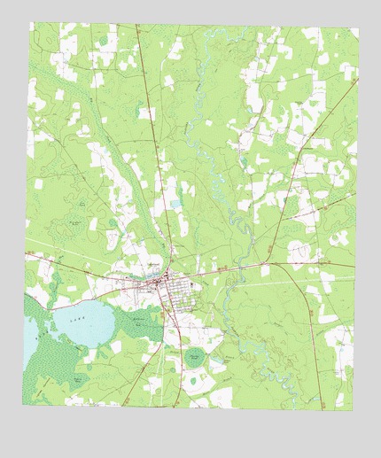
Lakeland, GA USGS Topographic Map
Click on map above to begin viewing in our Map Viewer.

This topographic map contains these locations and features:
Feature Name Type Latitude Longitude GNIS ID View Map
Alligator RunStreamN31.0313°W83.1154°310489View Map
Banks LakeReservoirN31.0267°W83.1028°342179View Map
Banks Lake DamDamN31.0352°W83.0982°342178View Map
Banks Lake National Wildlife RefugeParkN31.0230°W83.1222°2765188View Map
Ben CreekStreamN31.0602°W83.0415°311072View Map
Berryhill PondSwampN31.0499°W83.1093°311119View Map
Big CreekStreamN31.0313°W83.0499°311363View Map
Browning ChapelChurchN31.1005°W83.0207°311885View Map
City of LakelandCivilN31.0410°W83.0748°2404872View Map
CourthouseLocaleN31.0855°W83.0210°313042View Map
Cross CreekStreamN31.1230°W83.0571°313160View Map
Dampier BranchStreamN31.0321°W83.0479°313276View Map
Darsey Mill BranchStreamN31.0188°W83.0410°313317View Map
Darsey PondReservoirN31.0169°W83.0599°313318View Map
East Lanier DivisionCivilN31.0327°W83.0062°1936241View Map
Fender ChurchChurchN31.0844°W83.0443°314103View Map
First Born ChurchChurchN31.0324°W83.0621°314136View Map
Howell LakeReservoirN31.0668°W83.0680°342183View Map
Howell Lake DamDamN31.0669°W83.0665°342182View Map
Lake IrmaReservoirN31.0432°W83.0763°315938View Map
Lake Irma DamDamN31.0435°W83.0740°342180View Map
LakelandPopulated PlaceN31.0410°W83.0751°356347View Map
Lakeland - Lanier Fire and RescueBuildingN31.0346°W83.0723°2603780View Map
Lakeland DivisionCivilN31.0422°W83.1101°1936350View Map
Lakeland Police DepartmentBuildingN31.0401°W83.0752°2733866View Map
Lanier CountyCivilN31.0379°W83.0627°348102View Map
Lanier County High SchoolSchoolN31.0405°W83.0615°348098View Map
Lanier County Middle SchoolSchoolN31.0388°W83.0751°348099View Map
Lanier County Primary SchoolSchoolN31.0430°W83.0718°348100View Map
Lanier County Sheriff's DepartmentBuildingN31.0415°W83.0756°2733495View Map
Lee PondSwampN31.0659°W83.1038°316741View Map
Lightsey HammockIslandN31.0058°W83.1171°316856View Map
Lovejoy CemeteryCemeteryN31.0130°W83.0049°317441View Map
Mill CreekStreamN31.0480°W83.0676°318185View Map
Milltown BaySwampN31.0267°W83.0825°318290View Map
Moore BranchStreamN31.0110°W83.0326°318429View Map
Pattens PondReservoirN31.0157°W83.0507°320272View Map
Pine IslandsIslandN31.0199°W83.1043°320615View Map
Robert L Patten Probation Detention CenterBuildingN31.0400°W83.0619°2735771View Map
South Georgia Medical Center Lanier CampusHospitalN31.0421°W83.0862°323138View Map
Union ChurchChurchN31.0246°W83.0485°324505View Map

Note: Coordinates in the location and feature list above are referenced to NAD83 datum.


Copyright (C) 2008-2025 Ryan Niemi / Sunset Dynamics ... All Rights Reserved