TopoQuest Logo
Do you find TopoQuest useful?
Help keep TopoQuest running and adding new maps/features by donating!
Bitcoin:  19c7KJd3qBynnjoSw5npx9KScwjBe4ifkT
Litecoin:  LXs6TkuXGGXo1vDsWCkWVdjQX94eUKd6ui
Home View Maps Find Maps Find Places Resources & Links


Ray City, Georgia Topographic Map

USGS Map Title: Ray City, GA
USGS Map MRC: 31083A2
DRG (GeoTIFF) Download: o31083a2.tif


Neighboring USGS Topographic Map Quads:


  Nashville West, GA  
31083B3
 

  Nashville East, GA  
31083B2
 

  Hastings Fish Pond, GA  
31083B1
 

  New Lois, GA  
31083A3
 

  Ray City, GA  
31083A2
 

  Lakeland, GA  
31083A1
 

  Hahira East, GA  
30083H3


  Naylor, GA  
30083H1


Map MRC Location:

N32°
W84°
N32°
W83°
H8 H7 H6 H5 H4 H3 H2 H1
G8 G7 G6 G5 G4 G3 G2 G1
F8 F7 F6 F5 F4 F3 F2 F1
E8 E7 E6 E5 E4 E3 E2 E1
D8 D7 D6 D5 D4 D3 D2 D1
C8 C7 C6 C5 C4 C3 C2 C1
B8 B7 B6 B5 B4 B3 B2 B1
A8 A7 A6 A5 A4 A3 A2 A1
N31°
W84°
N31°
W83°

Ray City, GA USGS 1:24K Topographic Map Preview:
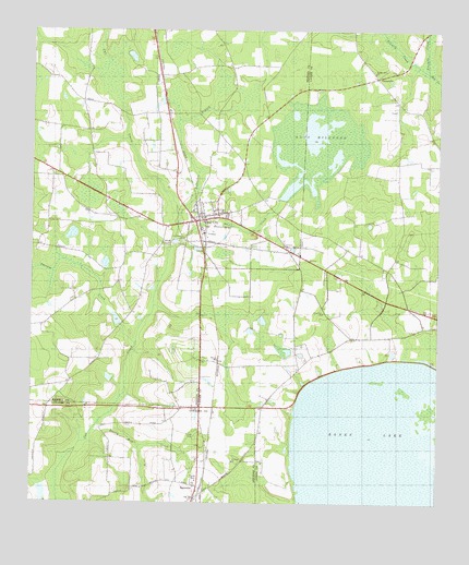
Ray City, GA USGS Topographic Map
Click on map above to begin viewing in our Map Viewer.

This topographic map contains these locations and features:
Feature Name Type Latitude Longitude GNIS ID View Map
Banks LakeLakeN31.0144°W83.1374°354449View Map
BarrettsPopulated PlaceN31.0016°W83.1993°310827View Map
Batterbee BranchStreamN31.0760°W83.2046°310860View Map
Beatty Mill CreekStreamN31.0185°W83.2315°310967View Map
Beaverdam CreekStreamN31.0699°W83.2060°310994View Map
City of Ray CityCivilN31.0757°W83.1969°2404595View Map
First Baptist Church of Ray CityChurchN31.0716°W83.1971°346067View Map
Fivemile CreekStreamN31.1138°W83.1285°355815View Map
Holiness ChurchChurchN31.0680°W83.1727°315535View Map
Knight Memorial ChurchChurchN31.1141°W83.1446°316495View Map
New Ramey ChurchChurchN31.0699°W83.2032°319518View Map
Peters BaySwampN31.0050°W83.1467°320406View Map
Peters LakeReservoirN31.0029°W83.2466°342199View Map
Peters Lake DamDamN31.0019°W83.2449°342198View Map
Possum CreekStreamN31.0419°W83.2174°321079View Map
Ray CityPopulated PlaceN31.0746°W83.1993°332800View Map
Ray City CemeteryCemeteryN31.0727°W83.1971°346104View Map
Ray City DivisionCivilN31.0821°W83.2367°1936482View Map
Ray City Police DepartmentBuildingN31.0752°W83.1974°2733574View Map
Ray City Volunteer Fire DepartmentBuildingN31.0748°W83.1980°2604263View Map
Rays Mill (historical)LocaleN31.0805°W83.1743°346105View Map
Rays Mill Pond DamDamN31.0974°W83.1638°342144View Map
Rays MillpondReservoirN31.0938°W83.1639°321342View Map
Saint Johns ChurchChurchN31.0113°W83.1877°322107View Map
Silver Hill ChurchChurchN31.0505°W83.1602°322987View Map
TeetervillePopulated PlaceN31.1127°W83.1438°333200View Map
Tenmile CreekStreamN31.1141°W83.1282°323992View Map
Westside Fire StationBuildingN31.0365°W83.1916°2604104View Map
WHFE-FM (Lakeland)TowerN31.0821°W83.1796°352720View Map
WHFE-FM (Lakeland)TowerN31.0574°W83.2304°352721View Map

Note: Coordinates in the location and feature list above are referenced to NAD83 datum.


Copyright (C) 2008-2025 Ryan Niemi / Sunset Dynamics ... All Rights Reserved