TopoQuest Logo
Do you find TopoQuest useful?
Help keep TopoQuest running and adding new maps/features by donating!
Bitcoin:  19c7KJd3qBynnjoSw5npx9KScwjBe4ifkT
Litecoin:  LXs6TkuXGGXo1vDsWCkWVdjQX94eUKd6ui
Home View Maps Find Maps Find Places Resources & Links


Lakeside, Arizona Topographic Map

USGS Map Title: Lakeside, AZ
USGS Map MRC: 34109B8
DRG (GeoTIFF) Download: o34109b8.tif


Neighboring USGS Topographic Map Quads:


  Show Low North, AZ  
34110C1
 

  Silver Springs, AZ  
34109C8
 

  Ortega Mountain, AZ  
34109C7
 

  Show Low South, AZ  
34110B1
 

  Lakeside, AZ  
34109B8
 

  Sponseller Mountain, AZ  
34109B7
 

  Faught Ridge, AZ  
34110A1
 

  Indian Pine, AZ  
34109A8
 

  McNary, AZ  
34109A7


Map MRC Location:

N35°
W110°
N35°
W109°
H8 H7 H6 H5 H4 H3 H2 H1
G8 G7 G6 G5 G4 G3 G2 G1
F8 F7 F6 F5 F4 F3 F2 F1
E8 E7 E6 E5 E4 E3 E2 E1
D8 D7 D6 D5 D4 D3 D2 D1
C8 C7 C6 C5 C4 C3 C2 C1
B8 B7 B6 B5 B4 B3 B2 B1
A8 A7 A6 A5 A4 A3 A2 A1
N34°
W110°
N34°
W109°

Lakeside, AZ USGS 1:24K Topographic Map Preview:
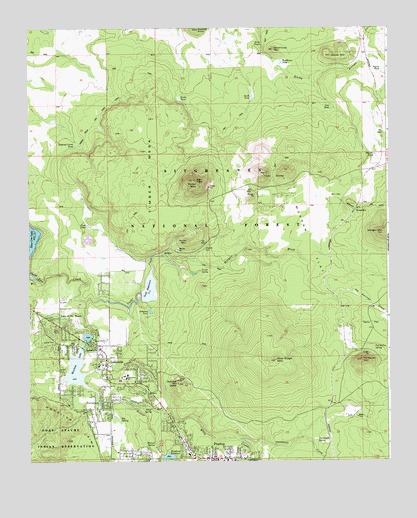
Lakeside, AZ USGS Topographic Map
Click on map above to begin viewing in our Map Viewer.

This topographic map contains these locations and features:
Feature Name Type Latitude Longitude GNIS ID View Map
Adair SpringSpringN34.1402°W109.9576°25522View Map
Big SpringSpringN34.1372°W109.9686°26295View Map
Billy CreekStreamN34.1717°W109.9807°26342View Map
Blue Ridge Catchment DamDamN34.1520°W109.9204°40156View Map
Blue Ridge Elementary / Middle SchoolSchoolN34.1681°W109.9741°2543725View Map
Blue Ridge High SchoolSchoolN34.1494°W109.9668°26526View Map
Blue Ridge Junior High SchoolSchoolN34.1495°W109.9682°2543595View Map
Blue Ridge Middle SchoolSchoolN34.1485°W109.9686°2543655View Map
Blue Ridge MountainSummitN34.1542°W109.9148°26527View Map
Blueridge TankReservoirN34.1745°W109.9112°40159View Map
Calvary Chapel of the White MountainsChurchN34.1582°W109.9862°2670680View Map
Chet TankReservoirN34.2222°W109.9888°42065View Map
Cholla TankReservoirN34.2384°W109.9456°40165View Map
Dipping Corral TankReservoirN34.2163°W109.9840°28482View Map
Elk Springs DrawValleyN34.1717°W109.8932°28860View Map
Fird TankReservoirN34.2151°W109.9950°42066View Map
First Baptist Church of PinetopChurchN34.1253°W109.9328°2670952View Map
Flume MountainSummitN34.1884°W109.9448°29076View Map
Frost TankReservoirN34.1932°W109.9795°29218View Map
Galahad TankReservoirN34.2408°W109.9151°1853724View Map
Gawain TankReservoirN34.1742°W109.8883°41984View Map
Grail TankReservoirN34.1707°W109.8916°1853721View Map
Gunnybag TankReservoirN34.1934°W109.9766°1853718View Map
Homestead Mobile Home ParkPopulated PlaceN34.1425°W109.9802°2670278View Map
Jaques MarshSwampN34.1866°W109.9831°1853728View Map
Jaques MountainSummitN34.2420°W109.8948°30506View Map
Jaques SpringSpringN34.1863°W109.9391°30507View Map
Jaques TankReservoirN34.2381°W109.8765°30508View Map
KKGL-FM (Pinetop)TowerN34.2056°W109.9412°45227View Map
KRFM-FM (Show Low)TowerN34.2056°W109.9412°43492View Map
Lake of the WoodsReservoirN34.1611°W109.9797°40297View Map
Lake of the WoodsPopulated PlaceN34.1639°W109.9896°30843View Map
Lake of the Woods Census Designated PlaceCensusN34.1548°W109.9936°2582812View Map
Lake of the Woods DamDamN34.1617°W109.9773°40203View Map
LakesidePopulated PlaceN34.1545°W109.9734°30856View Map
Lakeside CampgroundLocaleN34.1575°W109.9793°40204View Map
Lakeside CemeteryCemeteryN34.1524°W109.9890°2669729View Map
Lakeside DamDamN34.1584°W109.9823°40205View Map
Lakeside Post OfficePost OfficeN34.1529°W109.9747°2669641View Map
Lakeside Ranger StationLocaleN34.1584°W109.9768°40206View Map
Larson Memorial Public LibraryBuildingN34.1487°W109.9718°2669421View Map
Log Cabin SpringSpringN34.1637°W109.9523°40208View Map
Morgan Draw TankReservoirN34.1832°W109.9422°40221View Map
Morgan FlatFlatN34.1878°W109.9023°32025View Map
Morgan WashStreamN34.1859°W109.9518°32033View Map
Morgan Wash TankReservoirN34.1832°W109.9422°41985View Map
New TankReservoirN34.2270°W109.8948°32298View Map
Pat Mullen MountainSummitN34.1539°W109.8845°32720View Map
Pat Mullen SpringSpringN34.1577°W109.8804°32721View Map
Peterson SpringSpringN34.1666°W109.9528°1853726View Map
Peterson SpringSpringN34.1654°W109.9540°40232View Map
Peterson TankReservoirN34.1682°W109.9579°32831View Map
PinetopPopulated PlaceN34.1259°W109.9376°32990View Map
Pinetop - Lakeside Police DepartmentBuildingN34.1527°W109.9760°2672297View Map
Pinetop - Lakeside Sanitary District Wastewater Treatment FacilityLocaleN34.1705°W109.9835°2669620View Map
Pinetop - Lakeside Town HallBuildingN34.1527°W109.9760°2669590View Map
Pinetop Post OfficePost OfficeN34.1309°W109.9461°44969View Map
Pinetop-LakesidePopulated PlaceN34.1425°W109.9604°1669454View Map
Pinetop-Lakeside Sanitary PlantLocaleN34.1709°W109.9823°1853729View Map
Ponderosa Plaza Shopping CenterLocaleN34.1267°W109.9437°40237View Map
Porter CreekStreamN34.1712°W109.9804°33112View Map
Porter MountainSummitN34.2059°W109.9429°33114View Map
Porter Mountain Fellowship Southern Baptist ChurchChurchN34.1658°W109.9730°2671717View Map
Porter SpringSpringN34.1800°W109.9404°33117View Map
Porter SpringSpringN34.1786°W109.9432°41986View Map
Porter TankReservoirN34.2297°W109.9476°33119View Map
Rainbow LakeReservoirN34.1515°W109.9836°33340View Map
Rainbow Lake Boat RampLocaleN34.1573°W109.9831°2669949View Map
Rainbow Lake CampgroundLocaleN34.1423°W109.9804°40239View Map
Rainbow Lake Mobile Home ParkPopulated PlaceN34.1603°W109.9932°2670405View Map
RB TankReservoirN34.1366°W109.8963°41987View Map
Renaissance Academy Anasazi CampusSchoolN34.1310°W109.9475°2543639View Map
Rock TanksReservoirN34.2448°W109.9187°33750View Map
Running Bear Mobile ResortPopulated PlaceN34.1628°W109.9910°2669765View Map
Sawmill TankReservoirN34.2011°W109.9814°42067View Map
Scott DamDamN34.1717°W109.9607°40246View Map
Scott Reservior CampgroundLocaleN34.1755°W109.9608°2670346View Map
Scott ReservoirReservoirN34.1750°W109.9583°34163View Map
Scott Reservoir Boat LaunchLocaleN34.1744°W109.9610°2670183View Map
Section 15 TankReservoirN34.1831°W109.8948°1853720View Map
Section Eleven TankReservoirN34.1892°W109.9815°40247View Map
Section Ten TankReservoirN34.1978°W109.9962°40249View Map
Section Thirty-four TankReservoirN34.2236°W109.9906°40252View Map
Shadowfax TankReservoirN34.1365°W109.8964°41988View Map
Shadowfax TankReservoirN34.1302°W109.9256°41989View Map
Ski Hi Retreat TankReservoirN34.1616°W109.8889°40270View Map
South TankReservoirN34.2299°W109.9219°34685View Map
SponsellerPopulated PlaceN34.1964°W109.8873°34717View Map
Sponseller TankReservoirN34.1999°W109.8917°42068View Map
Spoonseller SidingSpringN34.1998°W109.8912°42069View Map
Springer MountainSummitN34.1475°W109.9484°34746View Map
Stewart TankReservoirN34.2133°W109.8798°34851View Map
Tenny FlatFlatN34.1648°W109.8812°35195View Map
The Church of Jesus Christ of Latter Day SaintsChurchN34.1541°W109.9756°2671366View Map
Thompson CreekStreamN34.1314°W109.9270°35280View Map
Thompson SpringSpringN34.1309°W109.9000°35289View Map
Timber MesaSummitN34.2089°W109.9582°35327View Map
Timber Mesa Fire and Medical Station 13BuildingN34.1629°W109.9859°2672373View Map
Town of Pinetop-LakesideCivilN34.1486°W109.9658°2413136View Map
Twin KnollsSummitN34.2089°W109.9098°35619View Map
Walnut CreekStreamN34.1639°W109.9807°35854View Map
Walnut SpringSpringN34.1301°W109.9566°35874View Map
Whipple TankReservoirN34.1778°W109.8762°42070View Map
Woodland CampgroundLocaleN34.1267°W109.9493°40294View Map
Woodland DamDamN34.1267°W109.9540°40295View Map
Woodland Lake Park Boat LaunchLocaleN34.1277°W109.9526°2669950View Map
Woodland ReservoirReservoirN34.1264°W109.9519°36377View Map
Woolhouse MountainSummitN34.2437°W109.9146°36396View Map
Woolhouse TankReservoirN34.2399°W109.9120°36397View Map

Note: Coordinates in the location and feature list above are referenced to NAD83 datum.


Copyright (C) 2008-2024 Ryan Niemi / Sunset Dynamics ... All Rights Reserved