TopoQuest Logo
Do you find TopoQuest useful?
Help keep TopoQuest running and adding new maps/features by donating!
Bitcoin:  19c7KJd3qBynnjoSw5npx9KScwjBe4ifkT
Litecoin:  LXs6TkuXGGXo1vDsWCkWVdjQX94eUKd6ui
Home View Maps Find Maps Find Places Resources & Links


McNary, Arizona Topographic Map

USGS Map Title: McNary, AZ
USGS Map MRC: 34109A7
DRG (GeoTIFF) Download: o34109a7.tif


Neighboring USGS Topographic Map Quads:


  Lakeside, AZ  
34109B8
 

  Sponseller Mountain, AZ  
34109B7
 

  Boundary Butte, AZ  
34109B6
 

  Indian Pine, AZ  
34109A8
 

  McNary, AZ  
34109A7
 

  Horseshoe Cienega, AZ  
34109A6
 

  Alchesay Flat, AZ  
33109H8
 

  Hawley Lake West, AZ  
33109H7
 

  Hawley Lake East, AZ  
33109H6


Map MRC Location:

N35°
W110°
N35°
W109°
H8 H7 H6 H5 H4 H3 H2 H1
G8 G7 G6 G5 G4 G3 G2 G1
F8 F7 F6 F5 F4 F3 F2 F1
E8 E7 E6 E5 E4 E3 E2 E1
D8 D7 D6 D5 D4 D3 D2 D1
C8 C7 C6 C5 C4 C3 C2 C1
B8 B7 B6 B5 B4 B3 B2 B1
A8 A7 A6 A5 A4 A3 A2 A1
N34°
W110°
N34°
W109°

McNary, AZ USGS 1:24K Topographic Map Preview:
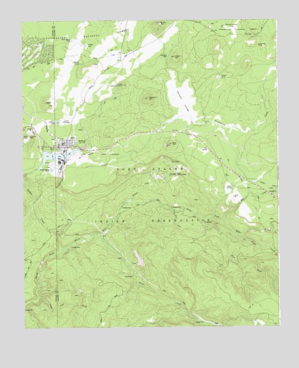
McNary, AZ USGS Topographic Map
Click on map above to begin viewing in our Map Viewer.

This topographic map contains these locations and features:
Feature Name Type Latitude Longitude GNIS ID View Map
Blue LakeLakeN34.0671°W109.8029°26509View Map
Blue Lake Recreation SiteLocaleN34.0667°W109.8023°45033View Map
Blue MountainSummitN34.0748°W109.8023°26512View Map
Bog CreekStreamN34.0437°W109.7782°26573View Map
Boundary TankReservoirN34.1146°W109.7596°26662View Map
Boy Creek CampgroundLocaleN34.0539°W109.7534°39011View Map
Boy SpringSpringN34.0723°W109.7845°26691View Map
Boyce SpringSpringN34.0570°W109.7726°26693View Map
Brushy MountainSummitN34.1239°W109.8079°26837View Map
Buck Spring TankReservoirN34.1171°W109.8509°26877View Map
Club TankReservoirN34.1179°W109.8741°45034View Map
Cluff CienegaFlatN34.0842°W109.8518°27747View Map
Cyclone DamDamN34.0134°W109.7707°39031View Map
Gobbler SeepSpringN34.1147°W109.8429°29369View Map
Gomez CreekStreamN34.0309°W109.8551°29407View Map
Gooseberry CreekStreamN34.0373°W109.8579°29420View Map
Gooseberry Dam LakeLakeN34.0681°W109.8320°29421View Map
Haystack CienegaFlatN34.0920°W109.7968°29812View Map
Haystack MountainSummitN34.0934°W109.8137°29815View Map
Haystack TankReservoirN34.1106°W109.8035°29817View Map
Kinney MountainSummitN34.0778°W109.8723°30781View Map
Largo MountainSummitN34.0906°W109.8620°30882View Map
Little Haystack MountainSummitN34.0987°W109.8262°31078View Map
Logger MountainSummitN34.1100°W109.8007°31193View Map
Lone Pine CreekStreamN34.0125°W109.8679°31207View Map
McNaryPopulated PlaceN34.0737°W109.8570°31683View Map
McNary Annex SchoolSchoolN34.0764°W109.8548°39080View Map
McNary Apache Baptist ChurchChurchN34.0730°W109.8610°2671218View Map
McNary Census Designated PlaceCensusN34.0923°W109.8541°2408802View Map
McNary Elementary SchoolSchoolN34.0750°W109.8565°39081View Map
McNary High SchoolSchoolN34.0745°W109.8557°39082View Map
McNary Post OfficePost OfficeN34.0728°W109.8533°2670491View Map
McNary Railroad StationBuildingN34.0720°W109.8404°39083View Map
McNary TankReservoirN34.0838°W109.8581°31686View Map
No Name CreekStreamN34.0384°W109.7715°32331View Map
Painted Desert InterchangeCrossingN34.0606°W109.7807°21737View Map
Penrod TankReservoirN34.1021°W109.7778°32788View Map
Pinetop Country ClubLocaleN34.1125°W109.8687°43204View Map
Reservation FlatFlatN34.1214°W109.7723°33580View Map
Sand CreekStreamN34.0445°W109.7865°34032View Map
Slide CreekStreamN34.0473°W109.8007°34534View Map
Trout CreekStreamN34.0381°W109.8373°35479View Map
Twomile SpringSpringN34.1075°W109.8465°35649View Map
Twomile Spring TankReservoirN34.1076°W109.8467°39181View Map
Williams CreekStreamN34.0506°W109.8248°36210View Map
Williams Creek National Fish HatcheryParkN34.0606°W109.8057°36211View Map

Note: Coordinates in the location and feature list above are referenced to NAD83 datum.


Copyright (C) 2008-2025 Ryan Niemi / Sunset Dynamics ... All Rights Reserved