TopoQuest Logo
Do you find TopoQuest useful?
Help keep TopoQuest running and adding new maps/features by donating!
Bitcoin:  19c7KJd3qBynnjoSw5npx9KScwjBe4ifkT
Litecoin:  LXs6TkuXGGXo1vDsWCkWVdjQX94eUKd6ui
Home View Maps Find Maps Find Places Resources & Links


Lakeville, Indiana Topographic Map

USGS Map Title: Lakeville, IN
USGS Map MRC: 41086E3
DRG (GeoTIFF) Download: o41086e3.tif


Neighboring USGS Topographic Map Quads:


  Lydick, IN  
41086F4
 

  South Bend West, IN  
41086F3
 

  South Bend East, IN  
41086F2
 

  North Liberty, IN  
41086E4
 

  Lakeville, IN  
41086E3
 

  Wyatt, IN  
41086E2
 

  Walkerton, IN  
41086D4
 

  La Paz, IN  
41086D3
 

  Bremen, IN  
41086D2


Map MRC Location:

N42°
W87°
N42°
W86°
H8 H7 H6 H5 H4 H3 H2 H1
G8 G7 G6 G5 G4 G3 G2 G1
F8 F7 F6 F5 F4 F3 F2 F1
E8 E7 E6 E5 E4 E3 E2 E1
D8 D7 D6 D5 D4 D3 D2 D1
C8 C7 C6 C5 C4 C3 C2 C1
B8 B7 B6 B5 B4 B3 B2 B1
A8 A7 A6 A5 A4 A3 A2 A1
N41°
W87°
N41°
W86°

Lakeville, IN USGS 1:24K Topographic Map Preview:
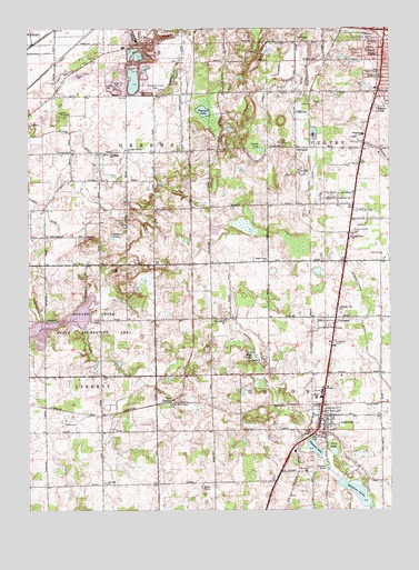
Lakeville, IN USGS Topographic Map
Click on map above to begin viewing in our Map Viewer.

This topographic map contains these locations and features:
Feature Name Type Latitude Longitude GNIS ID View Map
Authen DitchCanalN41.6014°W86.2800°452534View Map
Camp MillhouseParkN41.6028°W86.3642°452557View Map
Camp WakindaParkN41.5953°W86.2850°452558View Map
Catfish LakeLakeN41.5935°W86.2947°452560View Map
Centre Township Fire DepartmentBuildingN41.6086°W86.2529°2625708View Map
ColburnPopulated PlaceN41.5489°W86.2683°452571View Map
Dipper LakeLakeN41.5112°W86.2723°452580View Map
Dixon West Place DitchCanalN41.6220°W86.3708°452581View Map
Eberly DitchCanalN41.6109°W86.2922°452584View Map
Fites LakeLakeN41.5153°W86.2697°452600View Map
Gilmer ParkPopulated PlaceN41.6198°W86.2517°452607View Map
Greene Elementary SchoolSchoolN41.5925°W86.3439°452611View Map
Heston DitchCanalN41.5362°W86.2947°452624View Map
LakevillePopulated PlaceN41.5245°W86.2733°452658View Map
Lakeville CemeteryCemeteryN41.5432°W86.2697°452659View Map
Lakeville Elementary SchoolSchoolN41.5292°W86.2736°452865View Map
Lakeville Police DepartmentBuildingN41.5242°W86.2750°2758464View Map
Lakeville Union Township Fire DepartmentBuildingN41.5237°W86.2738°2625901View Map
Maple Grove ChurchChurchN41.5648°W86.2917°452679View Map
Moon LakeLakeN41.5404°W86.2977°452693View Map
Mount Calvary CemeteryCemeteryN41.5721°W86.2632°452697View Map
NutwoodPopulated PlaceN41.5939°W86.2820°452711View Map
Olive Branch ChurchChurchN41.5495°W86.3064°452717View Map
Pine StationPopulated PlaceN41.5281°W86.3256°452732View Map
Pleasant LakeLakeN41.5163°W86.2764°452737View Map
Pleasant View ChurchChurchN41.5523°W86.2667°452740View Map
Porter CemeteryCemeteryN41.5492°W86.3528°452742View Map
Potato Creek Reservoir DamDamN41.5500°W86.3717°452872View Map
Potato Creek State ParkParkN41.5525°W86.3481°452744View Map
Reeves HillSummitN41.5698°W86.3533°452748View Map
Riddles LakeLakeN41.5051°W86.2620°452750View Map
Sacred Heart ChurchChurchN41.5706°W86.2631°452759View Map
Saint Johns ChurchChurchN41.5070°W86.3483°452768View Map
Saint Joseph CountyCivilN41.6167°W86.2899°452855View Map
Schang DitchCanalN41.5984°W86.3564°452792View Map
Shidler - Hoffman DitchCanalN41.5414°W86.2572°452794View Map
Sommers LakeLakeN41.5708°W86.3460°452795View Map
South Bend SandpitMineN41.6121°W86.3511°2743174View Map
Southlawn CemeteryCemeteryN41.6038°W86.2526°452802View Map
Southlawn CemeteryCemeteryN41.6042°W86.2542°452803View Map
Southside ChurchChurchN41.5975°W86.2589°452804View Map
Sumption Prairie CemeteryCemeteryN41.6087°W86.3306°452810View Map
Sumption Prairie ChurchChurchN41.5934°W86.3411°452811View Map
Suthlawn ChurchChurchN41.6125°W86.2520°452812View Map
Tabor ChurchChurchN41.5348°W86.3495°452814View Map
Town of LakevilleCivilN41.5286°W86.2744°2396705View Map
Township of CentreCivilN41.5998°W86.2539°452853View Map
Township of GreeneCivilN41.5922°W86.3687°452852View Map
Township of UnionCivilN41.5202°W86.2604°453933View Map
Union North Ambulance ServiceBuildingN41.5199°W86.2755°2719361View Map
Valley Bible ChurchChurchN41.6225°W86.2820°452825View Map
Vargo HillSummitN41.5620°W86.3439°452827View Map
Wharton LakeLakeN41.6035°W86.3142°452836View Map
Worster LakeReservoirN41.5493°W86.3632°452856View Map

Note: Coordinates in the location and feature list above are referenced to NAD83 datum.


Copyright (C) 2008-2024 Ryan Niemi / Sunset Dynamics ... All Rights Reserved