TopoQuest Logo
Do you find TopoQuest useful?
Help keep TopoQuest running and adding new maps/features by donating!
Bitcoin:  19c7KJd3qBynnjoSw5npx9KScwjBe4ifkT
Litecoin:  LXs6TkuXGGXo1vDsWCkWVdjQX94eUKd6ui
Home View Maps Find Maps Find Places Resources & Links


Lane Reservoir, California Topographic Map

USGS Map Title: Lane Reservoir, CA
USGS Map MRC: 41120A7
DRG (GeoTIFF) Download: o41120a7.tif


Neighboring USGS Topographic Map Quads:


  Adin, CA  
41120B8
 

  Ambrose Valley, CA  
41120B7
 

  Knox Mountain, CA  
41120B6
 

  Letterbox Hill, CA  
41120A8
 

  Lane Reservoir, CA  
41120A7
 

  Ash Valley, CA  
41120A6
 

  Silva Flat Reservoir, CA  
40120H8
 

  Said Valley, CA  
40120H7
 

  Whitinger Mountain, CA  
40120H6


Map MRC Location:

N42°
W121°
N42°
W120°
H8 H7 H6 H5 H4 H3 H2 H1
G8 G7 G6 G5 G4 G3 G2 G1
F8 F7 F6 F5 F4 F3 F2 F1
E8 E7 E6 E5 E4 E3 E2 E1
D8 D7 D6 D5 D4 D3 D2 D1
C8 C7 C6 C5 C4 C3 C2 C1
B8 B7 B6 B5 B4 B3 B2 B1
A8 A7 A6 A5 A4 A3 A2 A1
N41°
W121°
N41°
W120°

Lane Reservoir, CA USGS 1:24K Topographic Map Preview:
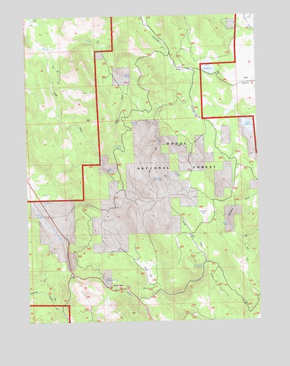
Lane Reservoir, CA USGS Topographic Map
Click on map above to begin viewing in our Map Viewer.

This topographic map contains these locations and features:
Feature Name Type Latitude Longitude GNIS ID View Map
Avila PlacePopulated PlaceN41.0429°W120.8677°1657969View Map
Bert Bath SpringSpringN41.0710°W120.8239°219089View Map
Cottonwood CreekStreamN41.1238°W120.7552°221648View Map
Coyote FlatFlatN41.0421°W120.7808°221747View Map
Coyote Flat DrawValleyN41.0252°W120.7802°221748View Map
Elkins and Lane 1241 DamDamN41.0832°W120.7594°1664272View Map
Foster DrawValleyN41.0829°W120.8583°223726View Map
Foster SpringSpringN41.0624°W120.8327°223731View Map
Hunsinger FlatFlatN41.0816°W120.7805°225779View Map
Johnson Mill SpringSpringN41.0575°W120.8023°1665876View Map
Lane ReservoirReservoirN41.0798°W120.7558°226852View Map
Lower McBride SpringsSpringN41.0171°W120.8358°227780View Map
Moll ReservoirReservoirN41.1036°W120.7767°228908View Map
Niles CabinLocaleN41.1149°W120.8369°229552View Map
Oxendine DrawValleyN41.0513°W120.7516°230182View Map
Scotty PlacePopulated PlaceN41.1241°W120.8739°1659617View Map
Shingle Mill SpringSpringN41.0811°W120.8148°233018View Map
Smith FlatFlatN41.0213°W120.8114°233333View Map
Walker DrawValleyN41.0960°W120.8230°237173View Map
Walker SpringSpringN41.0998°W120.8221°1652867View Map
Wayman SpringSpringN41.0390°W120.7676°237370View Map
Williams ReservoirReservoirN41.0215°W120.7820°237855View Map
Willow Creek CampgroundLocaleN41.0149°W120.8286°277243View Map
Willow Creek StationLocaleN41.0135°W120.8275°237908View Map

Note: Coordinates in the location and feature list above are referenced to NAD83 datum.


Copyright (C) 2008-2024 Ryan Niemi / Sunset Dynamics ... All Rights Reserved